
THE MEGADROUGHT SERIES, PART 1
“Look, Up in the Sky, It’s a… Cloud!”
It sure isn’t Superman
This topic isn’t humorous, but we get excited when two clouds come together here out West. It gives us hope.
But hope is not a plan, and we’re stuck in the same place we’ve been for the last 22 years. Mainly like not planning for a drought that lasts 22 years.
Folks, we’re in trouble.
Big trouble.
The scientists have made it clear that, in the Southwest, the period from 2000 to the present is the driest in 1,200 years, primarily based on tree ring studies. They have also told us vehicle emissions, and exhaust from manmade activities have set the stage for climate change. We did this.
We’re now bearing the consequences of what we as a people previously thought was harmless. It was in the name of progress. But we’ve made Mother Nature do things we couldn’t have even perceived. The shot has already been fired. We now have to deal with the aftermath.
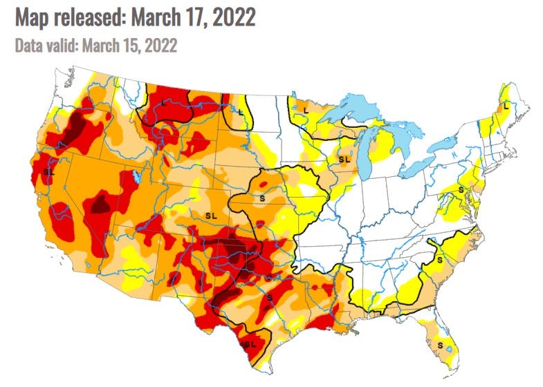
Last fall, the U.S. Drought Monitor published a map of what to expect in drought coverage into 2022. That projection has come to fruition in the map above.
The drought is moving east. Large swaths of eastern Colorado, Texas, Oklahoma, Kansas, and Nebraska are now in severe to exceptional drought. In the eastern Dakotas, the drought has lessened in intensity but remains in the western section of those states.
Because it produces wheat, this is not only known as the nation’s breadbasket but is also a commodity we export to help feed the world. Therefore, as with everything else, expect the price of a loaf of bread and other wheat-based products to be on the rise.
The wind has been a significant factor in producing dustbowl-like conditions on the prairie, on top of it already being one of the windiest areas of the country. Severe winds reaching 100 mph hit Kansas in the middle of December, sparking wildfires. Since then, repeated wind events have tested the winter wheat crop, and farmers are forecasting dismal returns.
Meanwhile, December saw a record amount of rain and snow throughout the state in California. Los Angeles received 9.46”, more than half of what they usually see in a year! Then somebody turned off the spigot during what should have been the wettest part of the year. Since January 1, they’ve had just .33” of rain. Finally, warm temperatures throughout the state led to early snowmelt. Some of it remains, but the reservoirs will be in worse shape than last year without a substantial amount more. And time is running out.
Simply put, the more rain you get, the more rain you get. Thunderstorms form by the meeting of two air masses or daytime radiational heating. In the latter case, the more moisture there is in the soil, the more it will rain.
See the white area in the above map? Those areas have had their fair share of rain. They don’t need anymore. Yet they keep getting more because the ground is already saturated, plenty for a storm to feed off. So flooding is a major concern in those areas.
Hurricanes are hitting the east with increasing frequency and duration. Hurricane Ida was the most expensive extreme weather event in 2021, affecting four of the most flood-prone states: Louisiana, Mississippi, New Jersey, and Pennsylvania. And the rain just keeps on coming.
There’s no moisture in the soil in the West! It is ultra-dry. Dry to the bone. There is no moisture to go into the atmosphere. And when there’s no moisture in the soil, spring run-offs dry before reaching the streams and rivers. Albuquerque has had .40” of precipitation since the first of the year. I’ve never had to water my lawn and outdoor plants in the winter before!
(Okay, I know, the lawn. But it’s small, and it wasn’t my idea.)
Without any evaporation, “dry” thunderstorms are produced. Any moisture in the clouds evaporates as it falls to the ground, leaving you with thunder and lightning. That’s what starts most wildfires. These thunderstorms usually happen at higher elevations where it’s forested and in the deserts.
There is no happy medium.
It is unknown what is causing the current wildfires in central Texas, but a single spark combined with the low humidity and high winds can quickly render a conflagration.
Dismal, isn’t it? To think this is what it takes to get people to think ahead and plan?
It took 22 years to get to where we are today. It will take more than that many years of just average precipitation to see things merely improve. We’ll never really get our heads above water (pun intended).
Part of the reason is that millions more people now live in the same area as before the drought. As a result, the Colorado River, which serves as the basis of the water needs of nearly 50 million people, is stressed and strained. It has given us all it has, and it is hurting.
Last year, I wrote seven stories about the megadrought and its effects on the West. After all, this is where I live. With this series, I’ll be looking at specific places and areas in the drought zone, how they’re living with it, and what plans and innovations they may have to mitigate the damage. But don’t discount climate migration.
And for heaven’s sake, xeriscape!
Please refer to the following articles for more background on the megadrought:
- The History of the Megadrought
- Why are These Cities Here?
- Is a Pipeline the Answer?
- The Colorado River — The West’s Lifeline
- Overview of Climate Change — includes Drought Map
- Roadtripping Through the Heart of the Southwest
- What’s La Niña Got To Do With It?
If you like what you’ve read, why not become a Medium member? It’s just $5/month and gives you access to all of my stories and those of all the other fine writers on Medium. Plus, I get a small commission which helps! Just click on the link below. Thanks for being a reader!