
How The West Went Dry
The history behind the West’s megadrought, simplified
There is no lack of water here unless you try to establish a city where no city should be. ~Edward Abbey
To a farmer or rancher, nothing could be sweeter than the sound of an approaching storm.
Dogs are terrified of thunderstorms. Like fireworks around the 4th of July, they shake and tremble and cower as if they’re trying to make themselves as small as possible against the unknown beast.
As a child growing up in the far southerly reaches of Tornado Alley, I don’t think they bothered me. (Mom?) Of course, that’s back when it used to rain in West Texas.
Years of living in Lincoln, Nebraska, and Chicago, I saw and heard countless thunderstorms. “Stay away from the windows!” my ex-wife would say. So instead, I’d bring the kids close to the window with me to witness Mother Nature’s fury.
Derechos were the best. When they occurred in the daytime, it was like one huge wall of armageddon coming towards you. The big derecho of 2020 traveled hundreds of miles, spanning several states and leaving a mass of devastation in its wake.
But that was the relatively verdant midwest. It’s 2021, and things couldn’t be more different. I live in New Mexico now, and storms are few and far between.
Part One of this three-part installment was published right after a historical heatwave in the Southwest. Temperatures in locations such as Phoenix and Palm Springs hit all-time highs for the month of June. Just three weeks later, a heatwave saw all-time temperature records broken in Portland and Seattle (112 and 103 respectively).
Even Canada recorded its highest-ever temperature of 121 on June 29 in a small town in British Columbia (which eventually succumbed to a wildfire).
I’ve been writing stories about some of America’s largest cities, both their positives and their pitfalls over the past few months. Those most affected by climate change are all in the Southwest, where even during normal times, rain is in short supply.
This does not even take into effect how greenhouse emissions and other man-made pollutants are increasing the temperature.
America has a line of aridity. At approximately the 100th parallel lies an imaginary boundary that separates the humid east from the arid west.
However, a study of historical rainfall shows that the line has moved approximately 140 miles east. In other words, desertification is affecting the high plains, making it harder for farmers to grow crops and decreasing rangeland for cattle.
The mighty Ogalalla aquifer is in deficit, as little water is being pumped back into it.
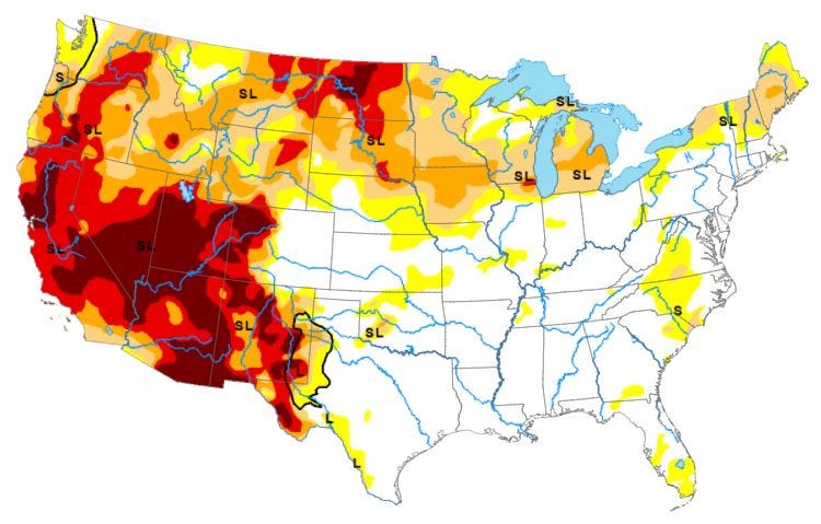
True to form, it appears as if the drought is stretching its tentacles to include the Midwest in its wicked little way. Exceptional drought has nearly swallowed North Dakota, and South Dakota is not far behind. Minnesota and Iowa are feeling the effects, and even a swath of Northern Illinois is getting in the game (so to speak).
The most recent US Drought Monitor map shows growing swatches of red and brown (extreme and exceptional drought, respectively), in the West. The recent heatwave in the Pacific Northwest is bound to expand the area in exceptional drought. The only place in the West not affected by drought seems to be the high country of Montana.
The Past to the Present
Cycles of drought are no stranger to the American Southwest.
Tree rings indicate generally drought-related conditions from 800A.D. to 1300A.D. They also help to identify “The Great Drought” from 1276 to 1299. The ancestral pueblo/cliff dwellers (the Anasazi) and the Hohokam tribes of Arizona were most affected. It is believed they migrated to areas such as along the Rio Grande where water was more predictable. Many of these “new” pueblos are still in existence.
In the West, the Colorado River is the lifeblood of millions from Wyoming to the Mexican border at Yuma, AZ. Its watershed extends hundreds of miles from the actual river with its countless tributaries.
Governors from the seven western states that use the Colorado River (WY, CO, UT, AZ, NM, NV, and CA) convened in 1922 to form the Colorado River Compact. It stipulated how much water each state would be apportioned from the river.
However, the compact was written during a time of abnormally high rainfall in the West. They couldn’t conceive of a megadrought, such as we are having now. Nor could they know that a village in southern Nevada would burgeon nearly three million people.
In 2007, new guidelines were put into place that expires in 2026. This includes a three-tiered system based on the water level of Lake Mead.
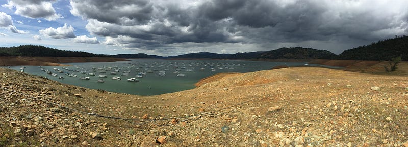
The surface of the lake, now at 1,075 feet above sea level, is the first threshold. It’s now fallen to 1,069 feet, so the first tier will go into effect in 2022. Tier 1 reductions will affect the lower basin states of AZ, CA, and NV.
The Central Arizona Project (CAP), a 336-mile long canal originating at Lake Havasu, was built to quench the thirst and support the growth of Phoenix and Tucson. It was also built for agricultural purposes, and farming will be the hardest hit. Water for agriculture will be cut by 65%. Residential use will see no reduction, but new and more strict water restrictions may go into place.
Most data agree that the American Southwest has been in a state of drought for most of the 21st century. Much of California has been in a persistent state of drought since 2000, with a slight easement in 2016-2019. The hardest-hit areas are all dependent on water from one source: the Colorado River.
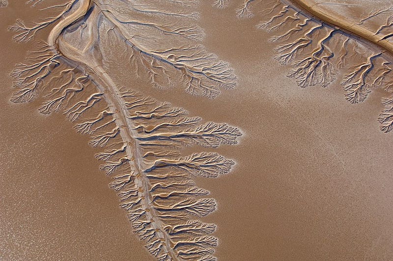
The river has been sliced and diced in too many ways, with an ever-growing population at its mercy. While the river would normally terminate in the Sea of Cortez in Mexico, Colorado River water has not reached the ocean since 1998.
This story doesn’t have a happy ending.
Built in 1950, the Morelos Dam is the last on Colorado’s long journey to the Gulf of California. It is used for irrigation in the Yuma area and the Imperial Valley of California.
But there’s not enough water left for Mexico. Its portion of the Colorado River is now absent of water and has been since 1998.
When the Glen Canyon Dam was built in 1966, water delivered to Mexico plunged. By the 1980s, most of the Colorado River Delta ecosystem was destroyed. Before it crosses the dam, water is diverted to farmland in the U.S. through a series of canals.
Stay tuned for Part 3. Learn how some of our largest cities in the West came to be and why they shouldn’t have been placed where they are!
Sources for this series come from Wikipedia, The U.S Census Bureau, NOAA, National Weather Service, Politico LLC-E&E News, Outside Magazine, Tucson.com, AZ Big Media.com, The Guardian, Science Magazine, Nevada Business, Las Vegas Sun, U. S. Water Alliance, and KUNC-Radio for Northern Colorado.