
THE MEGADROUGHT SERIES
How Will The Colorado River React To New Rules?
Chapter One — The Upper Basin
“Water problems in the western United States, when viewed from afar, can seem tantalizingly easy to solve: all we need to do is turn off the fountains at the Bellagio, stop selling hay to China, ban golf, cut down the almond trees, and kill all the lawyers.” ~David Owen, “Where the Water Goes: Life and Death Along the Colorado River”
A Primer on the River and the Megadrought
It’s been several months since my last story about the megadrought. Things on the river have changed in the short term, but not so much for its future. In case you missed it, here is a quick series reprise.
The Colorado River watershed is big — about 246,000 square miles big. That’s just shy of the size of the state of Texas. It is a lifeline for those living in the Intermountain West, flowing through seven states and two states in Mexico. It serves as the water supply for some 40 million people and power to states as far away as Nebraska by virtue of its two major dams at Lakes Powell and Mead.
In hydrology, the basin is divided into two areas: the Upper Basin, which comprises Wyoming, Colorado, New Mexico, and Utah, and the Lower Basin, which includes Arizona, Nevada, and California. While Native American peoples lived along the river for centuries, the white man did not fully explore it until John Wesley Powell’s expeditions between 1869 and 1871. Thus, the name Lake Powell.
Brigham Young and the Mormon settlers were among the first white men to settle near the river, creating what they called their own state of Deseret. They irrigated the arid Utah soil from small streams and rivers that would eventually reach the Colorado.
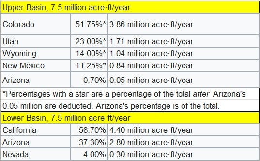
Seeing the river as a resource that needed to be managed as fairly as possible, the Colorado Compact was established in 1928, giving each state a percentage of the river, not necessarily based on what they were giving to the river. The amount of water flowing down the river was based on a historically wet era in the West. Thus, what was promised to each state began to fall short of their needs. Hoover Dam and Glen Canyon Dam were built to preserve water, generate power, and provide recreational areas.
Drought began to afflict the region in 2000, particularly in the Lower Basin states. Population growth began to outstrip the river’s supply. In 2007, a tiered system that dictated how much water could flow out of Lakes Powell and Mead based on the lake’s levels was implemented. Three tiers were established, and Tier 2a was reached in 2022. Tier 3 means “dead pool” — the level of the lakes is so low that water can’t flow out of them, and power ceases to be generated. Currently, the river has been rolled back to a Tier 1 shortage after a wet winter.
Water is measured by the acre-foot. One acre-foot of water equals the amount of water it takes to cover an acre, about the size of a football field, in one foot of water. One acre-foot of water equals 326,000 gallons.
If you’re going to look at the total flow of the Colorado River, you have to look at it holistically. It is highly dependent on the flow of its tributaries, which include the Green River from Wyoming, the Gunnison and Dolores Rivers in Colorado, the Gila and San Juan Rivers in New Mexico, the Virgin River in Utah, and the Little Colorado and Gila Rivers in Arizona.
Wyoming
“In Cheyenne, Wyoming, the frost-free season is barely four months. In such a climate, one can only grow low-value crops — alfalfa, wheat, and barley — which require much acreage to produce a meager income.” ~Marc Reisner, Cadillac Desert
Wyoming is the second highest state in the contiguous U.S., after Colorado. And its highest elevations are warming the fastest. Temperature increases affect snow melt, faster runoff, and greater evaporation, leaving less water for the Colorado’s most significant tributary, the Green River.
It’s not a great place to grow anything — mainly west of the Continental Divide. The main crop there is alfalfa, which is feed for livestock.
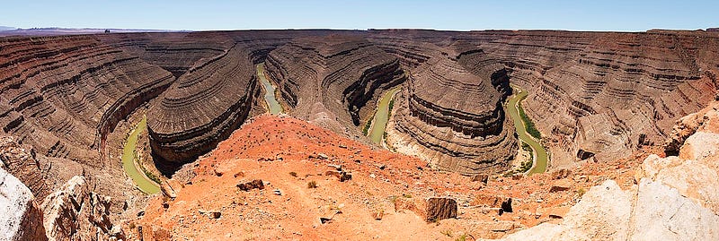
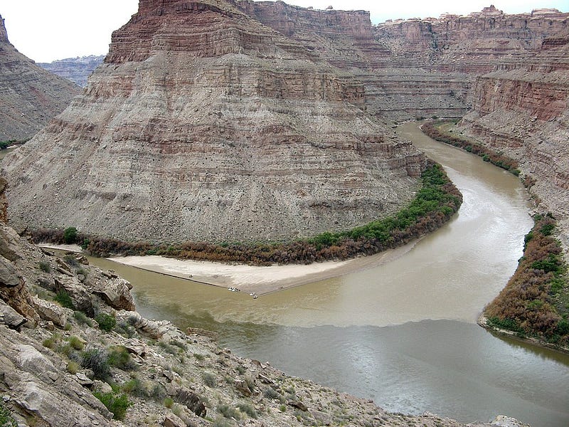
At the headwaters of the Green River, amidst seemingly abundant water with forests and mountains as far as the eye can see, it’s hard to believe what is occurring at the other end. Beginning in the Wind River Mountains of Wyoming, it catches up to the Colorado in Canyonlands National Park in Utah.
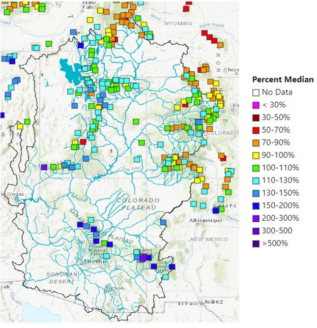
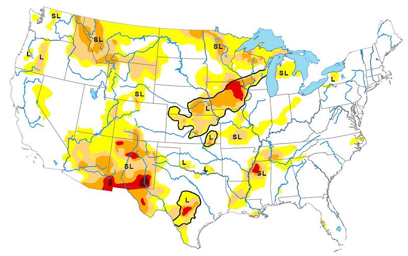
Portions of Wyoming are classified as abnormally dry, as determined by the U.S. Drought Monitor. That includes the headwaters of the Green, and the area has been steadily growing over the past three months. But as the fifth-driest state in the country, it is susceptible to drought. While 2023 was its wettest summer on record, it didn’t cancel out 20 years of drought.
Flaming Gorge Reservoir, the largest on the Green, starts in Wyoming with its dam in Utah. When the level of Lake Powell, straddling the Utah/Arizona border, came dangerously close to dead pool status in 2021, Flaming Gorge let 125,000 acre-feet of water out to help boost it up. It was worse in 2022: 500,000 acre-feet of water was released out of the dam to increase the level of Lake Powell. Thanks to last year’s bounty, Flaming Gorge bounced back and is now 84% full.
To prepare for emergencies downriver, the elevation of Flaming Gorge needs to be as high as possible. And that, of course, depends on the weather.
Colorado
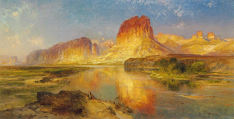
“The Colorado River rises high in the Rockies, a trickle of frigid snowmelt bubbling down the west face of Long’s Peak, and begins its fifteen-hundred-mile, twelve-thousand-foot descent to the Gulf of California.” ~Marc Reisner, Cadillac Desert
I wrote extensively about the headwaters of the Colorado River in 2023 in this story. The snowpack in Colorado’s Rocky Mountains plays a significant role in the river’s flow. Presently, the snowpack is above normal, and we have El Niño and the atmospheric river coming off of the West Coast to thank for that.
Other than from its tributaries, Colorado is the first and last place the river receives substantial flow from snowpack. The San Juan River provides some runoff from the mountains of southern Colorado and the Virgin in Utah, but other than that, the Colorado essentially flows through deserts. California does not contribute any water to the Colorado — its rivers flow directly into the Pacific Ocean.
Colorado’s various mountain ranges are either abnormally dry or, according to the drought monitor, in moderate, severe, or extreme drought. The latter classification is along the Rio Grande headwaters, which flows east of the Continental Divide to the Gulf of Mexico. But we’ll see its impact on the Colorado in the New Mexico section below.
As a child, I played on the banks of the Los Piños River in southwestern Colorado. It is a tributary of the San Juan River which joins the Colorado River at Lake Powell. To me, it is the most beautiful river, with pieces cascading down the forested ravines of the La Plata Mountains to create the whole and irrigate the lands below.I like to think that a piece of me and my dad is a part of the Colorado River. He would walk out into that swift river in waders and fish. I wanted to be out there so bad, but the rushing water took me right off my feet.
Three major dams on the Gunnison River — Crystal, Blue Mesa, and Morrow Point- contribute flow to help sustain the reservoirs downstream and did so in 2021 and 2022. But their levels plunged, and it was only because of the significant runoff from the 2022–2023 season that brought them back to near capacity.
The Bureau of Reclamation will continue to call on these reservoirs during lean times downriver, but Colorado officials argue that they are robbing Peter to pay Paul. They state that the lower basin states (Arizona, Nevada, and California) overdrew more than one million acre-feet of water between 2019 and 2021, and they shouldn’t have to bear the burden of future needs.
Meanwhile, the Front Range of the Rockies is calling. Seventy-five percent of Coloradoans live in the Denver and Colorado Springs metro areas, and at least 50% of their water is taken from the Colorado. With double-digit growth in many of the cities, the area will consume even more from the headwaters area of the river.
Utah
“The landscape everywhere, away from the river, is of rock — cliffs of rock; plateaus of rock; terraces of rock; crags of rock — ten thousand strangely carved forms; rocks everywhere, and no vegetation, no soil, no sand. In long, gentle curves the river winds about these rocks.”— John Wesley Powell
As the second driest state in the country, Utah’s contributions to the Colorado River are minimal. They include the Green River, which begins in Wyoming; the San Juan River, which originates in Colorado; and the Virgin River, which has headwaters just north of Zion National Park in Utah.
Relative to the rest of the Colorado’s tributaries, the Virgin is comparatively untamed. But it runs through a very sparsely populated area until reaching the city and metro area of St. George. This area has a huge straw in the Virgin, and based on the growth it wants to achieve, its needs are tremendous — so much so that a pipeline is being contemplated between Lake Powell and the city’s municipal water reservoir.
The Lake Powell Pipeline is forecast to cost up to $2.8 billion. There is an army of support for the pipeline — primarily developers, who want to see the city of St. George grow to a projected 425,000 by 2060. This will take the number of households from the current 62,416 to an estimated 203,901.
Lake Powell is already on life support. It is at 36% of capacity, or about 135 feet below its full pool level. According to the Bureau of Reclamation, the lake will get two million acre-feet less than initially thought this year. Lakes upstream will likely have to release more water than planned to keep Lake Powell at a sustainable level. A withdrawal as large as the Lake Powell Pipeline could devastate the lake’s future.
I went swimming in Lake Powell during a road trip in 2022. You see the “bathwater” stains in pictures. Until you’ve seen them up close, you have no idea of how monumental they are. How much water is gone.
But there are still contingencies that think building Glen Canyon Dam was a mistake and should be destroyed to restore the Colorado to a free-flowing river. These are primarily environmental groups. Of course, that would kill all notion of a pipeline.
This kind of growth assumes that the pipeline will be built, according to the University of Utah’s Long-Term Planning Projection Summary. Thirty percent of St. George’s economy is attached to the building industry. “If growth stops, our economy would be killed overnight,” said St. George Mayor Michele Randall.
Deep water wells are being drilled far outside the city limits, threatening the water supplies of smaller towns.
To learn more about St. George and why it was a stupid place to build a city, click here.
“The Colorado has no more water to give” ~Zach Frankel, executive director of the Utah Rivers Council
New Mexico
“Until I came to New Mexico, I never realized how much beauty water adds to a river” ~Mark Twain
You might be wondering why New Mexico is part of the Colorado River equation since it is the only state through which the river doesn’t flow.
Well, it’s because it has a major tributary feeding into the Colorado, the San Juan River. Further south, it’s the Gila River, though it is often dry by the time it gets to the Colorado, except during the monsoon season.
The river begins high in the San Juan Mountains in southwestern Colorado. It flows southward to New Mexico, where it is dammed at Navajo Lake.
Navajo Lake is another area where my Dad would fish. I never fished because I was terrified of taking the fish off the hook, yet I had no fear of hunting down snakes and other reptiles, amphibians, and bugs of all sorts.
The San Juan continues after the dam, running through the northwestern part of the state, passing near the Four Corners, then flowing through southern Utah until it ends in an arm of Lake Powell. The San Juan is known as one of the muddiest rivers in the country, and it contributes so much sediment once it reaches Lake Powell that it has formed its own delta.
In return, New Mexico gets 11.5% of the Upper Basin’s allotment of water.
Ninety-six percent of the state is currently in some stage of drought. Southeastern New Mexico is the hardest hit, including the cities of Roswell and Carlsbad along the Pecos River and in the northwest, including Farmington. Much of New Mexico depends on the North American monsoon to fill its rivers and reservoirs. We call the 2023 season a “nonsoon.” It failed to materialize.
Water from the Colorado River is diverted through pipelines to the Rio Grande via the San Juan-Chama project. Thus, the cities of Albuquerque and Santa Fe depend on the Colorado River for their drinking water. Seventy percent of Albuquerque’s water comes from the Colorado via the Rio Grande. Without the pipeline, the Rio Grande would go dry even more often than it does now. It ran dry north of Albuquerque in 2022.
Albuquerque is my home of five years, and the valley in which it resides is in a rain shadow. With the absence of the monsoon last year, we’ve had all of 6.5 inches of rain since the start of 2023 — less than Las Vegas’ 12.12 inches, and on par with Phoenix’ 6.31 inches.
While the snowpack in New Mexico’s mountains is above average, don’t count on it to end the drought anytime soon. A coming long period of above-average temperatures and low precipitation could spell another year of torment for the state. High temperatures will quickly melt the snowpack, whereas the ideal situation is a slow drip into the summer.
Conclusion
The Upper Basin is a holding area for water downstream. It wasn’t meant to be the life preserver, but the Lower Basin’s needs continue to drain its resources as climate change marches forward.
My fear is complacency. With two years of wet winters under its belt, California may forget about conservation — and it is the biggest single user of the river. Both Lakes Powell and Mead are only one-third full. The reality is under the current scenario, they will probably never be at total capacity again.
As the Upper Basin is the most significant contributor, the Lower Basin is the primary user. With the expiration of the Colorado Compact, how the river gets divvied up from here is anyone’s guess. Still, it will take a lot of cooperation between the states and conservation among its users.
Next, we’ll look at the Lower Basin, how El Niño lived up to its name, and the situation on the two largest lakes.
But the fed's decisions will be key.
Sources for the series include:
- “St. George, UT Will be Among the Fastest Growing Cities by 2060” by Samuel Stebbins on 24/7WallSt.com, 9/16/2022
- “Threat of massive drinking water crisis looms over American regions: ‘There will be parts of the U.S. that run out’ by Wes Stegel in TheCoolDown.com, 11/27/2023
- “Push to drain Lake Powell gaining momentum” by Greg Haas, KTLA News Los Angeles, 9/18/2023
- “Saving the Colorado River: An acre-foot at a time in the Upper Basin” by Joi O’Donoghue in the Salt Lake Deseret News, 12/21/2023
- “The Colorado River 101” by Jan Pelz on grandcanyontrust.org, 5/16/2023
- “Wyoming climate data holds ominous clues about life, economy” by Dustin Bleizeffer on energynews.com, 11/3/2021
- “It was the wettest summer on record for Wyoming — what does this mean?” by Caitlin Tan, Wyoming Public Radio, 10/5/2023
- “In America’s fastest growing metro, a rising fear water will run out” by Karen Bruillard in The Washington Post, 8/22/2022
- “Colorado’s Blue Mesa Reservoir still part of plan to keep water levels at Lake Powell from falling too low” by Shannon Mullane in the (Denver) Colorado Sun, 10/24/2023
- “Dozens of Colorado farmers, ranchers and one city offer to cut Colorado River water use in exchange for $8.7M,” by Shannon Mullane in the (Denver) Colorado Sun, 2/13/2024
- “Here’s what feds think will happen with Lake Powell’s water level this year” by Anastasia Hufham in the Salt Lake Tribune, 12/30/2023.
- “A Dwindling Mighty River” by Nadav Soroker in Searchlight New Mexico, 9/21/2023
- “Water Security on the Navajo Nation” presentation created for the Department of the Interior, OEPC.
Earlier stories on the Megadrought by Arthur Keith:


