
Ukraine War
Ukraine: Satellite Surveillance and Communication
This war has not only been about drones, cellphones and open source intelligence, it has been about satellites
In February 2022, wired.com reported that there were 50 satellites in use over Ukraine. That picture has changed somewhat since then and we’re over six months into the conflict.
In this story I’ve taken a look at the subject of satellite usage in a bit more depth, covering government/military and commercial satellites over the Ukraine theatre of war. If you’re interested in the ‘ethical’ policy aspects of commercial companies selling their satelite image data to belligerents, then the Wired article covers it well.
Database of satellites
The Union of Concerned Scientists (UCSUSA) maintains a database of satellites in orbit and as of May 2022 reported that there were 5,645 in orbit around the Earth.
This database will grow hugely, given that Elon Musk’s Starlink expects to have 48,000 in its final constellation — it currently has clearance to deploy approximately 12,000 of its low-orbit satellites, a big increase from the initially approved 4,400 satellites. The company has filed requests for additional approval to launch another 30,000 of its broadband satellites. Currently, it has about 2,000 in orbit.
There are other satellite web providers too such as OneWeb (470 in orbit) which is struggling to find launchers since its Russian launcher of preference is out of the picture.
Elon Musk’s network is being well tested in Ukraine where he has donated several hundred Starlink terminals. The Starlink satellite constellation has enabled Ukraine’s military to maintain secure communications while the Russians have been using public network cellphones. It has also enabled the public to feed targeting data from cellphones via Telegram and other channels. Open source intelligence has taken a new shape.
Yes, sate️llites both military and commercial are hard at work in the Ukraine war, but most of them are on the side of Ukraine.
Ukraine ‘buys a satellite’
Ukraine has bought satellite access on the ‘open’ market.
Serhii Prytula, a Ukrainian volunteer and TV presenter, reported that a satellite was bought with funds from the “People’s Bayraktar” campaign
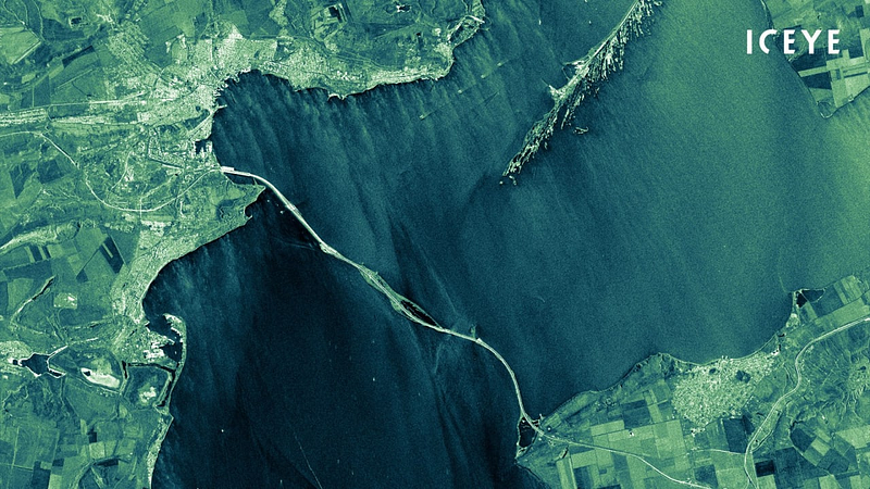
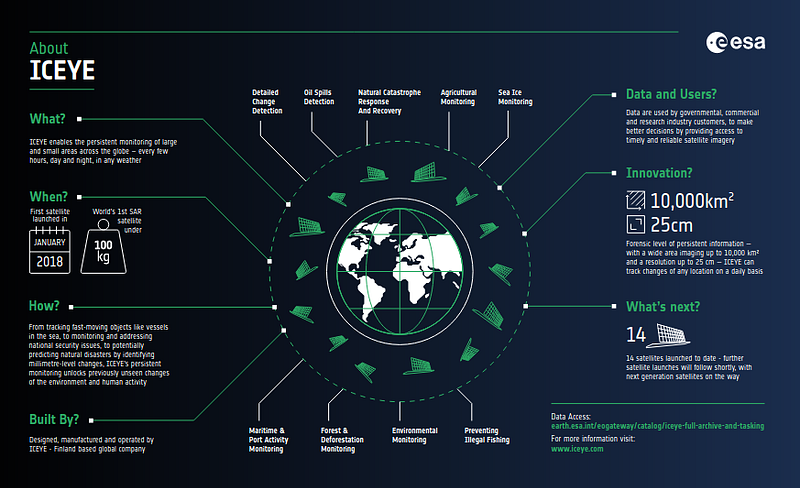
It provides access to the ICEYE Company’s constellation satellite imagery database.
The access was bought for more than a year.
Now the Armed Forces of Ukraine will quickly receive satellite images, which will help to destroy the enemy most effectively.
It will be recalled that it’s concerned 600 million hryvnias, which the Ukrainians have collected for the purchase of “Bayraktar” UAVs. — Ukrainenewenglish
That’s about US$16.25 million.
Each ICEYE satellite is in a sun-synchronous orbit with a nominal 1–22 day ground track repeat cycle (depending on satellite) with 15 imaging orbits per day. Each orbit plane is phased around the Earth with a different local time of ascending node (LTAN) and descending node (LTDN). This means that the constellation as a whole has the ability to observe a location at different times of the day rather than the more conventional dawn-dusk sun-synchronous orbit. — source: ICEYE
‘Ukraine will receive a satellite operating in orbit with an easy-to-observe inclination’.
Data is typically updated every few hours making it possible to observe combat operations at a tactical level, albeit not in real time.
Image Resolution
ICEYE Group satellites observe the Earth in the microwave range (SAR) — this allows them to take images of the surface at any time of day and under any weather conditions. Image resolution is 25 centimeters per pixel.
Other commercial satellite companies like Maxar and Planet typically have a maximum resolution of around 15 centimeters.
The United States Government has at least five Keyhole-12 satellites, the UK, Italians, the French and the Spaniards have their own satellites with imaging capabilities thought to be an order of magnitude better, according to Bart Hendrix (a Brussels-based analyst and expert on Soviet and Russian space programs) in an interview with rferl.org.
The best American Keyholes are estimated to have a resolution of around 5 centimeters per pixel (but do we really know)? Russians paint the letter “V” on the roofs of their military vehicles operating in Ukraine. That would be easily imaged by a Keyhole.
Russia’s use of Z and V symbols has been used interchangeably, with ‘V’ also used in graphics to stand for ‘victory’ in Putin’s military campaign.
But it has also been closely aligned with the phrase “Сила правде” meaning “Power of Truth” and “задача будет выполнена”, which means “the task will be completed”. — The Scotsman
Thermal imaging is important too, as tanks even under camouflage cover will show a slight temperature differential.
But resolution isn’t everything
High-resolution is often associated with high-accuracy (and vice versa), but this is not always the case.
When a satellite sensor captures an image, a positioning device on the satellite computes its orbital position relative to the earth and stores that information in the metadata for that image. The accuracy of the positioning device is related to the absolute accuracy of the captured image. Since satellites orbit 500km above the earth at a speed of more than 20,000km/h, the positioning device needs to be very sophisticated to be accurate. — intermap.com
Typically, intermap.com says that a commercial satellite with a resolution of 31 cm will have a positional accuracy of 5 m. That’s probably accurate enough for military targeting, but would not easily allow identification of a target.
What about Russian satellite capability?
Hendrix continued “In principle, Russia is already practically blind in orbit”.
Russia is thought to have about 100 satellites in orbit, according to the UCSUSA database I downloaded in Excel format. You can too if you’re really keen at https://www.ucsusa.org/resources/satellite-database. It’s currently about 2.8 MB in size.
Nineteen of the hundred are classified as remote sensing satellites, with capability for optical photography or radio signal surveillance.
It has two Persona optical imaging satellites — Cosmos 2486 and Cosmos 2506. They were launched in 2013 and 2015 and are near end of life. Resolution is thought to be 50 cm per pixel according to Hendrix.
Russia has radar and thermal imaging satellites as well.
Note: Since February 2022, it seems that the US Air Force has launched ten more satellites (USA-327 through to USA-336) several with ‘unknown purpose’. That’s according to Wikipedia. These are not yet recorded in the UCSUSA database (as of 24 August 2022).
Is Russia desperate?
It must be. Putin recently visited Russia on a drone shopping expedition and soon after it was announced that Russia would partner with Iran to produce satellites. And buy drones.
Iran plans to launch satellite production jointly with the Russian Federation. Iranian Minister of Communications and Information Technologies Eisa Zarepour stated this at a press conference in Tehran, IRNA news agency reported
“The day before, the Khayyam satellite, manufactured by Russia on order from Iran, was launched from the Baikonur Cosmodrome in Kazakhstan. It was launched into orbit by a Soyuz launch vehicle. Iran will create a joint production with the Russian Federation of the second, third and fourth versions of this satellite,” Zarepour said.
Iran claims that the satellite will be used exclusively for civilian purposes — to monitor the environment, but the West expects that Russia will use Khayyam to obtain information about Ukrainian military facilities. And Tehran will monitor Israeli targets. — Ukrainenowenglish
Khayyam is is named after the brilliant Persian poet, astronomer and mathematician Omar Khayyam (Rubaiyat). It is a Russian-built Kanopus-V Earth-observation satellite that can resolve features as small as 1.2 meters on Earth’s surface, The Washington Post reported.
“That’s far short of the quality achieved by U.S. spy satellites or high-end commercial satellite imagery providers, but a substantial improvement over Iran’s current capabilities,” The Washington Post continued.
“Potentially the most significant benefit,” the newspaper added, quoting unnamed Western intelligence officials, “will be Iran’s ability to ‘task’ the new satellite to conduct continuous surveillance on locations of its choosing, including military facilities in Israel, oil refineries and other vital infrastructure in neighboring gulf states.”
According to experts and open-source information compiled by RFE/RL, Russia has for a long time struggled with a small, poor quality assemblage of communications and surveillance satellites that use old technology or imported components now embargoed by Western sanctions.
How times have changed!
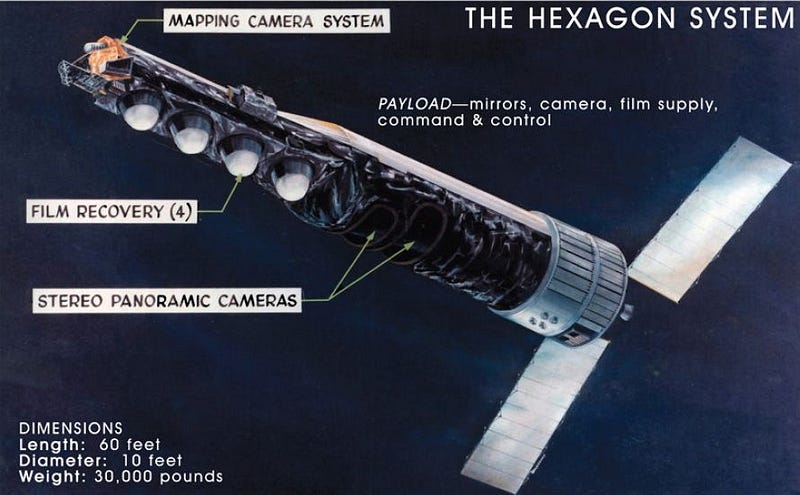
Even before I was using dial-up modems for email these early bus-sized Hexagon spy satellites were in an orbit which was 170 km above the Earth at its nearest (perigee). The photographic film from the cameras was sent within the satellite to recoverable re-entry vehicles and dropped to Earth, where the capsules were caught in mid-air by an aircraft. Four re-entry vehicles were carried on most missions, with a fifth added for missions that included a mapping camera.
Today you’re probably reading this on a gigabit web link while the guys in the satellite control centres are watching full colour Russian troop movements in almost real time with less than half a second latency.
Therein lies a problem.
Higher resolution means that higher bandwidth is required if the data is to be accessed in near-real time. The satellites have to scan large areas in high resolution. I don’t know whether they have ‘spotter’ functionality (as in sniper teams), but the amount of data is significant and it’s not downloaded in film canisters. Ground stations are required.
It’s believed that Russia’s data processing capability is well behind that of the US and other countries. To be really useful the data has to be fed to target designators as quickly as possible. Timings vary — an ammunition dump cannot be quickly relocated and we’ve seen that Russia has lost a lot such sites over the last few weeks. But tank columns can move significantly in short periods.
Here’s the process as I see it from my amateur armchair:
Satellite — download — analyse — identify — communicate (US to Ukraine command) — validate not civilian — targeting priority — add to target roster—select weapons system (probably HIMARS) — execute.
Computers are used extensively, no doubt, and AI as well. There will be differential image analysis to detect what’s changed since the last pass— that’s the quickest way and easy for computers.
The law
By international law, a state “has complete and exclusive sovereignty over the airspace above its territory”, which corresponds with the maritime definition of territorial waters as being 12 nautical miles (22.2 km) out from a nation’s coastline — Wikipedia
The US U2 spyplane has been in service since 1956. Two have been notably shot down — the Gary Powers incident (70,500 feet high over Russia, 1960) and the one over Cuba in 1962 (72,000 feet). These were clearly deemed to be in controlled airspace. They were being used because the quality of satellite imagery at the time was not as good as those of the cameras in the U2.
But it’s a grey area in law.
There is no international agreement on the vertical extent of sovereign airspace, with suggestions ranging from about 30 km (19 mi) — the extent of the highest aircraft and balloons — to about 160 km (100 mi) — thought to be the lowest extent of short-term stable orbits, disproved by the satellite Lixing-1 having a stable orbit with an apogee of 140 km (87 mi) for three days. — Wikipedia
The US’s Keyhole 6 (aka KH 12–6) has an perigee (nearest orbital approach to Earth) of 200 km in an elliptical orbit, with an apogee of 1,000 km. In contrast, a Starlink satellite has only 3 km difference between its apogee and perigee. Yes, there’s plenty of interesting data in that database.
Anyway, it’s a commonly held view that any attack on a country’s satellites is an act of war. China and the US have recently been testing each other in orbit.
However, it depends what is meant by attack. There is a continuous space war going on in cyberspace, with countries testing the cyber defences of other countries’ satellites. It seems that cyber attacks are accepted despite the rant of the recent head of Roscosmos, Dmitry Rogozin (fired by Putin), but physical attacks would cause a war.
“…blinding nuclear command and control or early warning satellites could be very destabilizing.” — politico.com
It’s getting very crowded up there.
And dangerous.
A step too far
I’m sure that Putin would love to block those Keyholes and disable the commercial satellite networks, but that would be a step too far.
He knows it and that is why he wants to get his hands on Iranian satellite capability. He’s running out of time.
A rock and a hard place.
When it comes to identifying arms dumps or fixed installations deep in enemy held territory, drones are too vulnerable. Satellites are much better.
Watch this space…
About me: If you follow me I guarantee variety in your inbox with some unusual perspectives! I write on a wide range of topics including humor, tech, space, geopolitics and travel, together with daily news events and the minutiae of my daily life living on a boat. Yes, I really do live on a boat (some readers don’t believe that). I also write about…
…spy in the sky
If you appreciate stories like these and want to support other writers and me, consider signing up to become a Medium member. It’s only $5 a month, giving you unlimited access to incredible stories on Medium. If you sign up using my link below, I’ll earn a small commission at no extra cost to you.
Or maybe just buy me a coffee? and tell me what you liked reading (or not)!
