
The skin of Earth
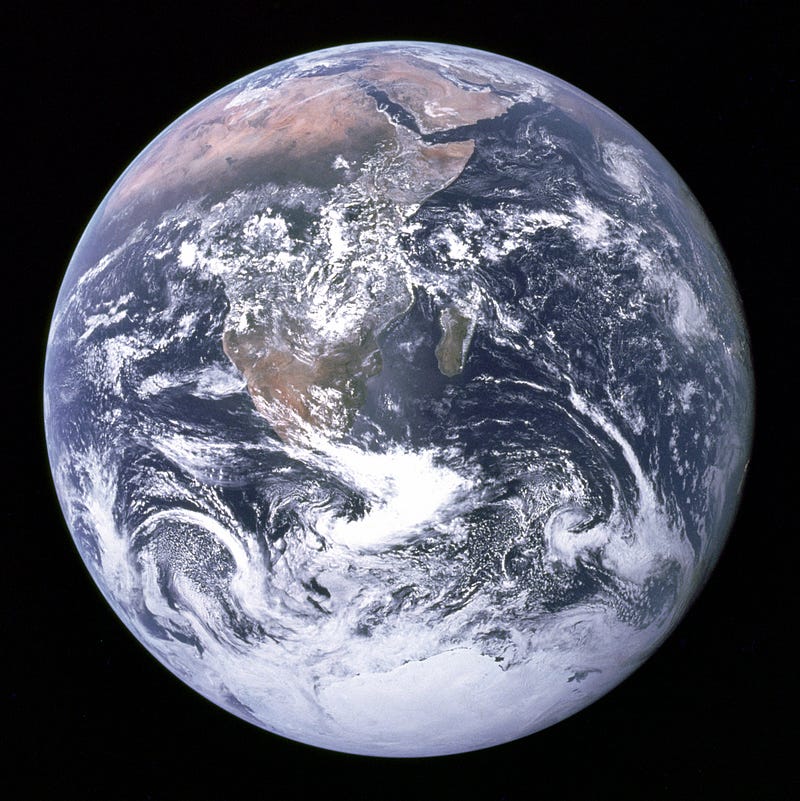
On the 7th of December 1972 was taken the first picture of the Earth. This picture was taken at a far distance and gave to the viewer a general impression of what the Earth look like.
It’s round and blue.
Besides the striking ocean; the African continent, the Antarctica and some clouds are visible as well.
This was 50 years ago. Now, technology has largely improved and we can have more detailed pictures of the Earth. Many satellites are turning around our blue planet and take pictures of its surface everyday. These high-quality pictures put together can identify the land cover of the Earth.
What on Earth are land covers?
Land covers are exactly what they sound like. The cover of the land. The skin of the Earth.
It’s the description of the elements at the surface of the Earth, for example vegetation, water and build-up areas. Land covers have a direct effect on the functioning of the Earth system.
A land covered by a forest doesn’t have the same temperature or water cycle as a bare land. An area covered by building (e.g., a city) physically doesn’t behave the same way as an area covered by crops like corn or wheat. These various land covers have different rate of water evaporation, sunlight reflection, and temperature absorption.
Land covers are also a proxy to determine other land properties like biodiversity or carbon content. Obviously, a primary forest stores more carbon and contains more animals’ species than a crop field or a city.
Human population is growing and more importantly people are asking for more goods and resources from our planet. To develop new crop plantations, mines and cities, it’s crucial to plan carefully and spare the pieces of land which are important for biodiversity and carbon storage. It’s better to plant crops on a bare land than on a forest. It’s better to spare species rich habitats when expanding cities.
The art of categorizing
Defining land covers is about creating categories and finding ways to differentiate them. Seeing the difference between a forest and a city is easy, even from space. It becomes trickier when you want to differentiate primary forest, secondary forest and tree plantations (e.g., rubber, oil palm). From space, these three land covers look green and bushy…
Mutually exclusive land cover categories are not easy to create. On the one hand, we are limited by our language or mind. For example, it exists four words in Indonesian to name a degraded forest, each word corresponding to a different degree of degradation. In English, we lack these words and therefore these categories.
On the other hand, there is a lot at stake when defining the word “forest”. For example, many tree growers would like their plantation to be qualified as a forest and thereby hide the negative environmental impact of growing one species of tree on a large area (e.g., acacia, oil palm).
A Selfie of Earth
The Blue Marble from 1972 gives few information about Earth’s land cover. From the picture, we understand that Earth is mainly covered by oceans, but we know almost nothing about what’s covering the continent.
Nowadays, satellites are closer to the Earth and can take pictures of high resolution where I can see my house. For example, Landsat satellites have a resolution of 30 square meters which means that each pixel of the picture represents a square of 30 meters on the ground. Other satellites like SPOT have a resolution of 1 square kilometre.
Higher is the resolution and slower is the satellite to turn around the Earth and take a complete picture of its surface. Landsat can take a complete set of the whole Earth land cover in 16 days, while SPOT can take this same set of pictures twice in one day. There is a trade-off between space resolution (size of pixel) and time resolution (revolution time).
Each picture of the Earth will contain many pixels. Two pictures can overlap and both include identical pixels. Since it’s not convenient to duplicate the information, Earth pictures are processed, duplicated pixels are deleted, and filters are applied. It’s like editing a selfie on Instagram but in a more complicated way.
A selfie of the Earth taken by a satellite is called a “tile”. All tiles put altogether side by side can give a complete picture of the Earth land cover.
Classifying land covers
Since the Earth is big and its tiles contain many pixels of 30 square meters, the classification of its land cover cannot be done by hand. And even if the land cover classification is done at a small scale like a country-scale, it’s cheaper and more efficient to automatize everything.
Classification can be supervised by human or not. In case it’s supervised, a human being must determine land cover classes such as forest, city, crop land, sea… and tell the classifying algorithm ‘hey dude, these pixels I am showing you are forests, find all similar pixels and group them as forest; these are cities, groups them as city; etc…’
For the unsupervised classification, the algorithm directly groups similar pixels together without any assistance. The researcher later gives a label to each group (e.g., forest, urban, water…).
Each classification type has it advantages and drawbacks: costs, time, precision… A variety of algorithms have been developed for each classification type. To facilitate the job of the classifying algorithm, it’s important to make pixels different from each other’s.
Satellite sensors get information from the light reflected by the Earth surface. They sort out this information by bands similar to the strip of a rainbow. For example, Landsat’s sensors can sort out the light into 7 bands including ‘red’, infrared’, ‘green’ etc… Once this information is sorted out, it’s possible to calculate values such as vegetation indices and texture values. These indices and values are calculated with a bunch of formulas that I won’t review here because it’s boring. The key idea to remember is that those indices and values help to differentiate pixels from each other. Theoretically, more indices and values you have and easier it is to differentiate pixels. More details you have about a person and easier it is to spot it in a crowd of people.
Once all pixels have its set of characteristics (e.g., bands, indices and textures), the classifying algorithm can recognize the differences between pixels and easily group them. The algorithm gives the right label to each pixel and draw a colourful map with a legend of the land cover classes. Looking at the map, you can say: ‘Hm, there is a lake here’ or ‘Oh God, farmers have expanded their cropland into the forest without telling me!’
The truth on the map
Once the map is created, how to make sure that this image of the world is true and not the artistic creation of a childish algorithm?
To check if the algorithm has classified the land cover well, it is possible to make it sort out areas of which we already know the land cover.
Before running the algorithm, it’s possible to go on the field and check the land cover of a defined area, and take photos or videos. For large areas or lazy scientists who do not like long hikes in the forest and the countryside, it is also possible to identify land cover with satellite imagery. It is not as reliable as a ground truth, but for large areas it is more realistic and cheaper.
Once you have identified and labelled the land cover of known pieces of land, you can run the algorithm and check whether it is doing well.
Scientists usually organize the mistakes of the algorithm on a table and check which land covers were confounded. For example: ‘plantations were often identified as forest by the algorithm’ or ‘bare ground was identified as water by the algorithm’.
Checking which land covers the algorithm struggled to identify give valuable information to improve the classification later. Scientists can either improve the algorithm or sample better training and testing areas. They can also choose images from other satellites or calculate different vegetation indices etc…
Once you have created a map and know how accurate the classifying algorithm is, you should compare the map with other available maps or land cover data. Having a map concurring with land cover data or other maps is a good way to ensure its trustworthiness.
Take home message
Watching the Earth from space is important to have a global picture of what is covering our blue planet. Of course, there is water in the ocean, but the land cover of the continent is also a key component of the Earth system. As human beings are completely changing the appearance of the Earth, moving its skin, putting some make-up here and there, satellite imagery and remote sensing are great tools to ensure that we are not messing up its natural beauty!


