
Best Foot Forward
The secret signage system walkers use to stay legal when roaming the English and Welsh countryside
Ah, the great British countryside! Rolling hills, beautiful streams, and an angry bull chasing you at thirty miles an hour!
Believe it or not, this relatively tiny island we call Great Britain has over 140,000 miles of footpaths crisscrossing its diverse landscape. Actually, I lie. There are 140,000 miles of paths crisscrossing England and Wales. Scotland has a different set of regulations for exploring the countryside (more of which, later).
It struck me while reading Adrienne Beaumont’s Lost in Translation that even though some signs lose something in translation we can usually work out what they really mean, but what if you don’t know that there is a signage system in the first place? How can you truly appreciate the information a sign is offering?
If ever you fancy going for a stroll in England and Wales, it’s worth looking out for the signs, or waymarks, for they reveal a lot about what you’re walking on and, therefore, what you can and can’t do. (Intrigued? Good!)
Rights of Way
First of all, if ever you’re going for a walk in the UK, take a map. The Ordnance Survey (OS) maps are the best in the world. Don’t even think about disputing this — they’ve been making them for over 200 years, mainly because we needed to know what our land looked like in case Napoleon fancied invading. (He didn’t, but if he wanted to now, he’d definitely buy a copy of the OS maps for the areas he was going to attack.)
For a guide to all the symbols found on an OS map, check out their key here. If you do, you’ll see one of the most important symbols are those relating to public rights of way.
That’s right. What we walk on here in England and Wales are not paths, but rights of way. There’s a subtle distinction. You might see a path on the ground … but if it isn’t a legal right of way, then you’re not legally permitted to walk along it. It’s probably a sheep track. Which means you are trespassing. (Not a criminal offence, but heaven help you if you cause any damage, because you could still find yourself in court.)
Similarly, just because a line on the map shows there is a legal right of way across the ground, it doesn’t actually mean that it’s physically possible to walk it!
Of course, as this is Britain, we have a class system regarding rights of way, and this is where knowing your signs comes in handy.
First, let me introduce you to the humble …
Footpath
Now, brace yourself for this, a right of way designated as a footpath gives you the right to walk across the land on foot. But only on foot. Amazing, heh?
Actually, it’s a little more nuanced than that. You can walk along a footpath, on foot. You can also push a pushchair along a footpath (although I would strongly advise you not to bother because many footpaths are muddy, or strewn with boulders, or after heavy rain nothing more than a stream of six-inch deep water).
You are also permitted to have a picnic (but don’t block the right of way, for that incurs the wrath of the local authority). You can also take photos from a right of way, such as a footpath. (This is why, in Britain, whenever a celebrity stays in a rural hotel, photographers from some of the tabloid newspapers suddenly take up an interest in exploring the nearby rights of way.)
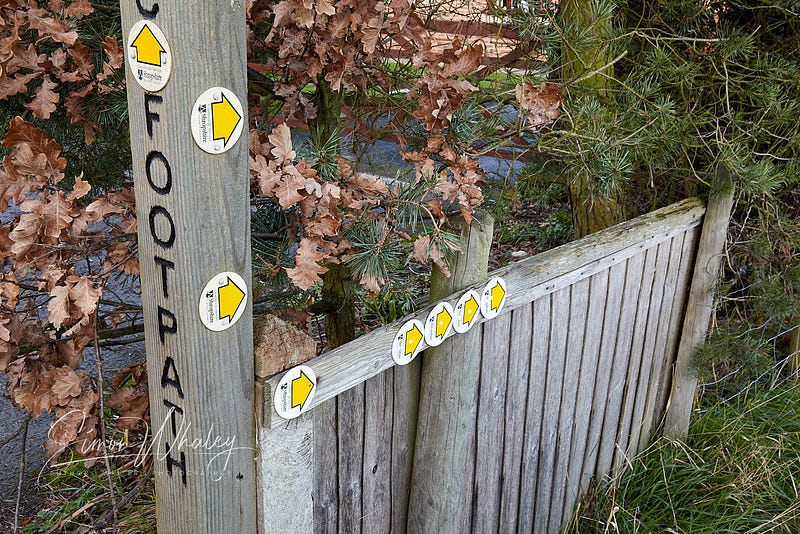
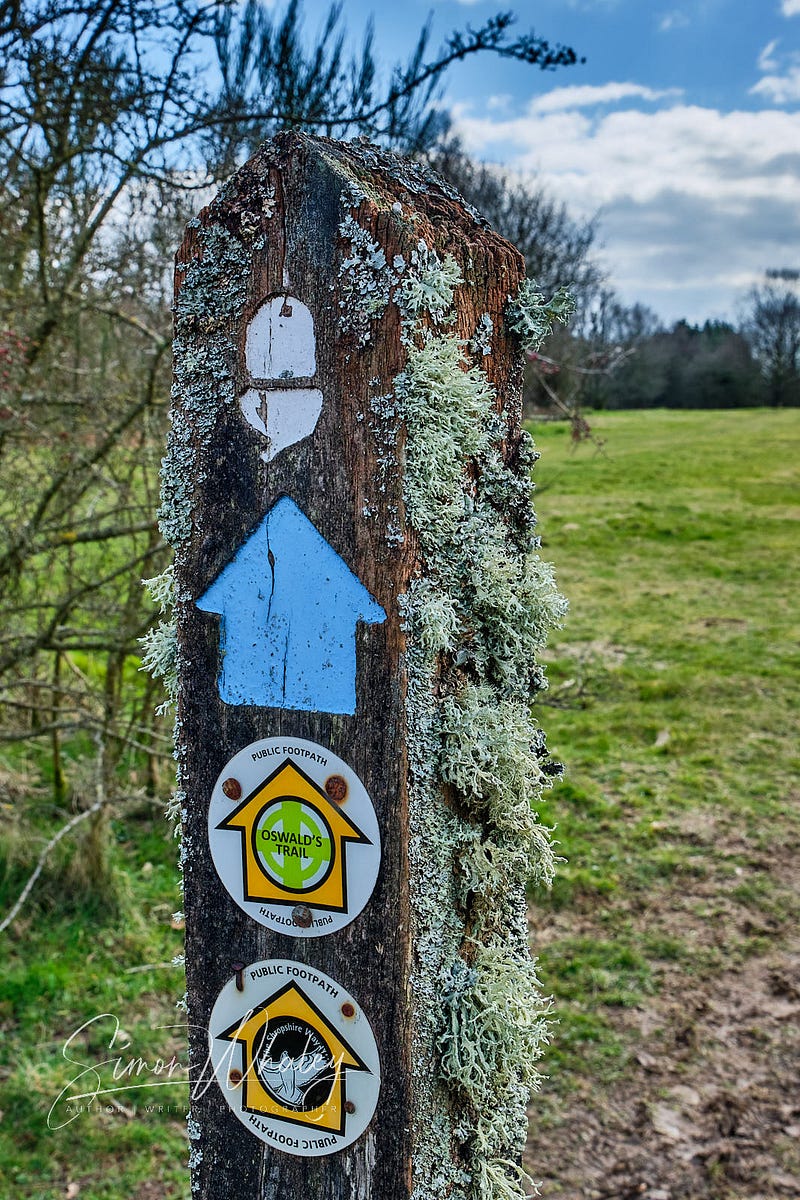
Now, it makes sense for footpath signs to be in the shape of an arrow to help point you in the right direction. But these signs also have a colour-coding system, too. Clever, huh? A footpath will be signed with yellow arrows.
So, if you see a yellow arrow, then you know you’re on a footpath. (You might still be lost, but at least you know you’re on a legal right of way.)
Actually, if you’re following a map and you see you’re on a footpath and the map shows it as a bridlepath then you know you’ve made a navigational error. (One is never ‘lost’. Proper hikers are only ‘temporarily misplaced’.)
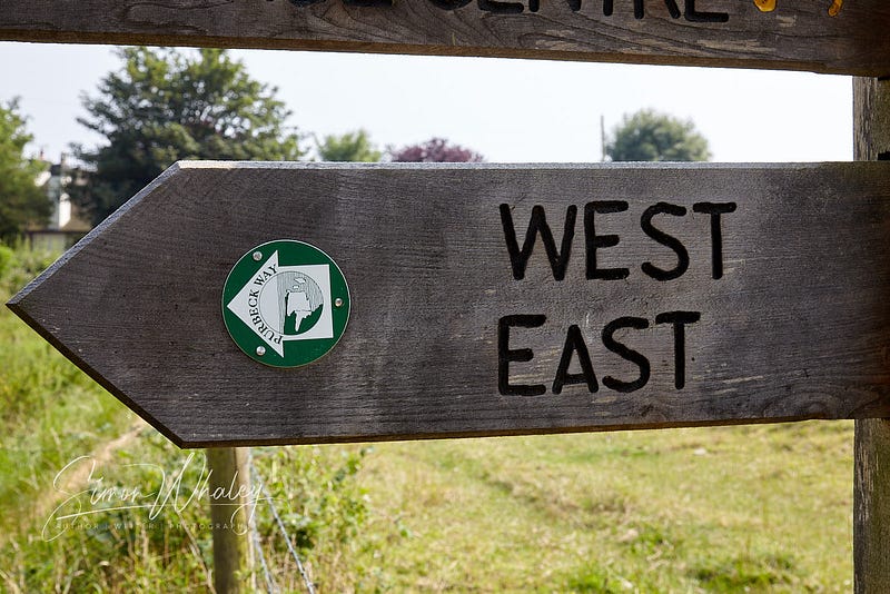
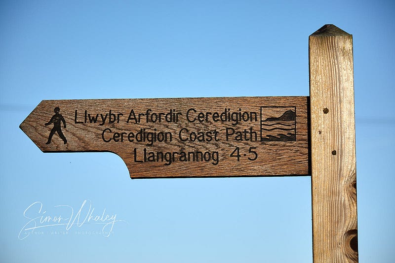
Some routes have names, such as Oswald’s Trail or the Shropshire Way (see photo below), and as such, that often warrants a logo, too. But if the local authority rules are followed, the logo should still sit in an arrow of the right colour.
The next class of right of way is called a …
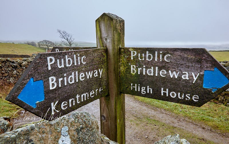
Bridleway
(You may also hear it referred to as a bridlepath.) Now, the intelligent readers will be ahead here, I’m sure, but don’t get too cocky. A bridleway can be used by horse riders. But not just horse riders. (See? I told you not to get too cocky, didn’t I?)
A bridleway is for foot power. Now, that foot power could be coming from your feet. As a solitary walker, you are foot-powered, so you can walk on a bridleway.
If you happen to be sitting down on a horse, then the horse is moving you by the power of feet (or hooves), so horses can use bridleways, too. But there’s another situation in which you might be sitting down, yet still moving, and that’s when you’re cycling. Because your bicycle is powered by only your feet, you can use a bridleway, too.
Any wheeled device that uses some sort of engine to propel it forward (or backward) cannot be used on a bridleway.
The sign to look out that denotes a bridleway is a blue arrow.
Finally, there’s a third class of right of way (as far as walkers are concerned) and that is a …
BOAT
Okay, okay, okay, I know this is confusing. How can a footpath be called a boat? The answer is when it’s an acronym. A BOAT is a Byway Open to All Traffic.
It is what it says on the tin. It’s a right of way that anyone can go down in any form of transport they see fit. So if you fancy going in a boat on one, then by all means go for it, but don’t expect to get very far.
BOATS can be used by walkers, cyclists, horseriders, and users of any mechanically-propelled vehicles, such as a motorbike, car, lorry, juggernaut, space shuttle, or whatever.
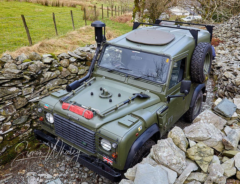
But cast your mind back to the beginning of this piece, where I mentioned that just because a right of way is labelled as such, it doesn’t mean you can physically do it … as this chap found out in the Lake District …
Because the B in BOAT stands for Byway, some local authorities call them Byways, rather than BOATs, but they will all use the colour red to denote that this legal right of way is open to all types of traffic (probably because of the bloody carnage caused when a motor vehicle suddenly appears around the corner when everyone was least expecting it.)
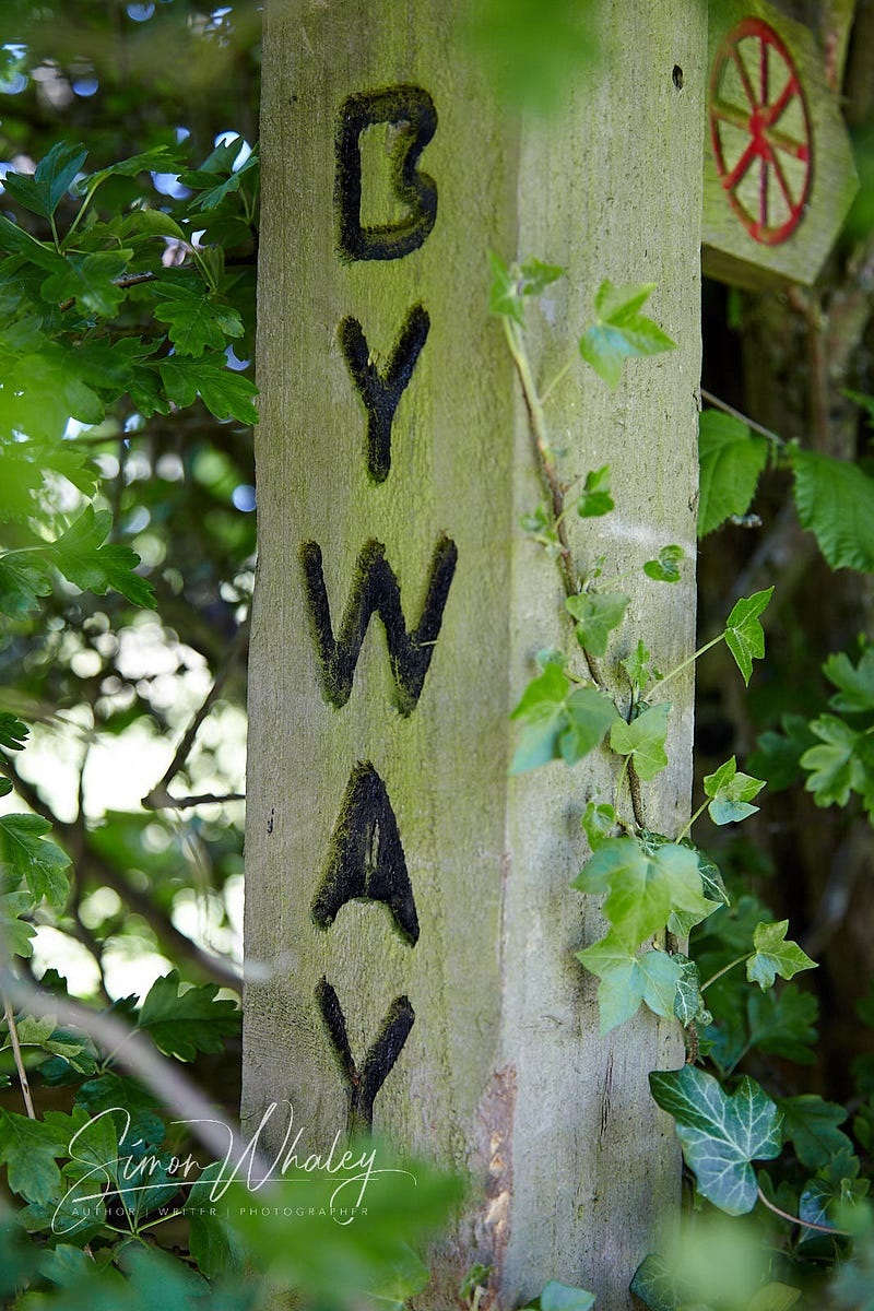
But now you know that a BOAT means anything motorised can use the route you’re on, at least you know. Red means danger.
There’s another class of footpath that the Ordnance Survey maps show that is not a legal right of way. Let me introduce you to …
The Permissive Path
Right, I know what you lot are thinking, and you can pack it in right now. This isn’t anything rude (oo-er missus), but a temporary form of footpath.
Some landowners out there are really nice and so they create a path or track that they allow walkers to use, even though we have no legal right to do so. These routes are known as permissive paths because the landowner permits us to use them.
If they’re correctly waymarked, you will see an orange arrow (hence why orange is used to denote these routes on the OS maps).
Because they are permissive routes, the landowner has the right to close these paths for up to 28 days a year. (And Murphy’s Law says one of those days will be the day you want to walking it.)
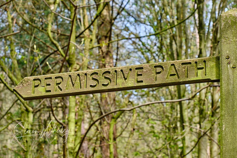
We could get technical here because it’s possible to have a permissive footpath or a permissive bridlepath. Either way, the route will generally be signed in orange.
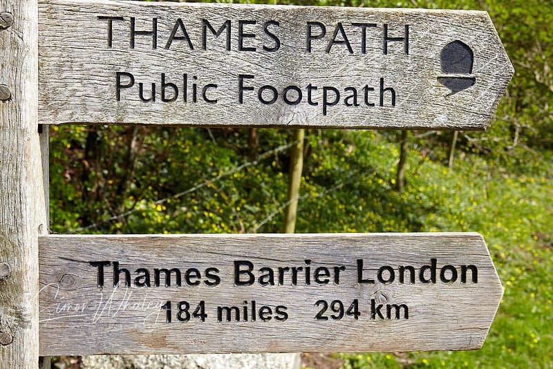
National Trails
Another sign to look out for is an acorn logo. These denote our National Trails. These are our creme-de-la-creme footpaths — long-distance routes that are heavily promoted for tourism, and (in theory) well-maintained.
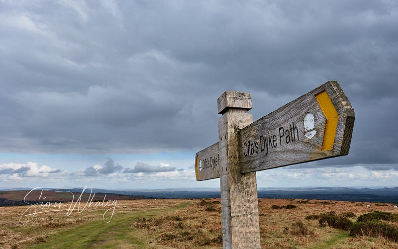
You’ll often see the acorn symbol in conjunction with another footpath sign. So in the photo above, the acorn symbol denotes that Offa’s Dyke is a National Trail, but on this section, because the arrow is painted yellow, it’s following a footpath as the legal right of way.
Sign Variations
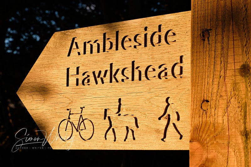
Of course, having a simple system like this (yellow for footpaths, blue for bridlepaths, and red for BOATs) is clearly far too confusing for some local authorities who don’t use the colour-coded signs and are either opting for words …
… or they’re using symbols to denote who can use the path …
And just as Erie Astin commented in her The Signs of Dublin, don’t be surprised to see some bi-lingual signs in Wales …
Scottish Paths
I mentioned at the start that this colour-coding system refers to England and Wales because Scotland has different laws when it comes to access. You will find footpaths in Scotland, and other waymarked routes (often with green and white metal signs). But for many years, Scotland has also enjoyed a right of access, where people can roam freely across mountains and moors, as long as they do so responsibly.
Open Access Land
Because the Scots have had this right to wander freely across open, uncultivated land, a similar system was introduced in England and Wales. (It’s a little more complicated, because England has a greater population and less uncultivated land, but the UK Government explains it all here.) Often called a ‘Right to Roam’, it’s not — it’s a right to access open land in a managed way.
In England and Wales, when you access Open Access land, you can step off the path, or bridlepath, and wander wherever you like, within the Open Access land boundary. (These are marks on the maps.) But, guess what? There’s a sign for this! (Actually, there are two.)
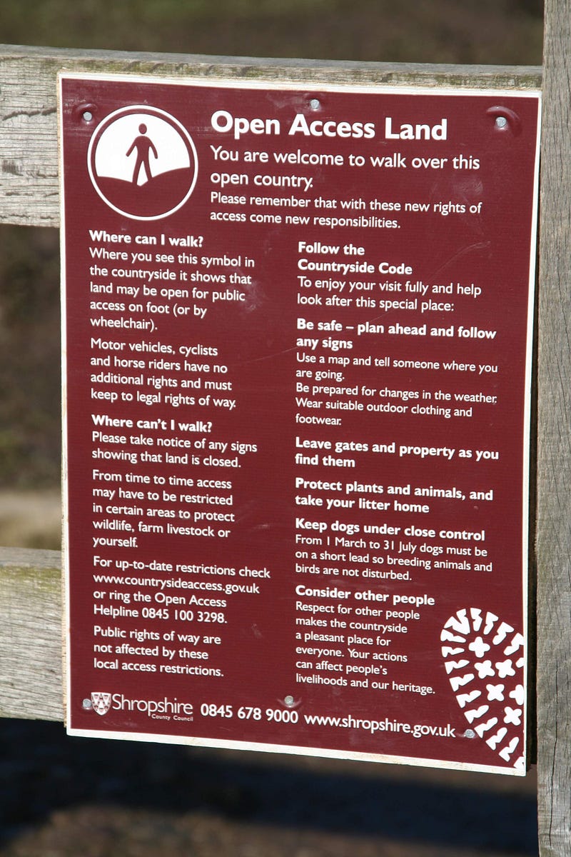
When you see a brown man walking on two brown hills, that’s the sign that you’re entering some open-access land at a designated access point. (The same logo appears, but with a red line through it when you’re leaving an open access point.)
So there you have it — the signing system for going for a walk in England and Wales. Just don’t ask me what to do when the weather obliterates all the signposts!
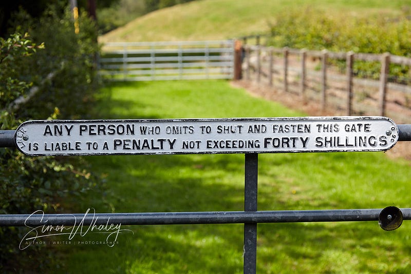
Oh yeah, and whatever you do, always follow any signs about closing gates!
Happy walking!
(And don’t forget to check out Adrienne Beaumont’s Lost in Translation and Erie Astin’s The Signs of Dublin)