
THE MEGADROUGHT SERIES 2022, PART 5
And You Thought The Colorado River Was In Trouble
Climate Change Takes Aim at the “Breadbasket of America”
Hydrologically speaking, Kansas has a split personality.
While the Eastern part of the state is green and lush, the Western part is brown and dry. It’s as if western Kansas is merging with the current drought in the Southwest. Aridification is marching east.
We’ll get back to that. But there’s a more significant cause for concern.
The Ogallala Aquifer
If Lakes Powell and Mead are ground zero of the Colorado River crisis, this underground resource claims the same title on the Great Plains.
Named by a geologist in 1898, it is one of the largest aquifers in the world, and the largest in the U.S. First discovered near Ogallala, Nebraska, it is comparatively shallow, which allowed early farmers and homesteaders access to water. However, it wasn’t used on a large scale until the 1950s, when diesel-powered pumps began to replace windmills, and center pivot irrigation was developed. (You know those green circles you see when flying over the Midlands at 39,000 feet? Center pivot.) The aquifer represents about 30% of all groundwater used for irrigation in the country.
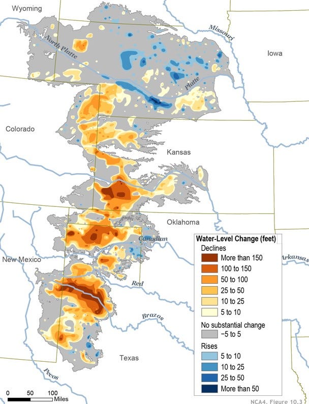
The aquifer extends from west-central Texas to South Dakota and lies underneath parts of eight states.
From 1937 to 1971, the number of wells drilled in West Texas alone grew from 1,166 to more than 66,000. This turned one of the poorest farming regions in the country into one of the wealthiest.
And as you can see from the map, the Texas portion of the aquifer is the most depleted.
In western Kansas, 80 years of pumping has also caused the water table to plummet. As a result, some wells are dwindling in their ability to extract water, while others have been emptied altogether.
“The aquifer shrank by more than a foot in 2021; one county in western Kansas only has an estimated ten years of aquifer water left” ~Progressive Farmer
“The Ogallala aquifer is being depleted at an annual volume equivalent to the flow of 18 Colorado Rivers. Nature can’t keep up with human demands.” ~Scientific American
“A report by USDA’s National Institute of Food and Agriculture projects that replenishing the Ogallala Aquifer would take 6,000 years at the current rate of usage.”
Within 50 years, the aquifer is expected to be 70% depleted. Some of it has to do with the drought. But most point fingers at farmers, as 90% of groundwater goes to agriculture. They’re searching for ways to conserve and make it last. Is it too late?
I’m not a doomsayer, but I’m just sayin’.
The Dry Line Heads East
From a meteorological standpoint, a dry line is a boundary between moist and dry air masses. The temperatures on either side of the line may be similar, but the difference is in the moisture content of the two air masses.
Dry lines are indicated in individual thunderstorms over the Great Plains, especially prevalent over Texas, Oklahoma, and Kansas. But a greater dry line extends from Manitoba in Canada to eastern Mexico, running roughly along the 100th meridian.
The area west of the dry line doesn’t have the moisture available to evaporate into the atmosphere to produce thunderstorms to the extent that they do in the East. Since 1979, the dry line has shifted about 100 miles east and is now closer to the 98th meridian.
The below map is a perfect example of the two Kansasases.
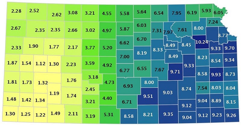
To the West of the dry line, the chief crop grown is wheat, which is less susceptible to drought, although new strains are constantly being developed to wither increasing periods of drought. Much of the Great Plains isn’t flat but rather composed of undulating hills. Center pivot irrigation only works on relatively flat land, so much of the wheat is not irrigated. The remainder of the land that is too hilly for farming is used for rangeland.
Since it is a water-intensive crop, corn is king on the East side. High-yielding corn requires 22–30” of rain per year, based on many variables. As aridification drifts east, adapting to this drying world will be more difficult for those on the “corn side.” Fields may have to be planted with wheat instead or converted to rangeland. This would result in higher prices for corn and corn products, which cows eat, resulting in higher beef prices. Extreme to exceptional drought is now indicated in southwestern Kansas.
In a rare late-spring heat wave in western Kansas, thousands of heads of cattle in feedlots died due to the stress from the heat and humidity.
Haskell County in southwestern Kansas has been the top cattle-producing county in the state. The temperature increased from 79° to over 100° for four days in two days. There was no rain and nothing to protect the cattle from the heat. There was no wind.
If climate change can produce this kind of devastating impact, think about what will happen as it gets even warmer—another threat to our food supply.
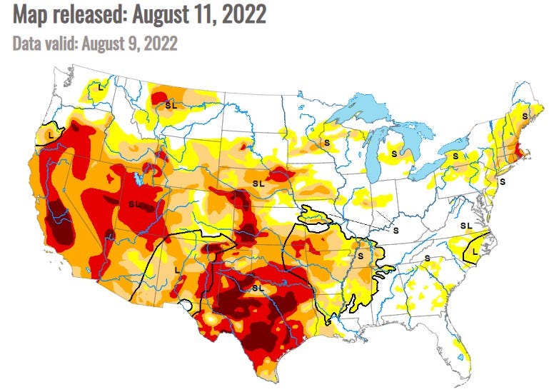
The North American monsoon season has been active, which has brought heavy rains to eastern Colorado and western Kansas. Southwestern Nebraska is also in the grips of drought, and a water war is breaking out there.
A Water War Begins On The High Plains
The High Plains of northeastern Colorado and southwestern Nebraska are in moderate to extreme drought. This is a vast area of rangeland for cattle, as well as for farming wheat and corn.
The Supreme Court signed off on a compact 99 years ago stating that Nebraska could seize land belonging to Colorado along the South Platte River to build a canal. In the meantime, Colorado has proposed to either siphon off or store more water from the South Platte well before Nebraska would dig a diversion canal. They say it is needed for the ever-growing Denver Metropolitan Area.
The compact would allow Nebraska to pump up to 3,700 gallons of water per second from mid-October to April. Nebraska has pledged $500 million it has in reserves to spend on the project. While the South Platte’s groundwater helps feed the shrinking Ogallala aquifer, this project would simply move the water down river some 24 miles.
I don’t know about those Huskers. It’s been quite a while since they’ve won any football titles. Look for this decision by the court to be an ongoing rivalry between the two states.
Conclusion
Like the megadrought in the West, we don’t know if or when the Ogallala aquifer may run dry. There are varying depths, presently at its deepest in Nebraska. Everything and everyone is thirsty. Even El Paso, Texas, could be a drain on the aquifer.
T. Boone Pickens, a billionaire Texas oilman, has proposed selling the groundwater on the land he owns in west-central Texas to El Paso. Then, a water pipeline would be built from his 24,000 acres in the Panhandle — a 654-mile span — at the cost of $2.1 billion. That’s going to be some mighty expensive water.
Amarillo, Texas, recently purchased 15,768 acres of water rights in non-adjacent Roberts County, estimated to improve the city’s water supply by 8%. The cost for the pipeline to the city and other expenses are about $1 billion. And where is the water coming from? You guessed it.
Everyone else is doing it. Care for a straw?
In Part 6 of The Megadrought Series 2022, we’ll take on Texas. If it’s still a state.
Sources:
- “The Next Disaster Coming to the Great Plains” by Lucas Bessire in The Atlantic, 12/26/2021
- “Running Out: In Search of Water on the High Plains” by Lucas Bessire
- “A Free Market Plan to Save the American West from Drought” by Abraham Lustgarten in The Atlantic, March 2016
- Amarillo Globe-News, 7/27/2022
- “The Ogallala Aquifer” in AgFacts as published in Scientific American, 10/08/2020
- “The Ogallala Aquifer: Saving a Vital U.S. Water Resource” by Jane Braxton in Scientific American, 3/1/2009
- “What is a Dry Line, and Why Does it Create Severe Weather?” by Nicolas Shelton on boldmethod.com, 7/17/2021
- “A Nation Divided: Arid/Humid Climate Boundary in U.S. Creeps Eastward” by Sharmon Hall in Scientific American, 4/27/2018
Here are Parts 4A and 4B of The Megadrought Series 2022:
Like what you’re reading? Consider subscribing to Medium. For the price of a monthly magazine ($5/month), you’ll have access to all of my stories and thousands of other writers. And I’ll get a wee bit! Just click the link below.