avatarDark Energy Articles

Free AI web copilot to create summaries, insights and extended knowledge, download it at here

2831

Abstract

width="500"> </div> </div> </figure></iframe></div></div></figure><h1 id="af46">OASIS mission to help protect land from rising sea levels</h1><p id="03a3">But drought is not the only problem. Qatar, which is funding the mission, is in extremely low-lying terrain. In some areas, it is as little as one meter above sea level. The country’s highest point rises to just 82 meters above sea level. This means that the regularly recorded rise in sea and ocean levels will have catastrophic consequences for the country.</p><blockquote id="de76"><p>“Already, islands belonging to Qatar are disappearing, causing, among other things, a shrinking of the country’s maritime territory. Other countries have a similar problem, including Poland, whose coastline is regularly shifting inland. In the USA, Florida is threatened. To be able to rescue the situation, it is necessary to determine the rate of melting of the ice cap. This is the second important part of the OASIS mission” — Artur Chmielewski explains.</p></blockquote><p id="0924">The mission’s radars are primarily to assess the underside, invisible part of the glaciers. It is the lack of precise data on ice thickness that is one of the main problems preventing correct calculation of sea and ocean level rise. It is estimated that permafrost can be as much as four kilometers thick in some places. However, according to many researchers, the underestimation of thickness can be as much as a kilometer.</p> <figure id="b895"> <div> <div> <img class="ratio" src="http://placehold.it/16x9"> <iframe class="" src="https://cdn.embedly.com/widgets/media.html?type=text%2Fhtml&amp;key=a19fcc184b9711e1b4764040d3dc5c07&amp;schema=twitter&amp;url=https%3A//twitter.com/astroengine/status/1309025168354881536&amp;image=https%3A//i.embed.ly/1/image%3Furl%3Dhttps%253A%252F%252Fabs.twimg.com%252Ferrors%252Flogo46x38.png%26key%3Da19fcc184b9711e1b4764040d3dc5c07" allowfullscreen="" frameborder="0" height="281" width="500"> </div> </div> </figure></iframe></div></div></figure><h1 id="ccb2">How was the OASIS mission designed?</h1><blockquote id="fa0e"><p>“We plan to send not one satellite into orbit, but five. It is to be one large mother ship and four smaller ones. This will allow us to make more precise measurements. The mission can be expanded to include more satellites, which would allow even more precise data to be collected. Both the Qatar Foundation and JPL are open to cooperation from other countries concerned about drinking water and rising sea levels,” says the mission manager.</p></blockquote><p id="973e">The same people who built the Mars Reconnaissance Orbiter (MRO) mission radar are responsible for the radar design. Now they are

Options

also working on the REASON radar to be part of a planned mission to Europa, a moon of Jupiter. This mission has been named Europa Clipper. It is scheduled to launch as early as October 2024, while OASIS could launch three years later, in 2027. Scientists associated with the mission have completed a feasibility study and are waiting for the green light from NASA and the Qatar Foundation to move into Phase A of the project.</p><figure id="b78c"><img src="https://cdn-images-1.readmedium.com/v2/resize:fit:800/1*DfsqmZRpDDlQSTnpqQfoSw.png"><figcaption>Sahara from space — [Photo: Przemek Pietrak, <a href="https://creativecommons.org/licenses/by/3.0">CC BY 3.0</a>, via <a href="https://commons.wikimedia.org/wiki/File:Globe_-_Sahara_from_space.png">Wikimedia Commons</a>]</figcaption></figure><h1 id="0a5c">When will the OASIS mission begin?</h1><blockquote id="e84b"><p>“Construction of the radar itself will take about three years. It will be located on the main satellite. The other vehicles, traveling on close trajectories, will be 250 to 500 meters away from the mother ship. This will allow us to obtain imaging resolution on the level of one kilometer“— says Artur Chmielewski.</p></blockquote><p id="5f5b">The satellites are expected to travel in low Earth orbit, at an altitude of about 450 kilometers. That’s about 50 kilometers higher than the International Space Station. Since there is still a residual atmosphere at this altitude, the main spacecraft will be equipped with a propulsion system that will allow it to raise its orbit as it descends due to friction.</p><p id="61e5">We can only keep our fingers crossed that this mission will repeat the success of the Mars Reconnaissance Orbiter. If the OASIS mission allows us to better understand the mechanisms behind Earth’s hydrological cycle, we will have a better chance of countering climate disaster.</p><div id="25ac" class="link-block"> <a href="https://readmedium.com/the-theory-of-relativity-or-what-einsteins-genius-was-all-about-6067704eab29"> <div> <div> <h2>The theory of relativity, or what Einstein’s genius was all about</h2> <div><h3>More than 100 years have passed since the publication of the general theory of relativity. Although its author is…</h3></div> <div><p>medium.com</p></div> </div> <div> <div style="background-image: url(https://miro.readmedium.com/v2/resize:fit:320/1*QclLzJDgb21mp4SU4ERSJA.jpeg)"></div> </div> </div> </a> </div><p id="2542"><b>Cool that you made it to the end of this article. I will be very pleased if you appreciate the effort of creating it and leave some claps here, or maybe even start following me. Thank you!</b></p></article></body>

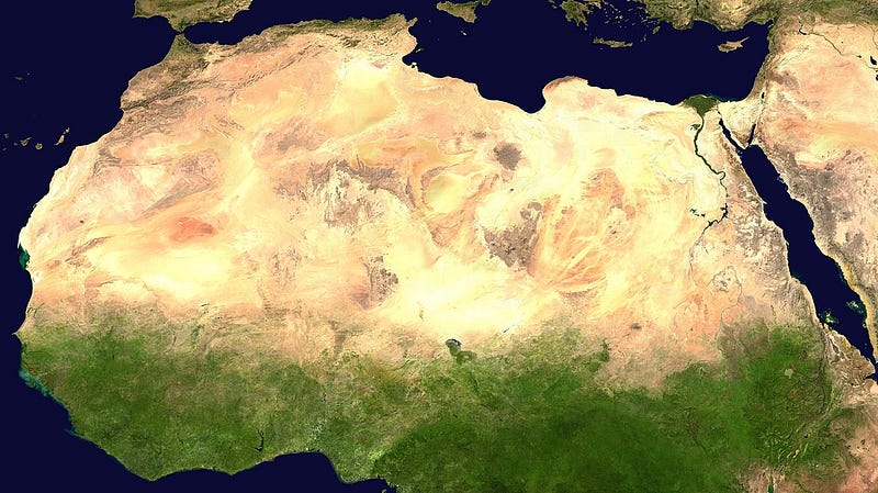
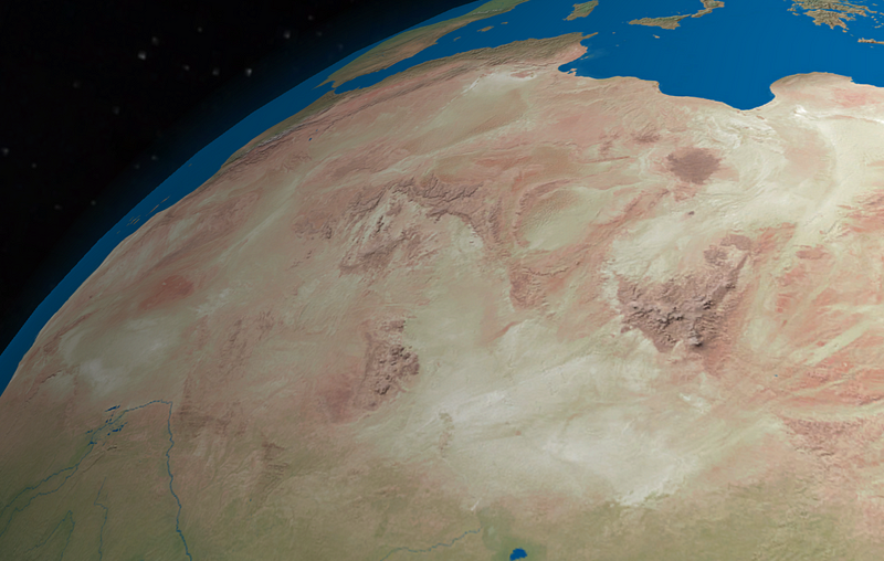
OASIS mission — A satellite constellation to look under the sands of the Sahara!

The goal — to study the aquifers of the Sahara and determine the rate at which glaciers are melting. NASA’s planned JPL “OASIS” mission uses methods proven on Mars to protect Earth.

Sahara — [Photo: NASA, Public domain, via Wikimedia Commons]

Scientists associated with the Orbiting Arid Subsurfaces and Ice Sheet Sounder (OASIS) research project are developing a novel satellite mission. The mission aims to survey the Sahara and Greenland to look for underground water sources. The technology to be used comes directly from NASA’s MARS Reconnaissance Orbiter (MRO). A second major focus is to assess the rate of glacier melt, the direct cause of rising ocean levels.

The mission is being prepared on behalf of the Qatar Foundation. The Qatar Foundation wants to protect the Arabian Peninsula from flooding and to provide drinking water for the peoples of North Africa and the Arabian Peninsula.

OASIS mission will use Mars radar to study Earth

“We want to use space technology, i.e. satellites equipped with radars similar to the one that found water under the surface of Mars. We will do this to explore drinking water resources hidden as much as 700 meters below the surface of the desert. We know there are fresh water reservoirs there. According to geologists, as recently as 700,000 years ago the climate in the Sahara was much wetter. It rained there, which seeped deep beneath the ground surface. These reservoirs feed the subterranean waters, the aquifers, which can be a lifeline for people living in drought” — explains Artur Chmielewski, OASIS mission manager on behalf of NASA’s Jet Propulsion Laboratory.

According to the latest data, the worsening drought could lead to a natural disaster and the need to displace 450 million people. This would result in a gigantic humanitarian crisis.

OASIS mission to help protect land from rising sea levels

But drought is not the only problem. Qatar, which is funding the mission, is in extremely low-lying terrain. In some areas, it is as little as one meter above sea level. The country’s highest point rises to just 82 meters above sea level. This means that the regularly recorded rise in sea and ocean levels will have catastrophic consequences for the country.

“Already, islands belonging to Qatar are disappearing, causing, among other things, a shrinking of the country’s maritime territory. Other countries have a similar problem, including Poland, whose coastline is regularly shifting inland. In the USA, Florida is threatened. To be able to rescue the situation, it is necessary to determine the rate of melting of the ice cap. This is the second important part of the OASIS mission” — Artur Chmielewski explains.

The mission’s radars are primarily to assess the underside, invisible part of the glaciers. It is the lack of precise data on ice thickness that is one of the main problems preventing correct calculation of sea and ocean level rise. It is estimated that permafrost can be as much as four kilometers thick in some places. However, according to many researchers, the underestimation of thickness can be as much as a kilometer.

How was the OASIS mission designed?

“We plan to send not one satellite into orbit, but five. It is to be one large mother ship and four smaller ones. This will allow us to make more precise measurements. The mission can be expanded to include more satellites, which would allow even more precise data to be collected. Both the Qatar Foundation and JPL are open to cooperation from other countries concerned about drinking water and rising sea levels,” says the mission manager.

The same people who built the Mars Reconnaissance Orbiter (MRO) mission radar are responsible for the radar design. Now they are also working on the REASON radar to be part of a planned mission to Europa, a moon of Jupiter. This mission has been named Europa Clipper. It is scheduled to launch as early as October 2024, while OASIS could launch three years later, in 2027. Scientists associated with the mission have completed a feasibility study and are waiting for the green light from NASA and the Qatar Foundation to move into Phase A of the project.

Sahara from space — [Photo: Przemek Pietrak, CC BY 3.0, via Wikimedia Commons]

When will the OASIS mission begin?

“Construction of the radar itself will take about three years. It will be located on the main satellite. The other vehicles, traveling on close trajectories, will be 250 to 500 meters away from the mother ship. This will allow us to obtain imaging resolution on the level of one kilometer“— says Artur Chmielewski.

The satellites are expected to travel in low Earth orbit, at an altitude of about 450 kilometers. That’s about 50 kilometers higher than the International Space Station. Since there is still a residual atmosphere at this altitude, the main spacecraft will be equipped with a propulsion system that will allow it to raise its orbit as it descends due to friction.

We can only keep our fingers crossed that this mission will repeat the success of the Mars Reconnaissance Orbiter. If the OASIS mission allows us to better understand the mechanisms behind Earth’s hydrological cycle, we will have a better chance of countering climate disaster.

Cool that you made it to the end of this article. I will be very pleased if you appreciate the effort of creating it and leave some claps here, or maybe even start following me. Thank you!

Space
Climate Change
Technology
Science
Nature
Recommended from ReadMedium