
Science
Zealandia Discovered and Seven Continents Becomes Eight
Beneath the sea off Eastern Australia, an intriguing discovery is resetting our thinking about the Earth’s continental history
Recent research has proven the existence of an eighth continent off the east coast of Australia. For several years earth scientists had postulated its existence and now, finally, it has been physically discovered. It has been called Zealandia
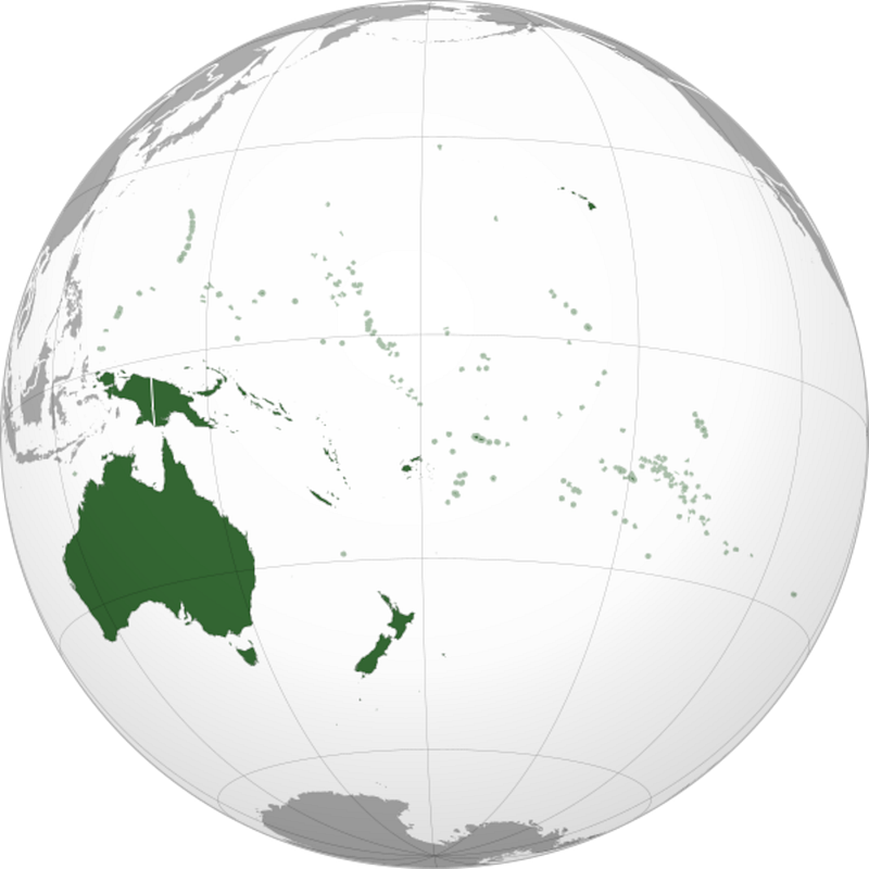
It’s like something out of Jules Verne, a new continent. But most of it is under the sea, and at the very top is New Zealand. It’s in an area generally called Oceania. This is what Wikipedia says about the region today:
Outside of the English-speaking world, Oceania is generally considered a continent, while Australia is regarded as an island or a continental landmass contained inside of the larger continent of Oceania.
The English-speaking world regards Australia as a continent.
This will have to be re-written.
Let’s take a look at the news about the discovery and some of my experiences in the area.
Background
During the Covid crisis I spent 2 years locked down in New Zealand on my boat, but I’m now back in Australia again after a trip of several months to Indonesia and New Guinea. I prefer Australia to New Zealand because of its vast vistas; I feel that it’s more ‘edgy’ than New Zealand.
The geology of Australia is very old relative to New Zealand which is still emerging violently from the ocean. New Zealand experiences on average 14,000 earth tremors every year, and the peak year recorded 34,000 tremors. When on the boat we experienced a couple of Tsunami warnings and a nearby harbour (Tutukaka) was trashed during one episode. We felt nothing.
One thousand miles apart, Australia and New Zealand are very different landmasses, separated by the Tasman Sea. I’ve sailed across the Tasman twice in my boat, and both occasions have delivered hair-raising experiences with three gales, one storm and the loss of a couple of sails (‘blown out’).
The flora and fauna of the countries are substantially different. There are no animals or insects dangerous to humans in New Zealand, while Australia has its crocodiles, dangerous snakes and poisonous spiders.
Although Australia has huge open deserts and plains it also has mountain ranges, even snow, New Zealand is much smaller, much more rugged and feels claustrophobic to me. Needless to say, my wife prefers New Zealand.
The indigenous people are also quite different. The Maoris have a warrior history, much more so than Australia’s Aborigines.
Plate tectonics
It’s many years since I studied geophysics as part of my undergraduate degree and at that time plate tectonics was a new and exciting concept, still thought to be nonsense by many Earth scientists of the time.
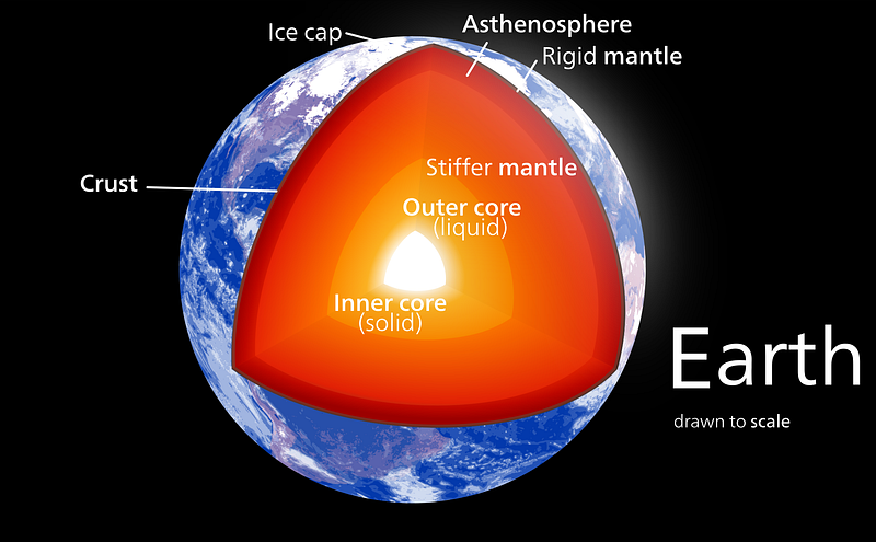
Now it’s a well established and proven theory. The continents are just ‘land’ on crustal plates ‘floating’ on the earth’s mantle and moving slowly under the complex influence of several forces including mantle convection, plate drag and mid ocean ridge push.
The plate movement of a few centimetres per year causes some plates to move under others (subduction) and where plates move apart hot material rises from the earth’s core with volcanoes being the most visible outpouring.
Earthquakes generally occur in areas of subduction (e.g. Japan) and of plate shear (e.g. the San Andreas fault which runs through California).
Continental crust thickness is usually around 40km — significantly thicker than oceanic crust, which is around 10km thick.
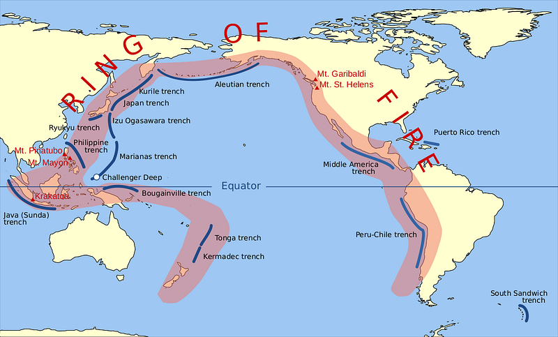
Back in ‘Oceania’, New Zealand sits on the ‘Pacific Ring of Fire’:
Earthquakes occur frequently in New Zealand as the country is situated in the collision zone between the Indo-Australian and Pacific tectonic plates, part of the Pacific Basin Ring of Fire, where many earthquakes and volcanoes occur. Most events occur along the main ranges running from Fiordland in the southwest to East Cape in the northeast. (Wikipedia)
The discovery of Zealandia
The first real clues of Zealandia’s existence were gathered by the Scottish naturalist Sir James Hector, who attended a voyage to survey a series of islands off the southern coast of New Zealand in 1895. After studying their geology, he concluded that New Zealand is “the remnant of a mountain-chain that formed the crest of a great continental area that stretched far to the south and east, and which is now submerged…”. (BBC)
In 2017, a group of geologists announced their discovery of Zealandia — Te Riu-a-Māui — in the Māori language. A continent of 1.89 million sq miles (4.9 million sq km), it is around 60% of the size of Australia.
How they found it, physically
Researchers used bathymetry — mapping the depth of water — to analyse the region. The ocean above what we now call Zealandia is significantly shallower than that surrounding it, as you can see in the image below., although some parts are very deep.
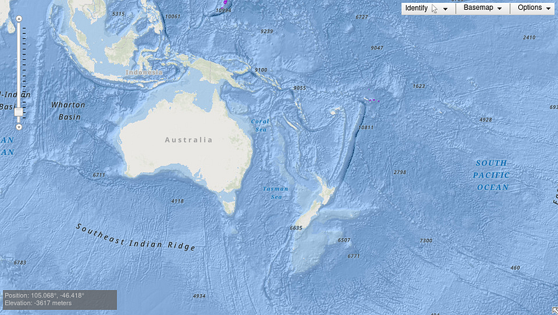
The bathymetry suggested that the area was not atop an oceanic tectonic plate (as are most of the world’s oceans). This was unusual.
By deep dredging for rock samples over a large area in the Tasman and Coral Seas, they were able to classify the dredge samples and prove that the rocks, stones and pebbles were distinct from Australian geology. Classification was done using a variety of techniques including physical rock typing, chemical analysis and paleomagnetism (magnetic field locked in to rock and lava samples).
Also, satellite data of gravity was used. These satellites detect very small variations in gravity and that data provided additional mapping input.
All this data ultimately led to the first map of the ‘new’ continent.
Mapping North Zealandia in 2022 was the final part of the research and completed the picture. South Zealandia had been mapped some years earlier.
It was a challenging survey, because some parts of Zealandia’ shelf lie at depths of more than 2,000 metres.
Formation
It is believed that about 420 million years ago, there was a huge landmass which we now call Gondwana.
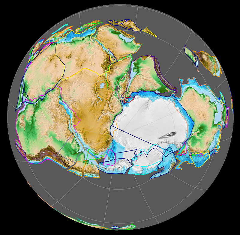
The survey results suggest that there were two stages to the formation of the eighth continent. The first began around 89–100 million years ago, leading to a split which is now the Tasman Sea between Australia and New Zealand. The second stage started soon after and led to Zealandia breaking from West Antarctica and creating the Pacific Ocean.
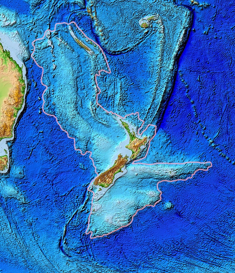
This is the latest map of Zealandia:
Why is it important?
The research is important because of its economic implications.
New Zealand has signed a United Nations treaty called the Convention on the Law of the Sea (UNCLOS). This was part of an effort to extend the country’s control over natural resources.
Typically, a country has control over an Exclusive Economic Zone which extends 200 miles from its shores. But, importantly, UNCLOS now defines five maritime zones — one of which hinges on a “continental” definition.
The recognition of Zealandia would give New Zealand control over a vast swathe of continental shelf and its natural resources.
The future
No doubt there will be extensive legal arguments about this because the shelf of Zealandia is much deeper than most continental shelves.
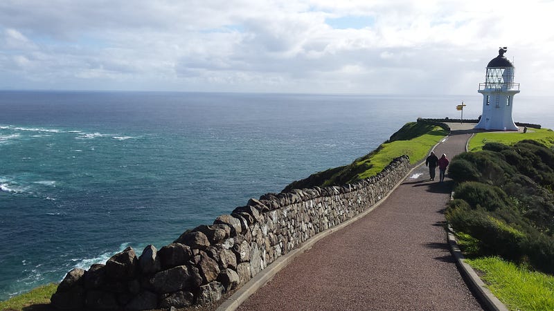
For me, another crossing of the Tasman Sea is a prospect for 2024, once the southern hemisphere cyclone season has ended. Next time I’ll definitely have a better understanding of what is beneath me, particularly as I round Cape Reinga where the tides of the Tasman meet those of the Pacific. I’ll stay well offshore!
And yes, a few reference works and school curricula will have to be changed to include the eighth continent.
References and further reading:
Source paper: https://agupubs.onlinelibrary.wiley.com/doi/epdf/10.1029/2023TC007961
Follow me and I guarantee variety in your inbox with some unusual perspectives! I write on a wide range of topics that interest me including humour, tech, space, geopolitics and travel, together with daily news events and the minutiae of my daily life living on a boat. I also write about…
…the earth beneath us

My novels are available at my Gumroad bookstore. Also at Amazon and Apple
Or maybe just buy me a coffee? and tell me what you liked reading (or not)…