Wander Wall
Hadrian’s Wall: Why the World Heritage Site is so much more than a pile of old Roman stones.
As walls go, Hadrian knew his stuff. Well, I’m sure as Emperor he didn’t build it himself, he’s bound to have delegated the job to a few thousand Romans. But I’d be very much surprised if anything we build today will still stand in over 1900 years' time.
Emperor Hadrian built his wall across the northern part of England from 122 AD. It stretched from Bowness of Solway in the west for 73 miles to Wallsend (heavens knows who thought up that name for a place!) on the River Tyne near Newcastle on the east coast. It’s the narrowest point between the east and west coasts of England. Hadrian was clearly a sensible chap.
It’s thought the wall was built to protect the northern edge of the Roman Empire from those pesky barbarians in the north (essentially, the Scots — although on the east coast, England stretches much further north, but over the centuries that bit of land has switched back and forth a bit anyway, after several disagreements).
The wall was designated a World Heritage Site in 1987 and is a popular tourist destination. It’s also one of the UK’s National Trails — a long-distance footpath tracing the line of the wall, if not on top of the actual wall in places.
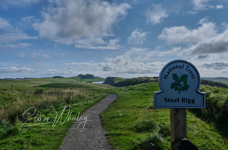
If you don’t have time to do the entire 73 miles, then a morning or afternoon tackling the three-mile section between Steel Rigg and Housesteads will give you an impressive overview of this engineering feat.
It will also give you the utmost respect for the Roman soldiers who had to trek between the various mileposts and forts (It certainly has for me.). For while there are some flat bits near the coast, the bit between Steel Rigg and Housesteads has more up and downs than a rollercoaster.
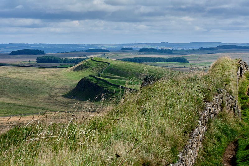
This section also reveals how cunning Hadrian was, for not only did he make use of England’s narrowest point, he also made the most of the geology here.
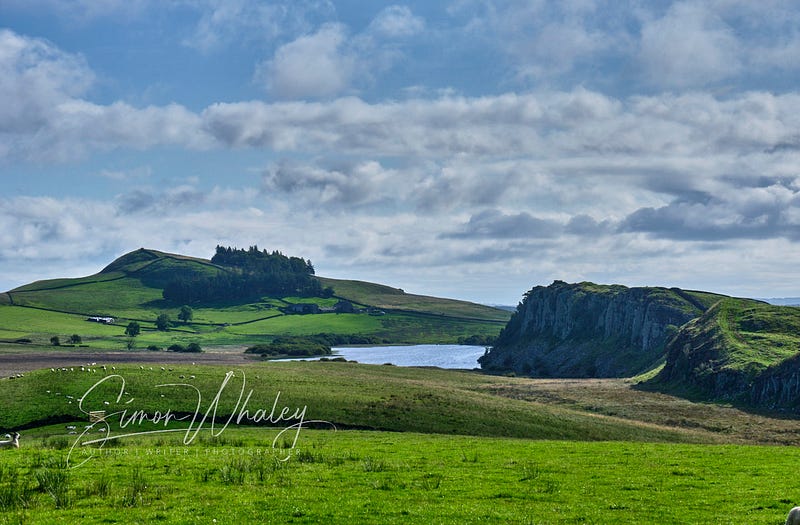
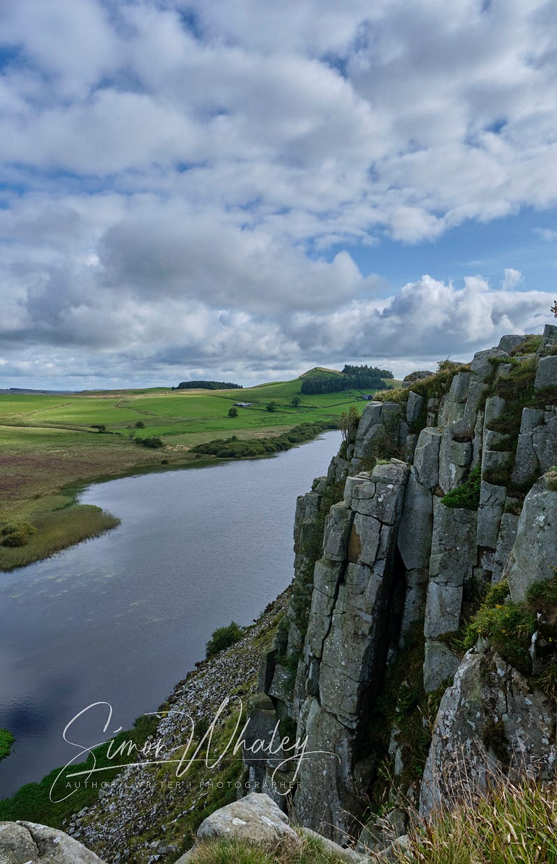
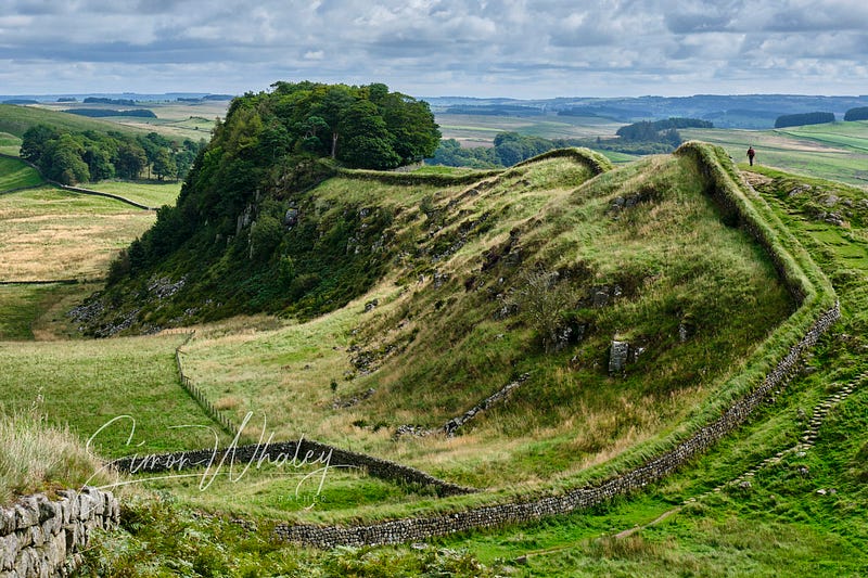
Ladies and gentlemen, I give you: the Whin Sill.
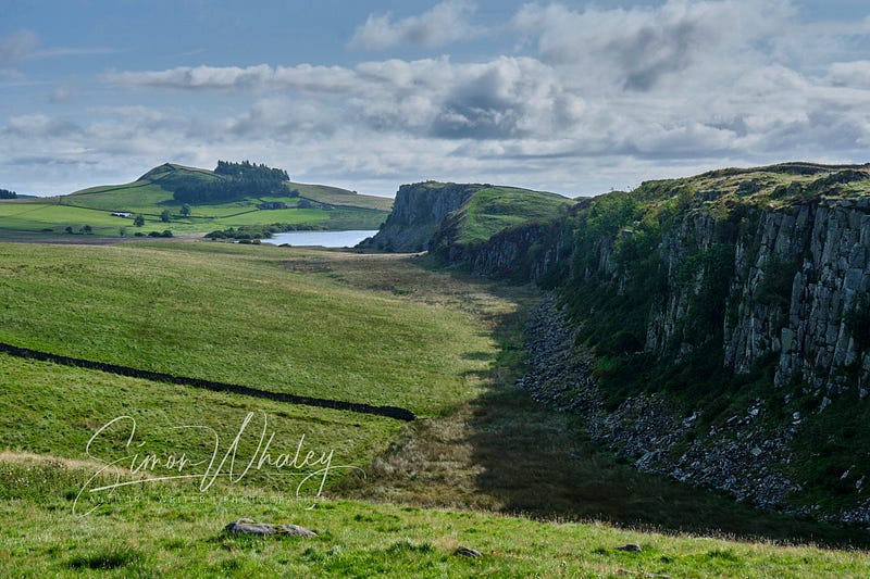
This is a ridge of dolerite rock that stretches across the neck here, thrust up millions of years ago during some shifts in the tectonic plates. Some sections are more visible than others, but for this section, the contrast couldn’t be greater.
From Steel Rigg, there’s a view that looks right along the sharp drop the Whin Sill created here: Peel Crags, Highshield Crags, and Hotbank Crags.
And perched on top, Hadrian’s Wall edges the ridge like a line of icing on top of a cake. In some ways, Hadrian didn’t need to bother with a wall at this point. Nobody in their right mind would think of attacking by shinning up these crags! Still, you might as well use the geological structure to your advantage.
From Steel Rigg, it’s a sharp drop into a valley, before climbing back up the other side. Just imagine doing this in a Roman soldier’s uniform.
The section above Peel Crags is pleasant, especially on a glorious weather day. It’s relatively flat, and the views extend southwards across England’s Northern Pennine range of mountains.
Then there’s another sharp drop and a steep incline up to Milecastle 39.
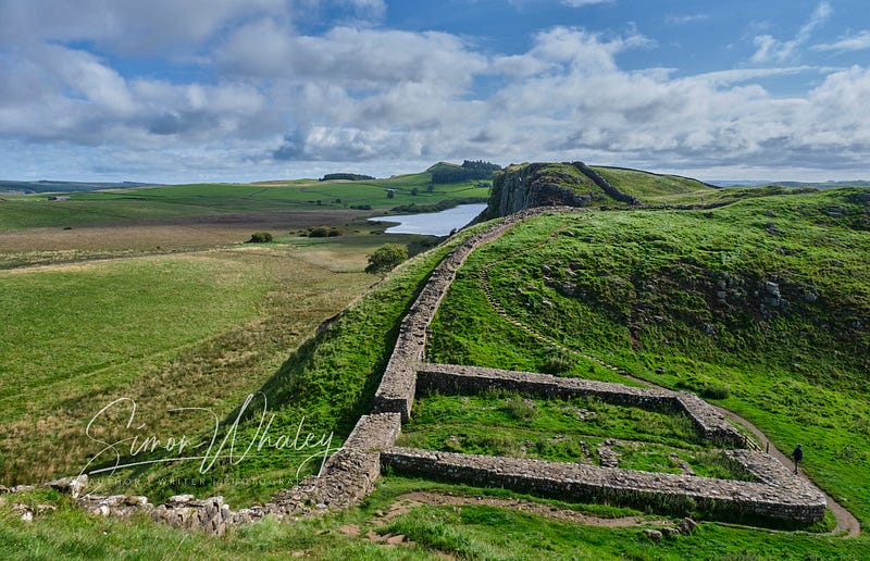
Milecastles are exactly what they say on the tin — a castle every mile. Castle, though, isn’t a great choice of word. These were more like forts, or fortlets. They were only 15 metres by 18 metres, generally, and many of them guarded an official gateway through the wall, as well as providing accommodation for between 20 and 30 soldiers.
As I explore Milecastle 39, it strikes me as being quite a ‘cosy’ place for that many soldiers.
Dropping down from this Milecastle brings me to one of the most photographed spots on Hadrian’s Wall: Sycamore Gap. As names go, it’s a bit like Wallsend.
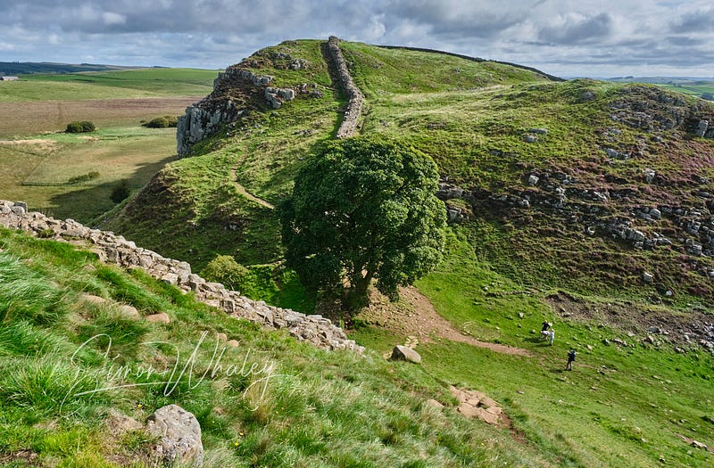
A single Sycamore Tree sits in the valley between two hills, and everything about it just looks right, from its proportions to its slightly off-centre location to the fact that it was the Romans who introduced sycamore trees to Britain.
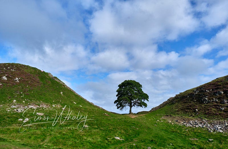
I stay here a while, not just because of the great photo opportunities, but because everyone else is trying to get a photo, no doubt for their Instagram feed.
Update (28th September 2023): Sadly, only a month after I wrote this article, some ‘vandal’ cut down this tree. It’s not an exaggeration to say that much of the UK is devastated by this news — check out the hashtag #SycamoreGap on X. I am truly privileged to have had the opportunity to see this tree and am so sad that others will not get to see it.
Still, it’s not long until I’m huffing and puffing my way up the side of Highsheild Crags. The good news is, once I’m at the top, the path is relatively level for a while, giving me an opportunity to admire the views south over the North Pennines again.
However, I have to be careful, because the path gets close to the edge of the crags, and it’s a 200-foot drop to Crag Lough below!
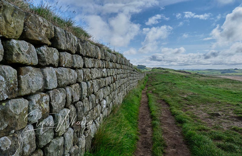
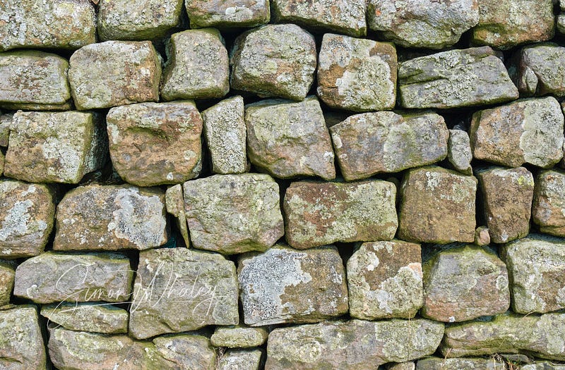
As I drop down to Milecastle 38, it’s a long, steady climb up to Hotbank Crags, and I pause to admire the wall in all its glory. Considering it’s been here for over 1,900 years, and it’s exposed to some pretty inclement weather here, it’s in pretty good shape. All the lichen on the stones is a good indication of the clean air round here.
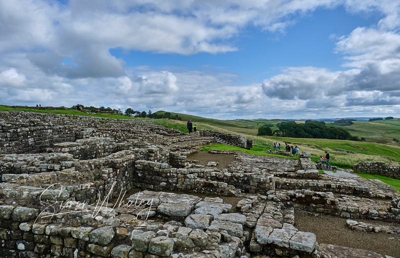
There’s another switchback of ups and downs, as the wall continues its eastwards journey, and soon after reaching Milecastle 37, I reach the Roman Fortress of Vercovicivm (fort of the effective fighters), or Housesteads, as it is known today.
Managed by both the National Trust and English Heritage (which means members of both organisations can get in for free), Housesteads is the most complete Roman Fort in Britain.
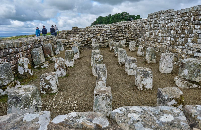
Some 800 soldiers lived here in barracks, and they also had access to a hospital, granaries, and communal toilets. (The National Trust/English Heritage gift shop came later!)
There were sixteen of these forts dotted along the wall, of which this is best preserved. It is also unusual in that it is one of the few Roman forts in Britain that did not have a running water supply. The soldiers here were reliant on rainwater. (Knowing what the weather can be like around here, I don’t think they ever had a water supply issue!)
From here, I turn around and head back. There’s a gentler, more sedate path that runs about a hundred metres parallel to the wall, which I opt for. Being a grassier track means I can enjoy the far-reaching views more and not have to worry about tripping over a rock somewhere.
Those Roman soldiers certainly had some amazing scenery to look at, when they weren’t watching for Barbarians coming from the north. But I bet in the depths of winter, they wished they were stationed somewhere much further south . . . like the Mediterranean.
This section from Steel Rigg to Housesteads and back gives a great overview of Hadrian’s Wall. And there’s much more parking (and a bus stop) at The Sill, the National Park Visitor Centre, just 600 metres from Steel Rigg, which gives further information about the wall and the Whin Sill, as well as serving a decent cup of tea and a slice of cake!
Oh yes, and the gift shop is jam-packed with items you never knew you needed, especially ones with a sycamore tree on them!