
Mature Flâneur Down Under
Tim Versus Mount Doom (in New Zealand)
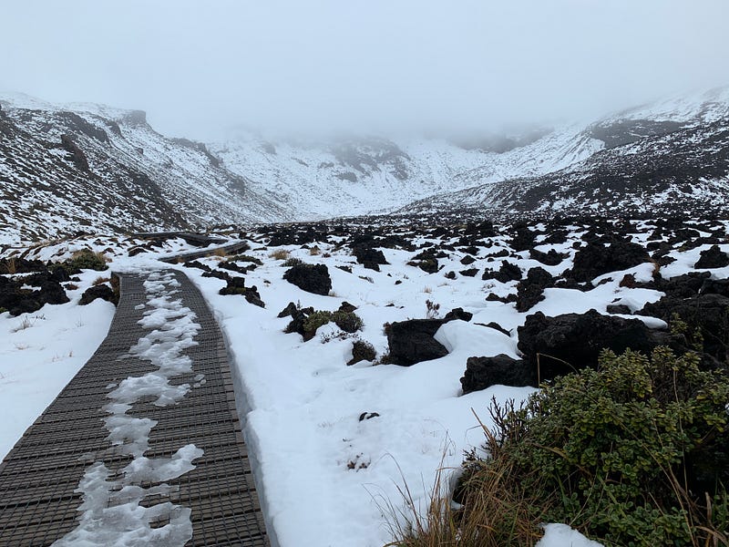
The Tongariro Alpine Pass in wintertime
(This is my entry into Globetrotter’s monthly challenge. The July theme is Action)
Teresa (my beloved spouse) and I stayed on the shores of Lake Taupō, New Zealand, for three blustery days in early July. Taupō is the largest lake in New Zealand, formed from the caldera of an impossibly vast volcanic eruption about 1,800 years ago. It blew 19 cubic kilometers of matter into the sky. That would be the equivalent of 7,600 Great Pyramids of Giza shot into the atmosphere. It was the greatest eruption the earth had experienced in over 5,000 years.
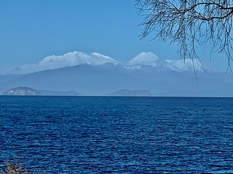
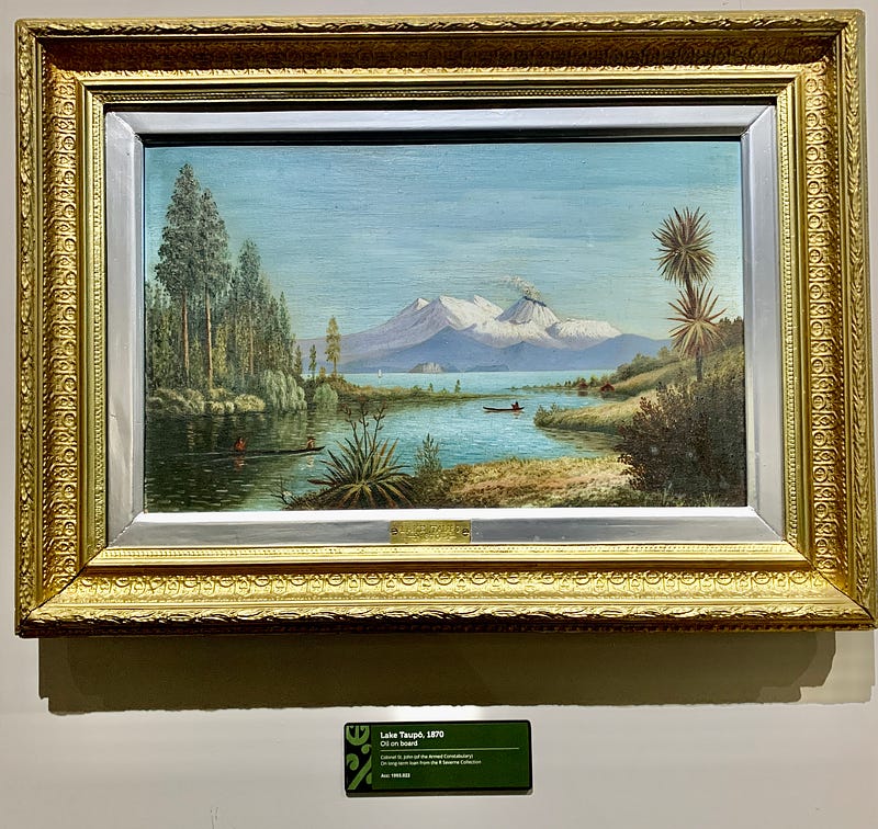
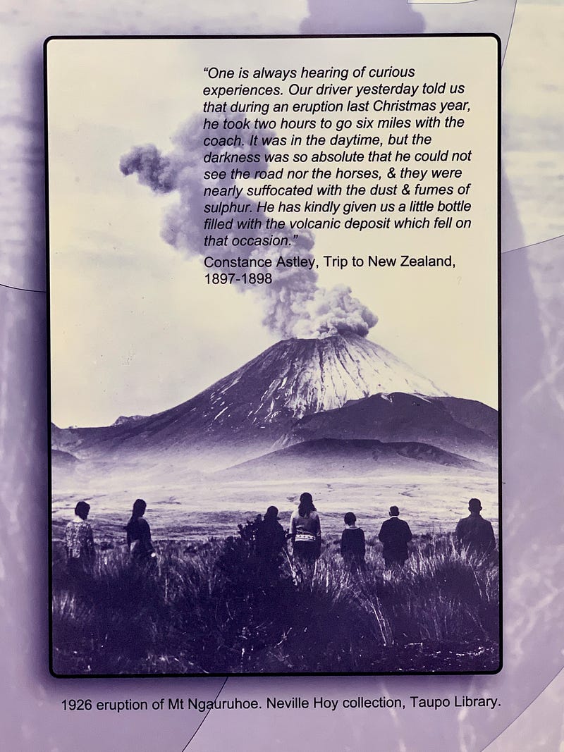
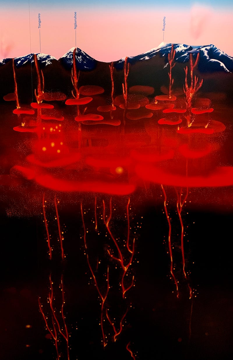
From the bay window of our rental condo facing the lake, we could see a further range of volcanoes rising up from the far shore of the caldera, some sixty miles away. These lesser cones are covered in snow in the southern winter months (July is like January in NZ). Cold and impressive, these giants are far from extinct. A painting in the Taupō museum shows one of them, Ngarurhoe, still smoking in 1870 (it’s the large, perfect cone just right of center in the photo above). There’s also a museum photo of Ngarurhoe erupting in 1926. In fact, Ngarurhoe is the most active volcano New Zealand, with 45 eruption events recorded in the 20th century.
The mountain’s Māori name means “Throwing Hot Stones.” Ngarurhoe plays a central role in the defining Māori myth of the area. The ancestor-chief who first reached the shores of Lake Taupō found the place deadly cold. So he summoned volcanic fire from Hawaiki, the mythic homeland, which emerged at Ngauruhoe.
Surprisingly, Ngauruhoe also played a role in an important Western cultural myth: it was the stand-in for scenes of Mount Doom in the Lord of the Rings Trilogy, which was filmed in New Zealand:
While the Hobbits were able to climb Mount Doom and destroy the accursed ring in its molten crater, alas, in real life, one is not allowed to do so. Due to the mountain’s sacred nature for the Māori, walking on Ngauruhoe is forbidden (sorry Frodo!). Instead, there is a hike that threads a path up a valley next to Ngauruhoe, across the saddle to nearby Mt Tongariro, and then descends on the other side. The hike is 19 km long, takes about 8 hours, and is reputed to be the best one-day hike in New Zealand.
In the winter time the local tourist bureau actively discourages people from doing the Tongariro Crossing without special training, full mountaineering gear, and a guide. At age 64, I’m a bit too old for all that. But, as this is the only time I was ever going to be in New Zealand, I thought I might as well walk the first part of the trail, up the valley to the flank of Mt. Ngauruhoe.
I dressed warmly, took all my rain gear, and headed out for the day. Ninety minutes later, I arrived at the trailhead at the end of a gravel road. The large parking lot was totally empty except for one other car. There were several empty bus bays, and I could tell that during the summer months this route must be packed with hikers. But not today. A big sign warned — and I paraphrase it here:
Do not do this hike in winter! Unless:
- You are a trained and experienced in winter mountain climbing
- You are trained in avalanche awareness
- You have an emergency geolocator beacon in case you get buried by an avalanche
- You have a death wish
Okay, I made up the last bullet, but that was the tone of the sign. I checked zero of these boxes, but I was not too worried because I only intended to walk part way, and if the trail was clear of snow, maybe climb to the saddle before heading back down. I even packed my new hiking poles, just to be on the safe side. The weather was overcast when I started, but not raining. I put on my rain pants and jacket to be on the safe side and headed up the valley.
This moment is always one of the sweetest: starting along an unknown path on an empty track through the wilderness. The vegetation was scrubby and tough, much of it russet-red in the dead of winter. There was a wind at my back, which made walking all the easier. No more than a few hundred meters along the trail, I passed two guys walking the other way (they were too tall to be Hobbits). That was obviously their car in the parking lot. It was 1 pm and they were finished for the day, while I was just starting out. The sun would set at five. With a bit of a qualm, I realized I would be truly alone on the mountain for the rest of the afternoon. Then it began to rain.
As the trail rose white daubs of snow appeared on the sides of the valley. Then streaks and patches. After about an hour, the landscape looked like a Dalmatian. Fortunately, the track here was on a raised wooden walkway, covered with a steel grid, easy to grip with my boots. But, the weather was getting worse. Rain picked up, and visibility deteriorated. I could still see enough of the walls of the valley to be confident there was no accumulation of snow, so no chance of an avalanche. But then I hit this signpost:
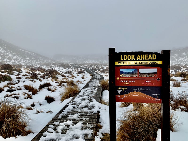
Notice that this is for summer weather, and it advises “TURN BACK!” if the weather is cloudy — let alone rainy, windy and foggy. But, again, I was not going to the top, just out for an afternoon stroll. So, onward.
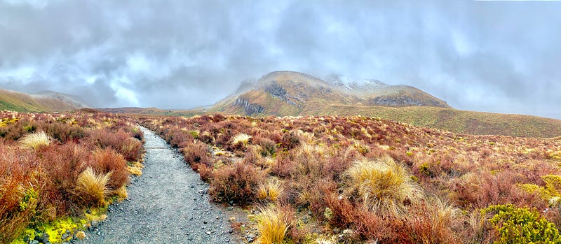
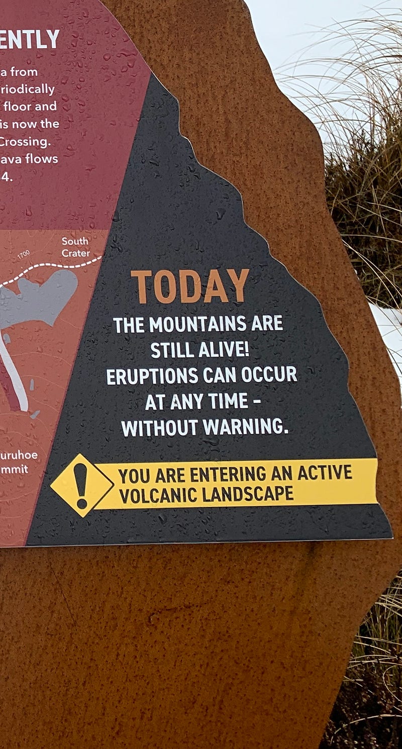
The trail kept rising, the valley narrowing. Wooden steps climbed to a higher valley that was icy cold, and purely breathtaking. Big black lumps of misshapen rock cluttered the land. A sign next to the trail explained that during the more recent eruptions of Mt. Ngarurhoe, lava flowed down this valley floor. I imagined what this day might have looked like back then — fire and ice, steam rising hot as the cold rain fell. Looking up, across the valley floor to where fresh snow covered the rising slope, I knew I had reached the base of Mount Doom. I was at the foot of Ngauruhoe, but I could not see it.
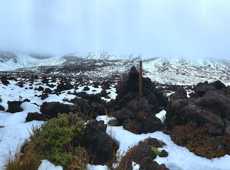
As the sign alarmingly explained: “The mountains are still alive! Eruptions can occur at any time—without warning.”
The rain was really coming on strong by this time, and the wind at my back was howling. The walls of the valley form a wind funnel here, so I had read, that gathers force and velocity to well over 60 miles per hour. Fortunately, I had brought my new, most favored hiking companion: a sturdy folding umbrella. I deployed it now to keep my head and torso relatively dry, holding it open at my back, I could feel the wind push me forward up the trail.
I thought, why not make it to the end of the valley, where the trail climbs the slope towards the saddle? It was a bit slippy-slidey on the icy part of the walkway. Not a big deal, so long as I don’t fall off and twist an ankle. All alone, well out of cell service, there would be no one coming to my rescue today. I corrected that thought: rather than picturing myself twisting an ankle, better to visualize placing each step firmly and surely, staying aware and taking my time with each step.
I followed the walkway in the photo above to where it ended in a marshy bowl. A mucky trail followed the stream for awhile. it ended in tracks through the snowfield leading up to where the climb to the saddle begins. Oh, I sorely wanted to go there. But the snow ahead was knee deep, and soon I would be post-holing through it, and possibly breaking through into marshy water. Ahead, the steep sides of the valley were accumulating snow now, enough that an avalanche might be possible. It was time to call it quits.
I thought of Sam. I thought of Frodo. They did not turn back. They pushed on! But, they had a mission. They had a world to save. I was just a flâneur out for a ramble alone where perhaps he should not be. Plus — it was not raining when the Hobbits climbed Mount Doom.
Umbrella toward the wind, the walk back was like tacking a sailboat into a gale. I had to lean into it. I couldn’t hold the umbrella normally for long, as it put alot of strain on one arm. So I propped the handle against my chest like a mast and pointed the umbrella horizontally into oncoming rain. Whenever the angle slipped just a little bit, the whole thing would whirl around and plop inside out.
The tops of my boots were wet now from rain running down my legs. My feet were soaked. My rain pants were no longer waterproof. They were drenched and started to sag with the extra weight. Every hundred steps or so I would have to hitch them up so they would not slip down to my knees, like some old man who had forgotten his belt. I was pretty sure I looked ridiculous on this long slow, soggy walk back from the volcano. Mr. Mature Flâneur, mythic action adventure figure: not cautious enough to stay home; not foolish enough to climb into danger; but just barely wise enough to know when to turn around.
***
Here are two great action stories from Globetrotters that have inspired me:
Oscar Rhea’s adventure last fall, climbing Kilimanjaro. I love his self-effacing humanity:
And Adrienne Beaumont’s very recent adventure, “walking the plank.” She embodies of discretion in adventure choices I probably need to cultivate, sometime in the future…
If you want to ready more of my recent stories on New Zealand, you will find them in this convenient Medium.com listicle:
And, finally, if you haven’t heard, my new book on slow travel, Mature Flâneur is now ready for pre-order: