
The trek over the track less traveled
Calling it a road trip would not be entirely accurate
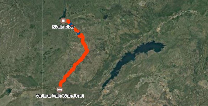
The plan: As we left Livingstone early in the morning, we intended driving in the direction of Lusaka, turning away from the main road at Kalomo and then following the “D714 graded road” to the Dundumwezi gate near the southeastern tip of the massive Kafue National Park. From there we would drive inside the park towards the campsite at Hippo Bay, on the shore of Lake Itezhi-Tezhi. This was to be the first day of our return trip from the Victoria Falls to Lusaka, in Zambia.
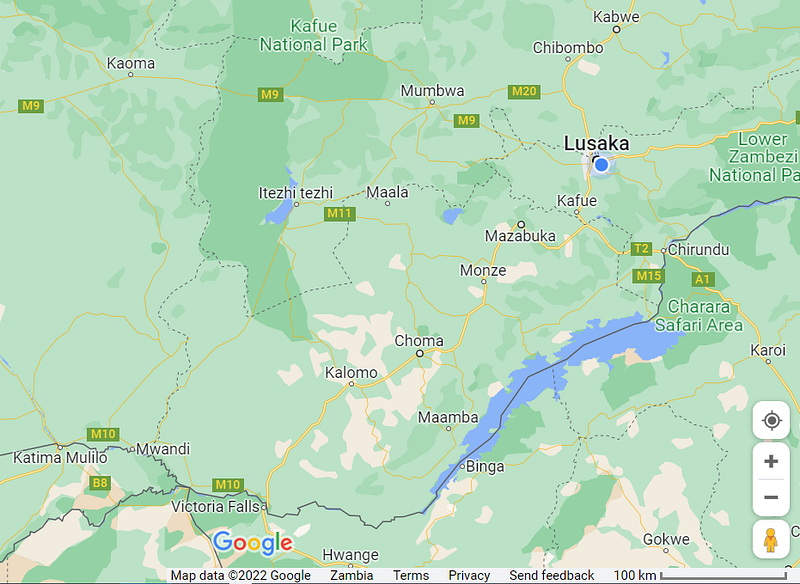
The reality: In Kalomo we turned onto a wide dirt road that was being graded (the D714?), but we somehow managed to select a wrong turning somewhere. We continued much too far in a northerly direction and had clearly missed the road to the Dundumwezi gate. In the absence of a decent paper map, or roads that could be on it, we were using Google Maps on our phones and this indicated a couple of route options northwards, towards Namwala. From there we could turn West and enter the Park near Itezhi-Tezhi.
This should also work, we thought.
Now you might also know that feeling when you are not entirely sure that you’re driving in the right direction, or on the right road, but you don’t want to turn back because it will turn out that you’d actually been on the right track and then you have to turn around again. No? Happens to me all the time.
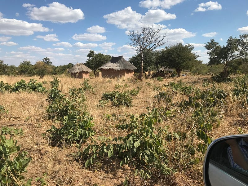
Also on this day. So we continued on roads that were getting smaller and worse as the day wore on, through little villages and dusty hamlets, between dry corn fields and fallow lands, all the time in a more or less northwesterly direction. Whenever we found intersections with other dirt roads, we would consult our Google maps, have a mini-conference, select the road to take, and soldier on.
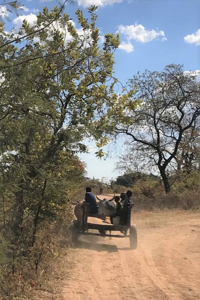
Traffic was light. Sometimes a person on a bicycle, at one point in time a broken-down pickup truck in the middle of the road, and later a few carts pulled by donkeys or oxen. From time to time, a pedestrian making his way from somewhere to nowhere. I can see you thinking: What about road signs? Uhhh.. no.
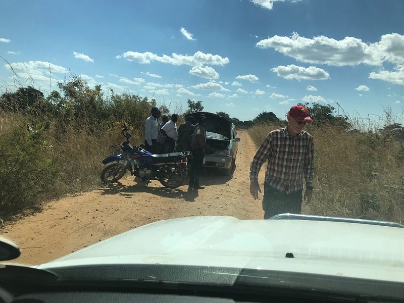
What about asking someone for directions? Yes, that we did do, we did have a female in the car.
The responses were always polite and seemed to indicate that yes, we were indeed driving in the direction of the Kafue National Park. At times we received more detailed instructions, like “soon you will come to a village and then drive past the church, then you will pass a school and then take the next right turn near the clinic”, etc. If you’ve ever driven through the African bush then you will know that these instructions are not quite as clear or as useful as you might expect: “Soon” could mean anything, “right” could actually mean the opposite and a school or clinic is not always such an obvious building.
The morning had already turned into early afternoon and by now we were sure that we had not taken the best route to Itezhi-Tezhi. However, being optimists, and being guided by the thick blue lines on Google Maps, we continued northwestwards, convinced that we would at some point reach an East-West road and then we would turn left, towards the Kafue National Park.
Now here I should explain a few things about Google Maps: If you select a starting point and an endpoint for a trip, it will pick the route that it thinks is best. It doesn’t always know that for sure, and it doesn’t help if you stray off the main roads into the African bush. Anyway, undeterred, it will still imagine some route (note: “route”, not “road”), mark it with a fat blue line on your map and send you on your merry way. Google Maps uses a GPS to plot your location on the Earth, but needs a telephone signal to access a map where this location can be plotted.
Unsurprisingly, this doesn’t really work in areas where cellphone reception is bad (or absent). Also, even if the signals are strong enough, and you are placed accurately on the map, sometimes there are no nearby landmarks on the same map. Knowing that you are exactly at the only spot on an otherwise empty map, is not very useful.
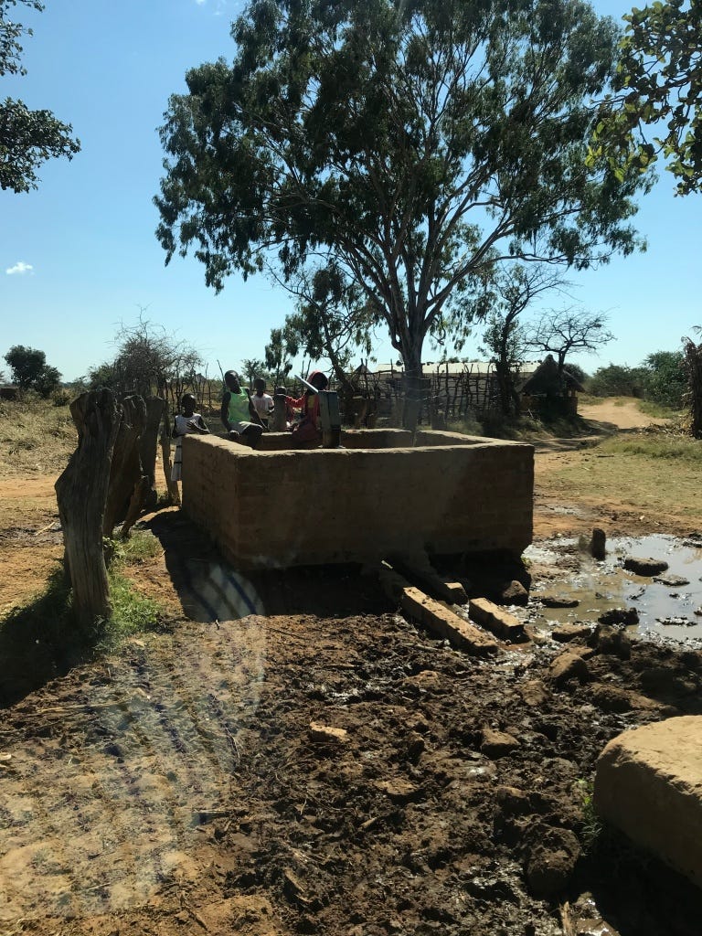
Anyway, our blue line guided us ever northwards and westwards on roads that became narrower and finally became sandy tracks. The number of villages decreased, as did the quality of English spoken there. We often greeted villagers or cyclists or pedestrians, who always responded with “Good afternoon, how are you?” and when we asked for directions they would respond with “Good afternoon, how are you?” Friendly, but not useful.
By mid-afternoon, we’d had to backtrack a few times after tracks disappeared or turned into narrow, dry riverbeds, and we’d already accepted the fact that we would not reach the Hippo Bay campsite before dark. During my years of living and working in Africa, I have always advised against driving at night, you never know whether a road might be blocked with something, or whether there’s a serious pot-hole or a truck without lights coming towards you. None of these dangers seemed real on this trek, so we continued on.
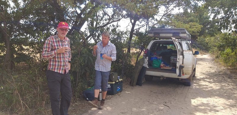
Yes, we were getting a bit worried, but at worst, we thought, we’ll just stop somewhere, sleep in the rooftent, and make a new plan in the morning. The Prado is (fortunately!) equipped with double fuel tanks but even so, I was starting to think about places where we might overnight safely and also where we could buy fuel the next morning, especially if we’d have to drive all the way back.
Later on, as the sun settled towards the horizon, we passed one shebeen after the other. These informal (read: unlicensed, illegal) pubs appeared to be quite popular, as evidenced by the noisy and semi-vertical people outside, who tried to give us directions in rather rambling discussions, while arguing with each other.
As dusk settled onto the countryside, we noticed that these shebeens often featured flashing, psychedelic purple lighting outside, as well as “music” blasting from boomboxes. Very strange to see and hear, in dusty open woodland, between corn fields and empty grassland, far away from any electricity grid.
Must be heaven for a battery salesman.
We no longer stopped to ask for directions, since the patrons of these places were increasingly unable to stand up straight, some of them managing to stand almost diagonally, defying gravity.
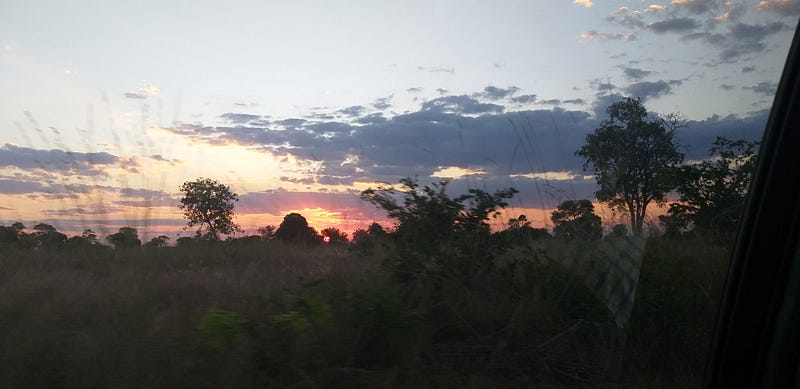
And then, it was dark.
As a result, it was no longer possible to drive towards the North or the West or somewhere in between using the setting sun, nor was it easy to see the tracks we were trying to drive on. Telephone signals had all but disappeared, making our Google Maps even less useful. Suddenly, one of us remembered that they had a compass app on their iPhone! So, with the phone owner in the front passenger seat, using the compass on his phone, we continued more or less northwards and westwards, using tracks that coincided vaguely with those directions.
Each time we reached a fork in the road, I would consult the compass operator, who would suggest which track was going in the desired direction. Unbelievably, even in the pitch darkness, we would still encounter the odd pedestrian, carrying an axe or a shovel. How these guys could see where they were going, is a mystery.
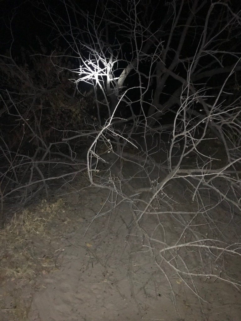
Suddenly, the track was blocked by a tree that had fallen across it. It was too big to drag out of the way, so we took our torches and scouted a route around the obstruction, through the bush. This required the removal of some smaller bushes and shrubs. Sorry about that, Zambia.
Driving ever northwards, our Google Maps indicated that we would soon cross a “road”, named the “M11”, that we could use to travel westwards towards the Park. I grew up in Johannesburg, South Africa, where the M1 and M2 are major highways, but I did not expect the M11 to be in the same category.
It wasn’t.
We crossed the “M11” without even noticing that it was there and we had to backtrack until Google told us that we were on it. The “M11” turned out to be yet another sandy track, more or less following a line of electricity poles that had been erected, but not yet graced with cables.
Our choices were limited and we followed the track westwards. We encountered multiple forks in this braided system of tracks and really tried to find the “road more traveled” but at least twice this turned out to be a wrong choice and we had to turn around in the deep sand, retrace our tracks and try again.
This may all sound very adventurous and even fun, but it’s pretty worrying when you are slowly and quite literally bundu-bashing through the African countryside, in the darkness, with only a cone of light ahead of the vehicle and no clear indication where you are headed and when you’ll get there!
Finally, around 20:30, we saw an actual road right in front of us. Hallelujah! Only a dirt road, but 100% better than anything we’d been on for the last 12 hours or so. We turned North on this and soon saw the sign for the Southern Headquarters of the Kafue National Park.
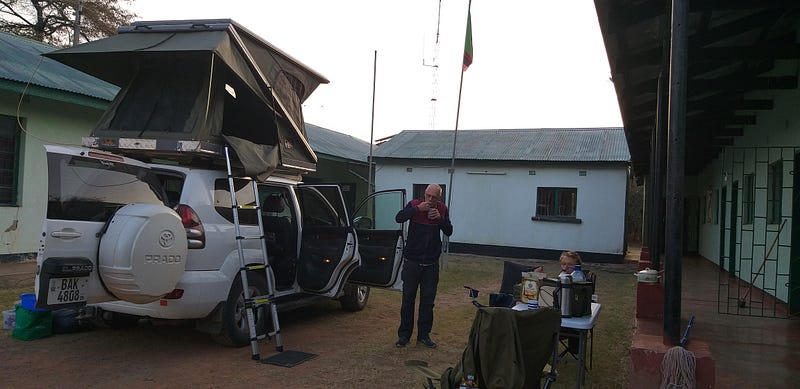
Since it was well after sunset, entry into the Park itself would not be possible, but we were keen to overnight somewhere near some relative civilization, so we drove towards the Headquarters buildings. Here we found a very friendly security officer, armed with an AK-47, who suggested that we park the vehicle right between the quadrangle of buildings, almost under the flagpole.
Invitation gratefully accepted! He even offered that we plug our extension cord into a socket in his office and brought a bucket of water for the toilet, which was not working since the water pump is apparently switched off after office hours.
We saw an antelope just wandering between the buildings and I asked whether he saw much wildlife here. He confirmed that a male lion had wandered past, under his office window, a few nights ago. We were grateful for the lights, therefore! It was after 21:00 by this time, but we hadn’t eaten anything for many hours, so we set up our little gas stove and enjoyed some very welcome instant soup.
My co-travelers crawled into the rooftop tent and I just settled with my pillow and sleeping bag into the passenger seat of the vehicle. I can’t remember when I ever slept better.
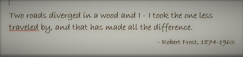
We did not travel on the road we’d planned to, and we’d stumbled along the route largely by accident and luck, but I must agree with Frost — it made all the difference to our day and to our journey. Instead of just getting from A to B, we’d had a truly unique experience.
Next time, however, I’ll bring a decent (paper) map.