
The North, South, East, and West Of It
How GPS has dumbed us down
I shouldn’t be surprised that no one seems to have a sense of direction except me. And I will accept my kudos.
It started when I was very young as a kid whose parents were divorced and lived hundreds of miles apart. There wasn’t a whole lot for a kid to do in the back seat of a car. There were books, but that made a lot of kids carsick. Toys? They can only occupy a bored kid for so long.
What does this have to do with directions? Read on…
Rocks
The madness started with my dad. He was a geologist and could point out the various landforms and features we passed by. Sometimes we’d stop and take a closer look. (In case you didn’t know, parents back then did not like to stop for anything, not even a screaming kid’s bladder. They had to “make time.” Geez, they weren’t truck drivers!)
We’d get into the nitty-gritty and look at rocks up close. I’d choose to take a few but always liked the nice shiny ones in the souvenir stores the best. To this day, when I go on road trips, I bring home rocks. They are cheap souvenirs that often wind up in my landscapes. Just yesterday, I went to the West Mesa to collect a few boulders.
“What do rocks have to do with directions?”, you might be saying.
A lot potentially. But first, let’s talk about…
Food
In the 1960s, when most of this meandering occurred, there were few conveniences and niceties on the wild west's highways. I didn’t even know what McDonald’s was until 1968. Fast food wasn’t a thing. Stuckey’s was about the most frequent restaurant/gas station you’d see, but they were all sit-down restaurants, and that sucked good time! Most smart motorists would bring their food.
You know those picnic tables you see primarily on two-lane roads that no one is ever using? We did back then. Those were our restaurants.
The fried chicken was one of the constants on our road menu. Homemade fried chicken. Cold. I didn’t much care for it. But as long as there was a piece with the wishbone intact which I’d play with my sister, it was good. Drinks were “cokes,” as we called them in Texas, better known as soda or pop elsewhere. And water? Who drank water? It’s a wonder we didn’t all shrivel up and die by the roadside. (Dad always had a thermos. I wonder what was in that?)
Now we’re starting to get somewhere…
Maps
I don’t remember ever getting lost on our travels. That’s because we used real maps back then. They were free at every gas station. Free was appealing, so I began to go inside at every gas stop and grab a few. Every oil company had its version, so my collection grew exponentially—another reason why I’m such a nerd.
Learning to read maps and to help navigate gave me a sense of purpose.
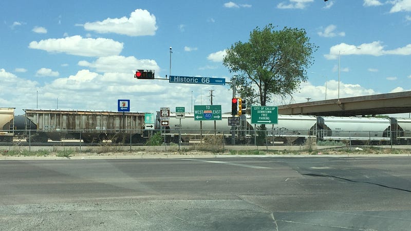
Route 66 (now I-40 in the sections we traveled) was our most commonly used road, and I found it interesting to see the progress being made as each year rolled by. The towns were the last pieces of the Interstate system to be built, and they had to be circumnavigated. The cost of displacing so many residents was cost-prohibitive, so the Interstates were built around the towns. This killed most of the small towns and cities and their businesses located on Route 66.
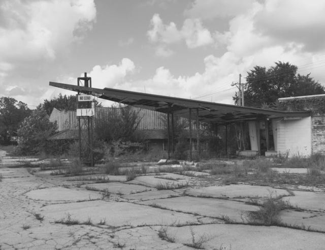
Portions of “The Mother Road” still exist, as do relics such as dilapidated “motor courts” and gas stations gave back to the earth, overgrown with weeds and trees.
About Directions
Signs along the highways were useful, of course, but they alone couldn’t be depended on. It was the combination of maps and signs that delivered you to your final destination.
This is where the north, south, east, and west of it come in. No one seems to know, and for the most part, all you have to do is look up at the sky!
Here in Albuquerque, it seems most people use landmarks as directions. “Go down Central Avenue, take a left at the 7–11, and then a right at the Taco Bell.”
First, you can’t go “down” Central Avenue because it’s an east/west street. Down implies south. Up implies north. Over would imply east or west. And do you have any idea as to how many 7–11s and Taco Bells there are here?
Physical landmarks are the most common way to orient yourself if you’re lucky enough to have them. Everyone here knows that the mountains are to the East. As for the other directions, good luck.
I grew up (partially) in Ventura, California, so the Pacific was always west, and we knew that. When I moved to Chicago, having the water on the East tripped me up for a good long time! At least the streets were on a rigid grid numbering system, so if you could conquer that, you’d always know where you were.
For a guy who knows his way around, I am directionally dyslexic — that being right and left. That is why I always use north, south, east, and west.
At night, those 7–11s and Chevron stations take on a new directional meaning. I’ll excuse you if you use those standards as directions at night.
Technology
The first place I ever went on a business trip on my own was to the Minneapolis/St. Paul area. While driving, I had to read a gigantic street map that took up most of the front seat area. The north-south and east-west freeways run together at one point. Talk about a clusterfuck! And they think today’s drivers are distracted.
In the late ’90s, along came to a new software program called “MapQuest.” Just plug in your origin and destination, and it would plot your route for you with each turn in tenths of a mile. It would tell you the approximate duration of the trip. And you could print it out! This was groundbreaking in the trend that it started. Poor Rand McNally.
Who needs maps? All you need is a smartphone, and it will even dictate the directions for you.
When I travel, I have already planned my route, and I will have maps with me as a backup. Because one should always know in which direction they are traveling (if they can’t read the sun). Do you know what else I always travel with?
A smartphone.


