
Mathematics
The Importance of Spherical Trigonometry Today
And why I may have to start using it again, for real, to know where the sun is directly overhead at any time. We have a lot to thank James Andrew for
A changing world, but some progress is not forward
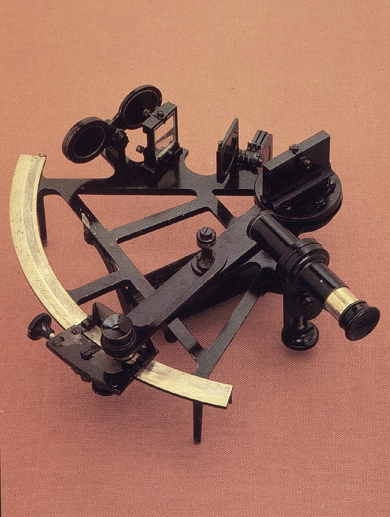
I live on a boat and cross oceans every now and then. I’ve crossed the Atlantic three times and the Pacific once and done many passages of 1,000 miles plus. GPS is very convenient for navigation but I always carry paper charts and a sextant on my boat. Some people have dispensed with paper charts altogether and the US government will no longer issue paper nautical charts after 2025.
So what?
I recently read an advisory from the United States Department of Transportation Maritime Administration (MARAD) warning of various episodes of GPS interference worldwide.
And it’s getting worse. There is a war on. GPS can be jammed and spoofed, even mid-ocean.
So now, as I prepare for another long ocean passage — free at last after Covid lockdowns — I’m dusting off my sextant so that if the worst happens then I can calculate my position at sea.
How does the system work?
Well, it’s simple really. Just solve a spherical triangle.
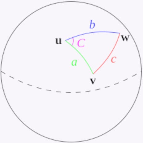
There are a number of different formulas that can be used for position finding with spherical trigonometry. The most common ones are the haversine formula and the law of cosines.
The haversine formula is particularly useful for short distances, while the law of cosines is more accurate for longer distances. However, both formulas can be used for any distance.
Got it?
There is a lot of figuring involved and the old seamen used to use books of tables. But it also depends on an accurate timepiece, which is why Harrison invented the marine chronometer.
Just so you know
The haversine formula determines the great-circle distance between two points on a sphere given their longitudes and latitudes. Important in navigation, it is a special case of a more general formula in spherical trigonometry, the law of haversines, that relates the sides and angles of spherical triangles.
The first table of haversines in English was published by James Andrew in 1805. The term haversine (‘half versine’)was coined in 1835 by James Inman.
These names follow from the fact that they are customarily written in terms of the haversine function, given by hav(θ) = sin²(θ/2).
Nowadays it’s easy to solve the spherical triangle on a PC or even a smartphone.
Stars can be used as well for fixes, usually near dusk or dawn when a clear horizon is visible.
So, to be able to mark my position at sea on a nautical chart I have to know my latitude and longitude. Measuring approximate latitude on land is easy enough with just a stick, but not so easy on a boat. Obviously you have to be able to see the sun and make an adjustment for the sun’s declination. It’s called the noon site.
But it’s not really that simple.
Lat and Long as we sailors call it
The real skill is in taking an accurate measurement of the sun’s altitude on a moving boat on the ocean with a precise timepiece. We’re looking for angular measurement accuracy of less than 1 minute of arc with the sextant (0.1 minutes with the best instruments). And that involves knowing and adjusting for a range of errors (such as index error) and making several corrections (such as for height of eye). Thankfully, tables are available (and a PC astro-navigation application has them on hand)!
Calculating longitude is more complex, as is calculating latitude for times other than noon. That’s where spherical trigonometry comes into play.
One sextant ‘fix’ does not provide a position, it provides a position line, which maps as a circle on the earth’s surface. So, fixes have to be combined to obtain a point (usually 2) where the circles intersect, and that then is a definite position — common sense prevails as to which. To do that allowance has to be made for time and distance travelled between the fixes. Nevertheless, the most skilled marine navigators can obtain an accuracy to well within a nautical mile with a good sextant.
And yes, GPS uses spherical trigonometry to calculate your position, even when you’re in a car on the highway.
Thanks James Andrew, Mathematician. You made such a contribution to mariners in 1805, and yet you have no Wikipedia entry. But others say that Mendoza y Rios beat you to it in 1801. Who knows?
About me: If you follow me I guarantee variety in your inbox! I write on a wide range of topics including humor, tech and travel, together with daily news events and the minutiae of my daily life living on a boat. I also write techno-thrillers…and about…
…haversines and ocean passages
If you enjoy reading stories like these and want to support other writers and me, consider signing up to become a Medium member. It’s $5 a month, giving you unlimited access to incredible stories on Medium. If you sign up using my link below, I’ll earn a small commission at no extra cost to you.
You can follow me on Facebook Twitter @jamesmarinero . On Pinterest you will find many of my research photos from around the world. Check out my website where I occasionally have a free book on offer.
Buy me a coffee? Or maybe buy a book in my store — we both get something that way?