
People, Place, and the Power of Paths
Many footpaths across the British countryside have existed since Medieval times and before. Even when the paths are ploughed into oblivion, people tramp them back. Why?
Near where I live in Hitchin (40 miles north of London), a vast hayfield dotted with a few ancient trees turned itself into a heathland over a space of four years. It was as if a section of Hampstead Heath had hopped onto a train from London and decamped for a looong holiday.
During this time, the paths across and around the hayfield widened and deepened. Scenic ‘off piste’ trails also appeared, revealing routes taken by unsociable walkers and by walkers of unsociable dogs.
Although the field’s new wild identity started to emerge during the COVID pandemic, it was the murder of the field’s owner — a wealthy 69-year-old farmer called William Taylor — in 2018 that triggered the return of the land to a rambling heath.
Eight months after he was reported missing, Taylor’s body was found near the hayfield in the local river Hiz. Taylor’s estranged wife Angela and her lover Paul Cannon were convicted of murder, partly on evidence from scores of explicit WhatsApp messages fantasising about torturing and killing Taylor. The couple are currently serving life sentences.
And then , a few months on, a second tragedy struck …
A tractor ploughed every inch of the field — grass, weeds, and all the paths — into agribusiness oblivion.
Nothing was left but a huge brown tract of seemingly impassable clods as far as you could see, and those poor stranded trees.
“Have you been to the field?” asked local friends in low voices, shaking their heads and blowing out their cheeks with disbelief.
You’d think it had been carpet-bombed.
And yet within around a week, the erased hayfield paths had all been reinstated, as well as those in a neighbouring sheep field that had been ploughed too.
Somehow, intrepid locals had scrambled and tottered across all the clods of earth and stomped the paths back into existence.
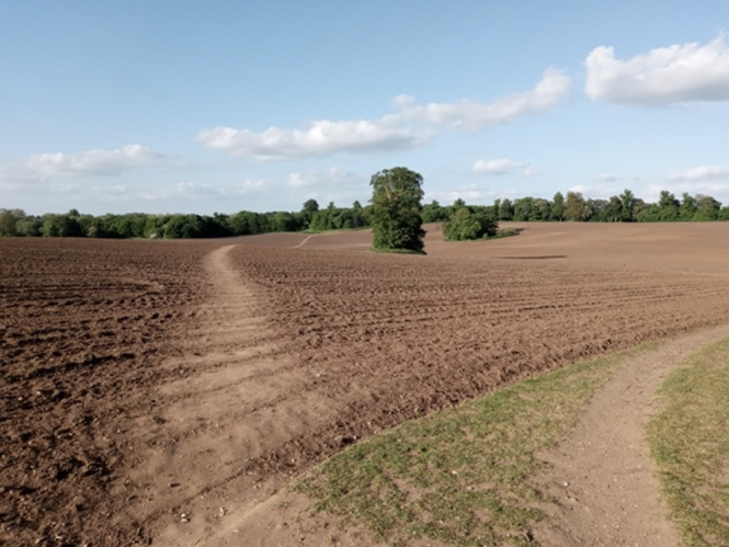
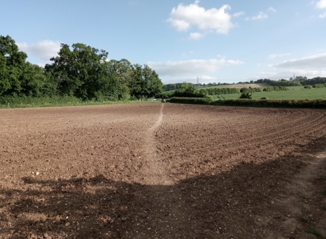
The following pictures show some of the re-etched hayfield paths a matter of days after it was ploughed. The first two are from opposite ends of the main path. You can see the ploughing furrows that walkers had to climb over. Note how long the path is and how it follows the ups and downs of the terrain.
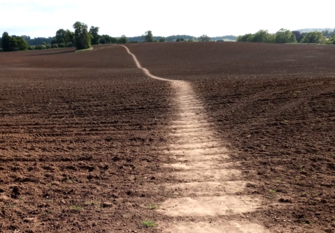
This third picture shows the wide main path again. On the right is a narrower, less walked sub-path.
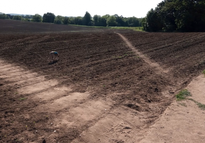
The path restoration wasn’t organised. How do I know? Because I was one of the restorers, with help from my two dogs. While walking on the field, I only ever glimpsed one or two other people doggedly stumbling along doing the same thing. It required a certain bloody-minded ‘This is where the path goes, I’m damn well going to walk it back!’.
All the newly-restored paths were erased again when the tractor returned a week or so later to break up the clods into smaller pieces (known as harrowing), ready for planting a crop.
With the flatter soil, the paths were trodden back faster than before. The next picture of two faint paths (one straight ahead, and the other on the right in the shade of a tree) was taken in the neighbouring sheep field just one day after the field was harrowed. The local walkers had already done their work.
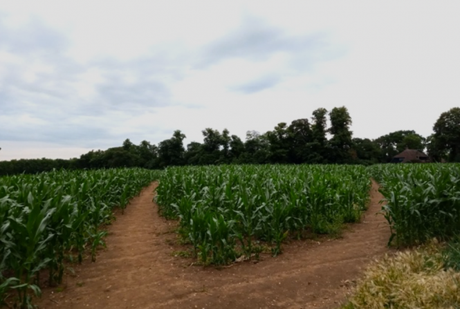
When maize was then planted in the fields, you could see the paths outlined and welcoming, surrounded by the greenery.
Place-iness
Around 140,000 miles of public footpaths, byways, and bridleways criss-cross England and Wales. Many have existed for hundreds or thousands of years. Some were ancient routes for driving cattle, sheep and geese to market. Others in remote areas were coffin roads for carrying the dead to their burial places. But the majority, infiltrating like tiny capillaries into the furthest corners of the British Isles, are like those through the hayfield: local footpaths used for getting from A to B as quickly and easily as possible. They were typically on commonly owned land.
Accurate mapping, legislation, and the determination of the British Ramblers Association account for some of this permanence. In the aftermath of WW2, all the UK’s footpaths were mapped as a provision in the National Parks and Access to the Countryside Act of 1949. Out of this came the Definitive Map: a legal record of public rights of way in England and Wales that has to be kept and updated by every local highway authority. In other words, traditional rights of way in England and Wales are protected by law. The only parts not covered by the Definitive Map are boroughs of inner London.
Before that, a defining event was the mass trespass of around 500 people who walked 8 miles from the village of Hayfield (no relation — but what a coincidence) to Kinder Scout in the Peak District, Derbyshire, England, on 24 April 1932. The protestors wanted to highlight how walkers were being denied access to areas of open countryside which had been fenced off by wealthy landowners. The imprisonment of some of the trespassers led to public outrage, which increased support for open access land. You can walk in their footsteps today with help from this National Trust map.
That same determination to protect access to countryside remains. In January 2023, the Environmental activist organisation Right to Roam organised a mass protest on Dartmoor, Devon, in opposition to the loss of wild camping rights, after the high court ruled that this long-held custom was unlawful unless people asked permission from the landowners (Alexander Darwall, a hedge fund manager, and his wife Diana). An estimated 2,000 people took part in the protest. Just a couple of days ago, an appeal restored the right to camp, making it the only place in England where wild camping is allowed without permission.
The legislation 75 years ago worked because the paths were already there and public support is so strong.
You can’t simply legislate paths into continued use. You need people with a strong sense of ownership about where they live to keep walking the paths day in day out. I’m going to call it ‘place-iness’ –
New research by Joe Day, lecturer in historical geography and economic history at the University of Bristol, gives us more of a sense of ‘place-iness’.
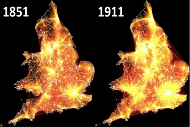
Day and colleagues measured the distance migrated between a person’s place of birth and their place of residence on census night, for the entire population of England and Wales in 1851 and 1911.
The map below shows the resulting migration networks. The brighter the lines, the more migrants. You can see a South Wales clump, a southwest England clump (Devon and Cornwall), a southeast clump around London, a Midlands clump, a Yorkshire clump and one around Newcastle in the northeast.
All these areas are distinguished by regional accents, local words, distinctive senses of humour, local foods and dishes, types of industry or farming, distinctive fabrics and clothes, as well as recognisable landscapes and even building materials like thatch or cob.
The maps show that boundaries between cultural regions act like barriers to stop people moving and migrating elsewhere.
Dr Day is astonished by the degree of similarity between the geography of human interactions today and in the past. “The migration patterns show a remarkable stability over time, and illustrates regions of England and Wales most people would recognise,” he says. “For example, Yorkshire is identified as an independent ‘cultural sphere’, while Devon and Cornwall similarly represent a distinct ‘South West’ character.”
The 19th century was a time in which the pace of urbanisation in Britain has never been as fast, before or since, says Day. “It was nonetheless slowed by individuals’ sense of identity and reluctance to migrate across cultural boundaries.”
Those who left home or farms or domestic service travelled relatively short distances, he says. Most of the population stayed put because of a sense of ‘belonging’, a fundamental social need. Or to put in another way, the age-old question of ‘who am I?’ cannot be separated from ‘where do I belong?’, says Day. Our sense of belonging is strongly geographical, which also ties to community and cultural roots.
Perhaps the most extraordinary example of long term ‘place-iness’ in the UK was the discovery in 1997 of an ancestor of a 10,000-year-old skeleton (Cheddar Man) found in a cave in Cheddar Gorge, Somerset. DNA testing revealed that Adrian Targett, a retired history teacher who lived in the area, was a maternal DNA match.
Targett’s family line had lived near Cheddar Gorge for around nine millennia, genes being passed from mother to daughter through mitochondrial DNA.
All of which got me wondering about the age of the Hitchin hayfield paths.
Measuring the age of paths
Anyone can estimate the age of rural paths in the UK by examining what’s growing in the bordering hedgerows. You simply count the number of woody shrub species in the hedges over a few 30-metre stretches.
This rule of thumb is called Hooper’s Law after Max Dorien Hooper (1934–2017), a British biologist and historian. He said that each woody species adds around 100 years. So a hedge with eight species, say, hawthorn, sycamore, blackthorn, hazel, ash, alder, willow and oak, would be approximately 800 years old.
Why does it work?
Hooper couldn’t account for the number of shrub species in hedges based on how they were managed and soil type. The only correlation he found was the age of the hedge. As a result, he concluded that shrub species’ diversity increased over time as seeds carried by birds and the wind took root under the hedgerows. Regular trimming would help new species establish by controlling existing species. The formula also works because ancient hedges are more likely to be remnants of mixed woodland, or because hedges before about 1700 tended to be planted of mixed species.
As you go further back, the formula grinds to a halt. It can’t distinguish Anglo-Saxon hedges from Roman hedges. And a late Bronze Age hedge from 1000 BC would need to show 30 species in 30 yards to fit the formula, which would be impossible.
Old maps and other historical references can help verify hedge ages. Parish boundaries, which date anywhere from the 7th or 8th to the 12th centuries, are found in old church records. In the 1840s, Tithe Surveys showed every farm, every field and every hedge. Some land boundaries can even be traced back to neolithic times.
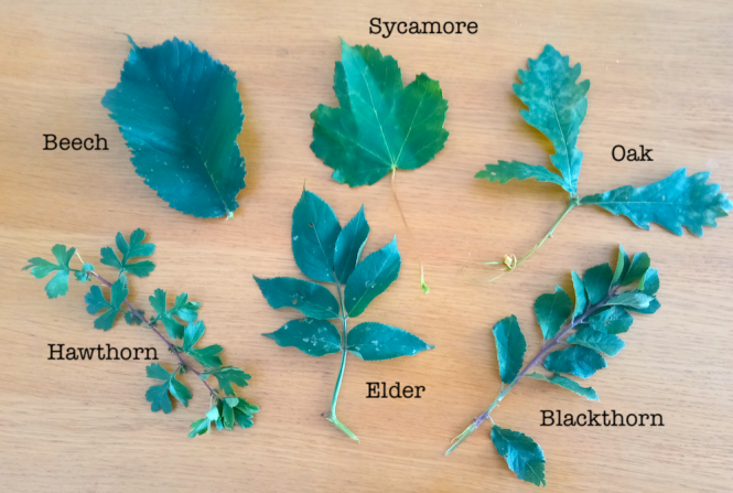
With help from a friend, I counted the species in several 30 yard stretches in a number of hedgerows bordering the Hitchin hayfield. The results suggest that the paths could be anywhere from 200 to 600 years old. Below are the six species — beech, sycamore, oak, hawthorn, elder and blackthorn — in the oldest hedge section.
Bordering the hayfield to the north are the grounds of Hitchin Priory, a former Carmelite monastery founded in 1317. To the south is the estate of Maydencroft Manor farm, which dates back to 1269. Both suggest that the hayfield paths could indeed date back 600 years to the early 15th century or even before,
Using a google search for old maps, I traced the long main path across the hayfield to at least 1766, based on the following section of the 1766 Dury and Andrews map of Hertfordshire (from the Delme Radcliffe collection in the Hertfordshire Community Archive).
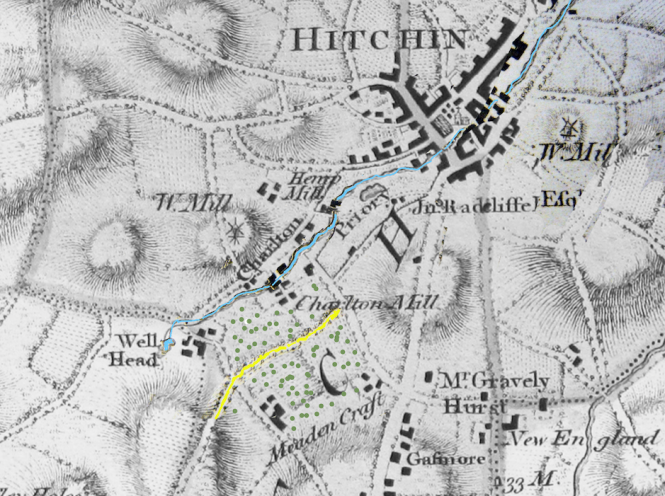
The yellow line is the path and the hayfield is dotted with green. The blue line is the river Hiz. The Priory grounds are just above the hayfield, slightly to the right. Beneath the hayfield you can see the words ‘Meaden Craft’ (now Maydencroft Manor farm).
Below is a modern satellite map (taken before the hayfield was ploughed and planted with maize) showing the lower left area of the 1766 map. Note the Priory grounds, the main path (in yellow) and the river Hiz (in blue). Look closely and you can even see the sub paths and clumps of trees in the field.
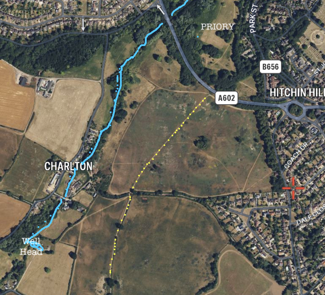
The name ‘Hitchin’ dates back to 658–675 AD when a Saxon tribe, called the Hicca (people of the horse) first occupied the land. The 12.5 mile Hicca way path that follows the river Hiz (in blue on the maps above) is thought to be of a similar age. It runs parallel to the yellow main hayfield path. Maybe the hayfield paths are even older than the hedges and the ancient Priory and farm might suggest?
Desire paths across the hayfield
How did the paths get there? One answer comes from a study by Michigan State University when it renovated part of its campus in East Lansing a while back. The university left the space between buildings as grass, and then waited to see where the students naturally walked. The paths were then asphalted and formalised a year later.
As you can see from this picture, the students naturally chose the shortest and most logical routes. Often the paths are curved, probably following the contours of the land.
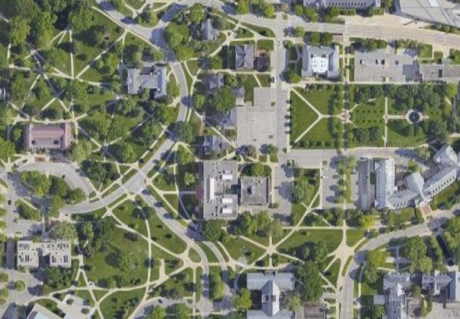
Some researchers call these ‘desire paths’ — routes where people naturally want to walk.
The hayfield footpaths are probably the routes where people have wanted to walk across the field for hundreds of years.
Nicholas Rudd-Jones, co-author of the book Pathways (2011), points out in his article ‘The History Behind Britain’s Pathways’ that before the telephone, radio, television and the internet, paths joined people together socially, politically and economically. “On a personal level they were incredibly important to those who walked them, as they formed a map of every relationship — social, familial and commercial — in their lives. In a wider sense, they were integral to every shift in power, every ‘revolution’, every change in consciousness that took place in the British Isles for hundreds, even thousands, of years. A world without paths would, in a very real sense, be a world without any history at all,” he says.
Ultimately, our need to ‘belong’ seems to be geographical. Human are inherently ‘placey’. It’s one of the reasons people don’t like moving far from the area they were born as Joe Day discovered in his research into migration. And places become distinctive because communities have settled there over centuries, which is how cultures develop. It’s a continuous feedback loop.
So we should not be surprised about the sense of ownership many of us feel over local pathways and rights of ways. They are part of our cultural ‘belongings’ and also where we belong. Every day we walk on them, we march them deeper into the landscape and into local memory and history.
Of course, place-iness can be a source of selfish NIMBY (Not In My Back Yard) activism against new housing and other necessary developments. At worst, it can become aggressively territorial.
We are all under pressure to live increasingly virtual, abstract and globalised lives. Footpaths are one of the few things that can ground us in place and time. No wonder our desire to tramp them back is so strong.
© CEP at H&W first published 28th July 2023. Revised 13th January 2024. All rights reserved.
References
Much of the land in UK used to be held in common. Between 1604 and 1914, Parliament passed a series of enclosure acts that handed around 6.8 million acres of land (over a fifth of the total area of England), into the control of wealthy landowners to use for their own profit, see https://theecologist.org/2020/aug/25/protecting-our-right-roam. An article in the Guardian in 2019 showed that half of the land in England is now held by just 1 percent of the population, around 25,000 people. https://www.theguardian.com/money/2019/apr/17/who-owns-england-thousand-secret-landowners
William Taylor murder: Wife and lover jailed for life: https://www.bbc.co.uk/news/uk-england-beds-bucks-herts-50344906)
‘Mapping the cultural divides of England and Wales: Did the geographies of ‘belonging’ act as a brake on British urbanisation, 1851–1911’, by Joseph Day et al; published in PLOS ONE May 25, 2023 https://doi.org/10.1371/journal.pone.0286244
‘Pathways’ (2011), by David Stewart and Nicholas Rudd-Jones; Guardian Books, ISBN: 978 0 85265 226 8
‘The History Behind Britain’s Pathways’ by Nicholas Rudd-Jones: https://www.ukhillwalking.com/articles/features/the_history_behind_britains_pathways-3091
‘The Making of the English Landscape’ by W. G. Hoskins (Nature Classics Library) Paperback, 1 May 2013
https://www.maydencroftmanor.co.uk/Maydencroft-Manor-Native-Breeds-Farm.html
https://www.theguardian.com/science/2018/feb/09/hes-one-of-us-modern-neighbours-welcome-cheddar-man