
My Hometown — Church Stretton
Shropshire’s Little Switzerland
I moved from London to Church Stretton twenty-five years ago. Another couple of decades and I may soon be considered a local!
Church Stretton lies in the English county of Shropshire. Now, many UK residents struggle to pinpoint Shropshire on a map. When I told work colleagues in London I was moving to Shropshire, the first words most of them said was, “Where’s that?”
So I gave them directions: take the M25 London Orbital, head up the M1, turn left onto the M6, go through Birmingham, then just after Wolverhampton, turn left again onto the M54. When the M54 runs out, you’re in Shropshire. (Actually, part of the M54 is in Shropshire, so I can’t say Shropshire has no motorway, but unlike the eight-lane M25, and the six-to-eight lane M6, the M54 is only four lanes . . . in other words, a glorified dual carriageway).
The M54 becomes the A5, which then skirts the county town of Shrewsbury. If you miss the junction on the left for the A49, then chances are you’ll end up in Wales. Take the A49 south, though, and after a meandering twelve miles, you’ll arrive at my hometown.
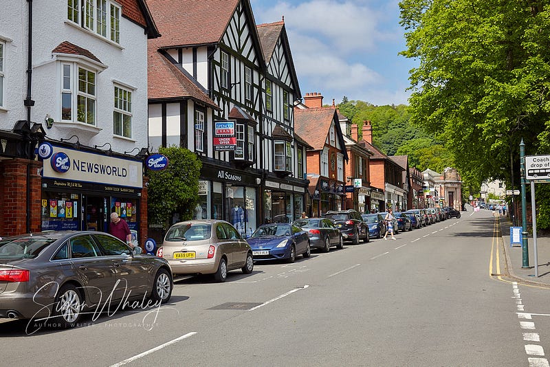
Church Stretton is a market town with a population of about 2,500, rising to 4,000 if you include a couple of the surrounding villages. (But for someone like me, who grew up in a London suburb, it’s a village 🤣.)
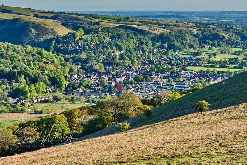
Nestling in the Long Mynd
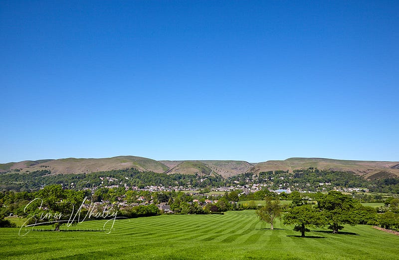
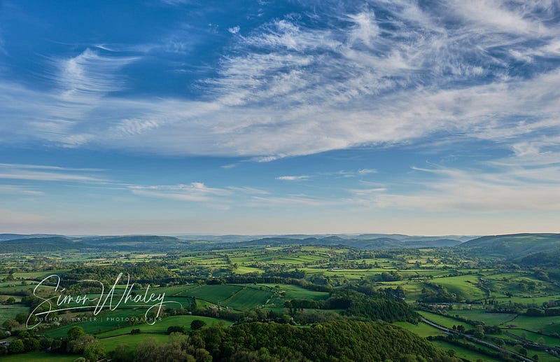
Guides books often refer to Church Stretton as ‘nestling’ in the Stretton Valley. Since the 1960s, it has expanded somewhat, so constrained is probably a better description now. Along its western edge, the town is bordered by the Long Mynd, an upland plateau, shaped like an isosceles triangle, stretching for seven miles in length and a couple of miles at its widest point. It covers an area of some 2,000 hectares (just under 5,000 acres), and is an important wildlife habitat.
Some of it is owned and managed by the National Trust, so it has the obligatory tea room (and very nice tea and cake they offer too) in Carding Mill Valley.
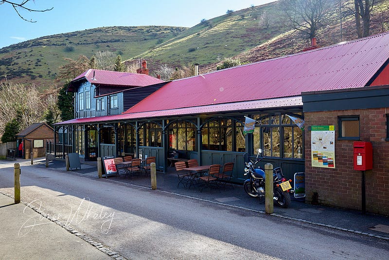
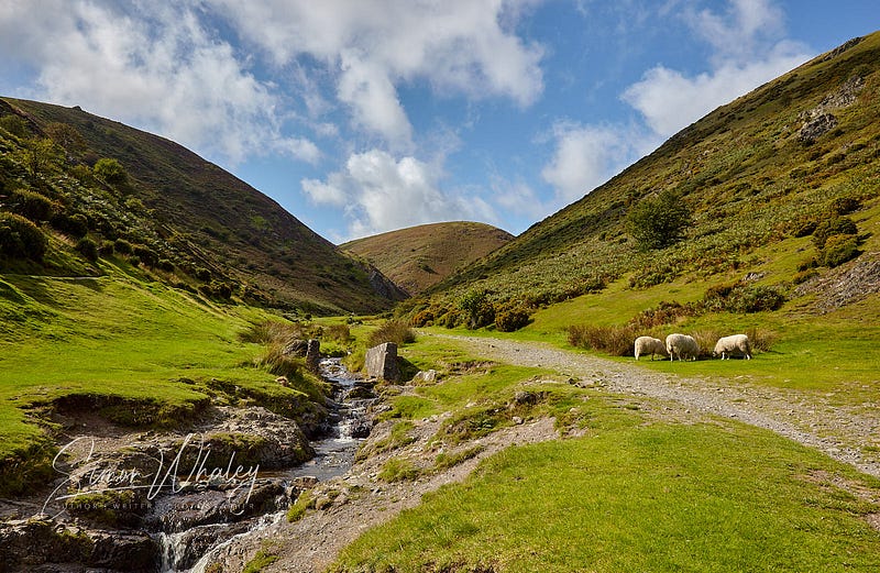
Carding Mill Valley is the tourist hotspot. It’s a popular destination for day-trippers from Birmingham and Wolverhampton, and unfortunately, it does mean things get a bit crowded at times in this valley. (We even made the local and national news during the Covid pandemic because we were inundated with English tourists who were unable to travel into Wales.)
However, if you’re not tied to a car, then Church Stretton is blessed with a railway station, with regular services connecting Cardiff and Manchester, as well as some of the Welsh Port services (Holyhead, Pembroke Dock) passing through.
The Long Mynd’s name comes from a corruption of the Welsh word mynydd, which means mountain. While we’re definitely on the English side of the border, we’re only a few miles away, so Welsh does infiltrate local place names.
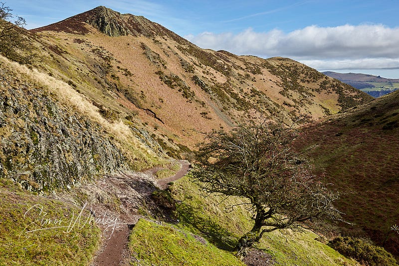
Technically, the Long Mynd is not a mountain — the highest point is Pole Bank, which is 516 metres (or 1,692 feet). (To be classified as a mountain in the UK the peak needs to be higher than 610 metres, or 2,000 feet.)
However, there are several valleys cut into the Mynd on its eastern flank, although locally, these are known as batches or hollows. Carding Mill Valley is the biggest (hence the tea rooms and car parking), but if you’re looking for something quieter, check out:
- Townbrook Hollow
- Ashes Hollow
- Small Batch.
Little Switzerland
This ruggedness, relative height, and lack of huge urban sprawl means that in winter, if anywhere gets snow in Shropshire, it’s us! So much so, that during the Victorian period, Church Stretton attracted the alternative name of Little Switzerland. And yes, on a sunny winter’s day, when the hills are covered in snow, it does look picturesque.
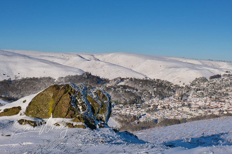
However, it can be dangerous. It may not be a mountain, but lives have been lost. One of the most famous survival stories is that of the Reverend Donald E Carr, whose tale of survival is known as the Miracle on the Mynd.
Stretton Hills
While Church Stretton is bordered by the Long Mynd on the west, the east is hemmed in by the Stretton Hills: Ragleth, Helmeth, and Caer Caradoc. (Caradoc being another name with a Welsh influence).
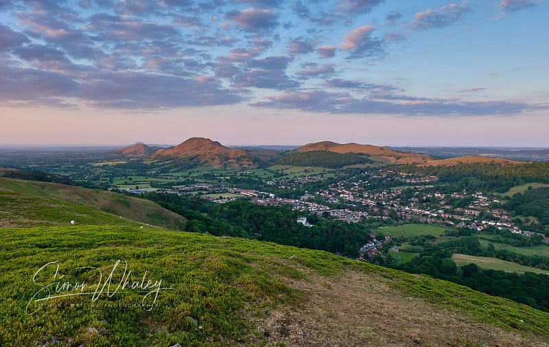
Any budding geologist will soon realise that these hills make up a fault line . . . which continues further northwards, to take in The Lawley, and then, ultimately, The Wrekin, some twenty-five miles away near Telford.
While the UK is not known for its major earthquakes, we do get the odd little tremor from time to time. Twos and threes on the Richter scale are relatively few and far between, but the isolated 5.2 has been known to cause minor structural damage (if you read our house-buyer’s report you’d think we’d bought somewhere on the San Andreas fault!).
Indeed, Church Stretton is a geologist’s heaven, for the immediate area has rocks from eleven of the twelve recognised geological periods. When I tramp the local hills, I literally walk the world.
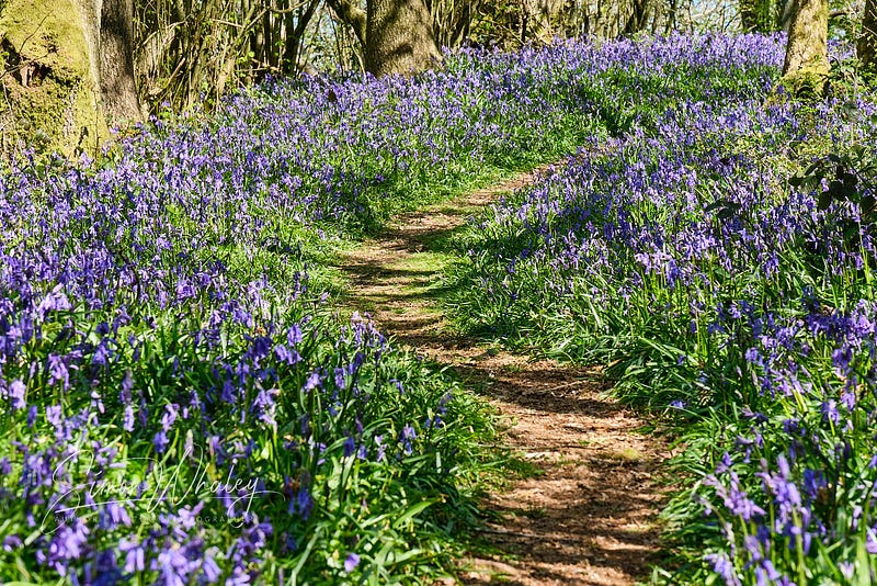
Bluebell Bonanza
April and May is a bonanza for bluebells. Helmeth Hill is the only completely wooded hill here, and it was bought by the Woodland Trust in the 1960s when further housebuilding development threatened it. That far-sightedness means that locals and visitors alike are blessed with these blue swathes every spring.
As you can probably tell, with all these hills surrounding us, Church Stretton is popular with walkers. Once a year, in October, I’m woken in the early hours of a Sunday morning by the weary plodding of weary walking boots hobbling down my road. Church Stretton hosts the Long Mynd Hike, which is a 24-hour endurance walk, stretching for fifty miles as it negotiates the Stretton Hills, the Long Mynd, and even makes an incursion into Wales (I told you it wasn’t far away).
It begins at one o’clock on the Saturday afternoon, and entrants have until one o’clock the following day (Sunday) to negotiate eight hill climbs, totalling 8,000 feet of ascent. The really fit people do it in under twelve hours. The vast majority do it in about eighteen hours, hence why they wake me up early on a Sunday morning.
I am in admiration of those who do tackle it. Personally, I prefer to savour my walking, and if I’m climbing to the top of a hill, I want to see the view from the top (not easy if you’re tackling the route between the hours of eleven at night, and five in the morning!). Still, it proves to be a great fundraising event for local charities.
South Shropshire AONB
Church Stretton is the only market town found inside the South Shropshire Area of Outstanding Natural Beauty (AONB). In the UK, the designation of an AONB means the land is as scenically outstanding as that of a National Park, it just doesn’t have its own planning authority (planning issues are dealt with by the relevant local authorities).
So, scenically, living in Church Stretton is like living in a National Park.
If you climb to the summit of any of the hills you will be greeted with an amazing view, and a clear understanding as to why South Shropshire is an Area of Outstanding Natural Beauty. You won’t see any major conurbations (in fact, you’ll see very little in the way of urban development). You won’t even see any of those hideous metal electricity pylon monstrosities.
South Shropshire is one of the few places in the UK where you can see views like this, that is not a National Park.
Hill Top Assessments
If you’ve the energy to climb one of our hills, here are my top tips:
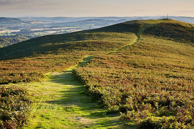
The Long Mynd: Take Townbrook Hollow (easily accessed from the centre of town) and then climb up onto the Mynd’s plateau. It’s still a couple of miles to the summit at Pole Bank, but this is a quieter route. (Return via the busier Mott’s Road and it’ll bring you into Carding Mill Valley — you’ll have earned some tea and cake, by then😁.) From the summit, you’ll get great views of South Shropshire, the Brecon Beacons, and most of Wales. On a clear day, you can see Cadair Idris, one of Wales’ higher peaks, a distance of 45 miles away.
Caer Caradoc: This hill looks ‘rugged’ and practically shouts “Climb me!” While we don’t do high round here (Caer Caradoc is 459 metres, 1,505 feet) we do steep. The popular route up to Three Fingers Rock will get the heart rate going. When you finally reach the summit, just think of the poor souls who used to live in the Iron Age hill fort that once crowned this place. (They had good views of North Shropshire and the Cheshire gap from here.)

Helmeth Hill: as mentioned, this is bluebell heaven. There’s no point climbing to the summit — it’s crowned in thick woods so there are no views. Much better to circumnavigate the hill and enjoy the flora sights and smells.
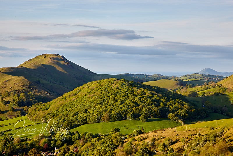
Ragleth Hill: This is my hill (well, I don’t own the hill, but it’s the one I walk nearly every day, so it feels like mine 😁). On still days, the air is filled by the skylarks, whose tiny bodies belt out vast volumes of soulful songs. The views are of South Shropshire, and also of Wenlock Edge, a seventeen-mile long wooded limestone escarpment, which a few millions of years ago was a coral reef under a southern hemisphere sea.
Spielberg’s Favourite
For two decades, the small hamlet of Minton, just south of Church Stretton, was home to Pete Postlethwaite, whom Steven Spielberg declared was the “best actor in the world” after directing him in The Lost World: Jurassic Park. He was always a fantastic supporter of local fundraising efforts.
Pete often commented that walking on Church Stretton’s Long Mynd was the perfect antidote to the stresses and strains of Hollywood.
Ann Cook
And if you happen to wander through the town’s St Laurence’s churchyard, look out for the faded grave of Ann Cook, a local woman who died in 1841, aged 60. The inscription reads:
On a Thursday, she was born,
On a Thursday, made a bride,
On a Thursday, her leg was broke,
And on a Thursday died.
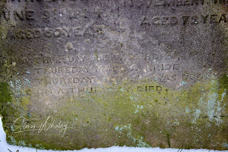
Which just goes to show that it all happens in Church Stretton on a Thursday! (And, it does — Thursday is market day!)
So that’s my hometown. There may be many in the UK who’ve never heard of it, but I’m glad I discovered it.
For more information about Church Stretton visit www.churchstretton.co.uk