
Travel & Nature
Kick ’em Jenny
No, not a tale of domestic abuse although volcanic behaviour may be expected
That’s the music bit done!
A great name but what is it?
Kick ’em Jenny is an active submarine volcano or seamount on the Caribbean Sea floor, 8 km north of the island of Grenada and about 8 km west of Ronde Island in the Grenadine Islands.
It rises 1,300 m (4,265 ft) above the sea floor on the steep inner western slope of the Lesser Antilles underwater mountain range. The Lesser Antilles are a chain of islands in the Caribbean Sea, where these two plates are colliding.
The Caribbean tectonic plate is subducting the South American plate to the east of this ridge.
Kick ’Em Jenny is the only active undersea volcano in the Caribbean.
The volcano is reputedly named after a British fishing boat that was destroyed by the eruptions in 1939. The boat’s crew was known as the “kick em jennys” because they were always getting into trouble.
Discovery
The Kick Em Jenny Volcano has been an area of interest for scientists and researchers since the late 1800s. It was first discovered by a fisherman in 1843. The fisherman, who was sailing through the Caribbean, noticed a dark spot on the ocean floor which he believed to be a shipwreck. When he got closer to investigate, he realized that it was actually an active volcano rising from the ocean floor.
That’s a great tale, but is disputed as there do not appear to be any scientific papers about it (her?) dating from that time. However, an underwater feature is noted on early nautical charts of the area, so there is perhaps a grain of truth in the lore.
I’ve sailed past the spot on three occasions just a few miles away and didn’t see a thing! The first time was just after we’d arrived in the Caribbean having sailed our old boat across from the Canary Islands via Barbados. We had a great couple of weeks in Bequia and headed south for Mayreau, then on towards Grenada.
Generally, it’s held that it was discovered in 1939 when the first recorded eruption occurred, although there were surely many before.
The volcano erupted on the 23rd-24th of July 1939, and it caused tsunamis that reached around 2 metres when they hit the coastline of Grenada and the Grenadine Islands. The tsunami also caused damage in Barbados some 130 miles away.
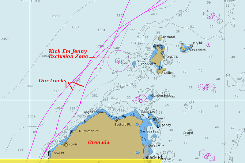
I discovered it in 2016 when I looked closely at the chart on our way down the island chain from Mayreau. Kick ’em Jenny is on the North-South shipping routes from St Vincent to Grenada. There is a Maritime Exclusion Zone which is varied by the authorities from between 1.5 km to 5 km, depending on Kick ’Em Jenny’s behaviour.
When we sailed past in 2016 and 2017 the zone was 5 km (see chart). Bubbles of volcanic gases can lower water density, creating a sinking hazard, although we’ve seen fast inter-island ferries go right over it.
Recent events
The volcano has been monitored by the University of the West Indies for many years.
Signs of increased undersea activity began July 11, 2015, and on July 23 a strong continuous seismic signal was recorded. On July 24, an eruption occurred, with a duration of about 1 hour.
Since then there have been several warnings to mariners in response to occasional bursts of activity.
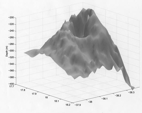
What does a volcano under the sea look like?
Here’s a NOAA sonar image of Kick Em Jenny:
I tried to examine some Google Earth satellite images of the volcano, but the area was obscured by atmospheric cloud.
Ongoing dangers
Over the last few years we’ve all become aware of the dangers of tsunamis — not least me because I live on a boat, currently in New Zealand. The recent undersea volcanic eruption in Tonga caused significant damage here, 1,000 miles away. We were OK, but a local harbour was wrecked.
So, Kick ’Em Jenny is under constant scrutiny by The University of the West Indies Seismic Study Centre. A serious eruption would have devastating consequences for the coastal communities of the islands.
About me: I write on a variety of topics including humor, tech and travel, together with daily news events and the minutiae of daily life on a boat. I also write techno-thrillers…and about…
…natural events at sea and under it
If you enjoy reading stories like these and want to support other writers and me, consider signing up to become a Medium member. It’s $5 a month, giving you unlimited access to incredible stories on Medium. If you sign up using my link below, I’ll earn a small commission at no extra cost to you.
You can follow me on Facebook Twitter @jamesmarinero . On Pinterest you will find many of my research photos from around the world. Check out my website where I occasionally have a free book on offer.


