
Exploring a Norse Ruin in Greenland
Spiritual experiences in an ancient graveyard
“It’s right over there,” said Matthew Walsh, pointing off in the distance. I followed his gaze, but saw only the usual rocks and shrubs. Yet, excitement filled his voice. Matt set off quickly, heading inland. After a few minutes he came to a stop, allowing me to catch up. It took a moment, but then I finally saw why Matt got so excited. A pile of rocks had been stacked deliberately to create an ovular space that contained human remains. I was looking at an ancient grave.
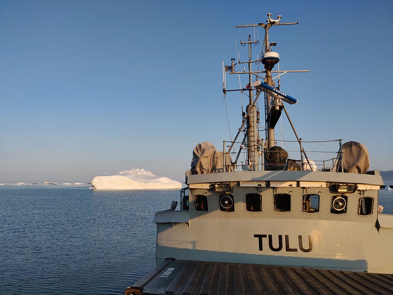
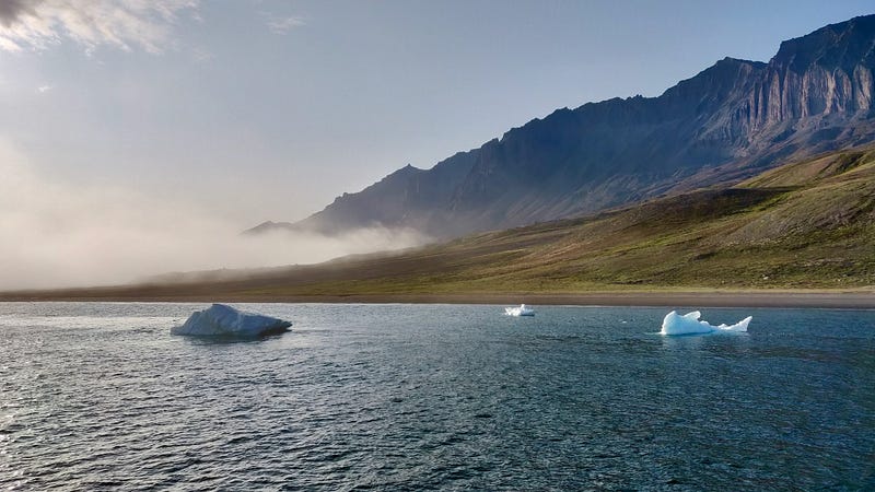
My grave adventure began about two weeks earlier in Ilulissat, a quaint little town surrounded by giant icebergs. On a bright August morning my colleagues and I boarded the M/V Tulu, a former Danish Navy vessel. As an oceanographer, I’ve had more than a few spiritual experiences at sea. I feel more connected and more alive when I’m onboard a ship. This connection is especially strong in Greenland, where the glaciers and icebergs take on a life of their own. I usually return from my time at sea with a greater appreciation for modern comforts. After this trip, I returned home with a much greater appreciation for my family.
This wasn’t my first time conducting research in northwest Greenland, but the science team onboard the Tulu included a few outliers: an archaeologist and an anthropologist. On this “special” cruise, our social science colleagues hitched a ride to survey some coastal archaeological sites.
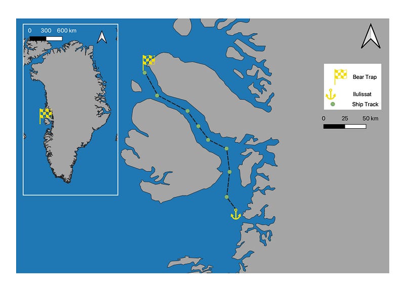
This special research cruise focused on the Vaigat Strait. Wedged between Disko Island to the south and the Nussuaq Peninsula to the north, the Vaigat Strait connects northern Disko Bay and surrounding fjords to Baffin Bay. We sailed north from Ilulissat, then northwest and, over the course of the next two weeks, we conducted our research when the wind and fog allowed.
I joined the archaeology team for several of their surveys, learning heaps from the experience. Modern archaeology combines information and methods from different disciplines to create a more complete picture of past civilizations. Understanding how people lived and died many years ago, using only a few clues left behind, requires a vast amount of knowledge that spans the fields of history, religion, economics, (human) anatomy and physiology, geology, botany, zoology, hydrology, climate, computer science, GIS, and more.
I wasn’t just tagging along for fun. I contributed to the surveys by mapping sites with my drone. I normally use the drone for my iceberg studies. Archaeological surveys and iceberg melting might not seem related, but the same image processing software can be used for both studies. In both cases, I processed the images using Agisoft Metashape, a Structure from Motion with Multi-View Stereo photogrammetry program.
Basically, I take a lot of pictures and I move the drone so that each image overlaps with its neighbors. If there’s enough overlap, the images can be stitched together to create very detailed 3D models and maps of coastal archaeological sites and icebergs (and lots of other things — check my profile if you’re interested in Agisoft Metashape). Structure from motion can also be used with a hand-held camera to document smaller objects. We used different full-frame and APS-C cameras to create 3D models of specific archaeological features at some of the sites.
The photo surveys served two primary purposes. First, some of the archaeological sites had not been visited for decades. Most of the available maps were hand-drawn. While I am impressed with the sketching skills displayed by earlier archaeologists, Structure from Motion recreates entire landscapes in three dimensions. The second purpose, therefore, was to digitally preserve these sites as climate change threatens the future of Greenland’s archaeological sites and cultural heritage.
Opportunities to go ashore on previous research cruises were usually limited. Even when they arose, my duties onboard the ship kept me quite busy. As a result, I had not thought much about the distant shorelines. On this trip, however, our frequent trips ashore provided me with a unique opportunity to connect with another part of Greenland.
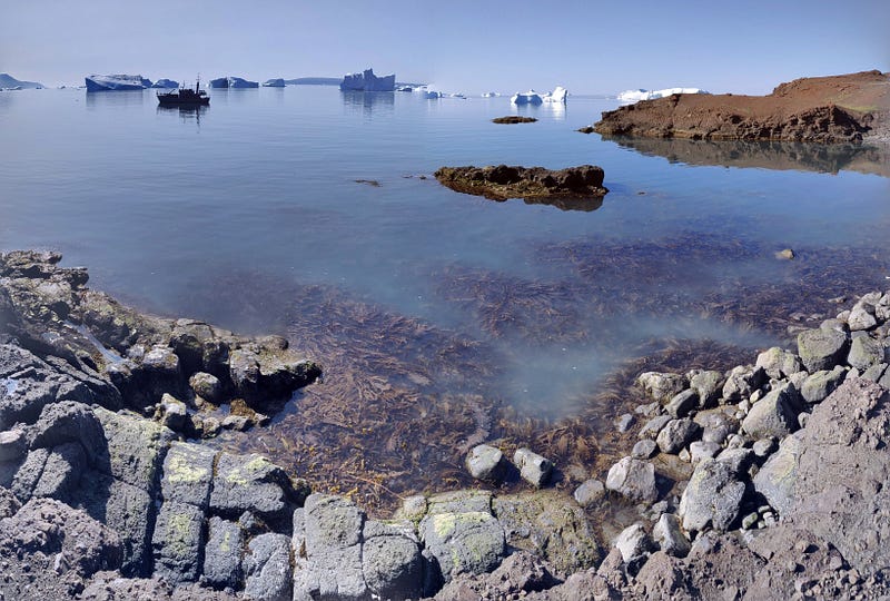
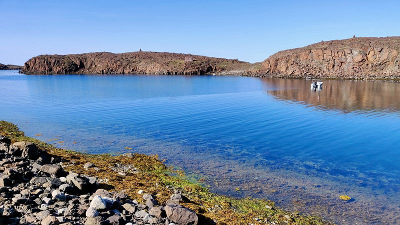
The shorelines of the Nussuaq Peninsula are exceptionally beautiful, especially when illuminated by the long rays of the midnight sun. The strip of inhabitable land is quite narrow though, squeezed in between the sea and the steep cliffs. Walking these remote shorelines helped me to appreciate Greenland’s cultural heritage and the tenacity of its inhabitants, both past and present.
Wandering around the remains of former settlements, remote places where people lived, loved, and died, I tried to picture myself living here. My family soon entered my mind. Would I have been able to keep them warm and fed? I might manage during the summer, but surviving the frigid, dark winter seemed unlikely. It was a sobering thought.
My family was safe in a modern home and I could always retire to my comfortable cabin on Tulu. Food definitely wasn’t an issue, except maybe for the vegetarians in our group. Previous inhabitants of Greenland didn’t having the luxury of dietary restrictions. Their children weren’t allowed to be picky eaters. Visiting these archaeological sites and learning about the lengths to which the Saqqaq, Norse, Thule, and Inuit people went to in order to feed their families left me with a profound appreciation for modern conveniences.
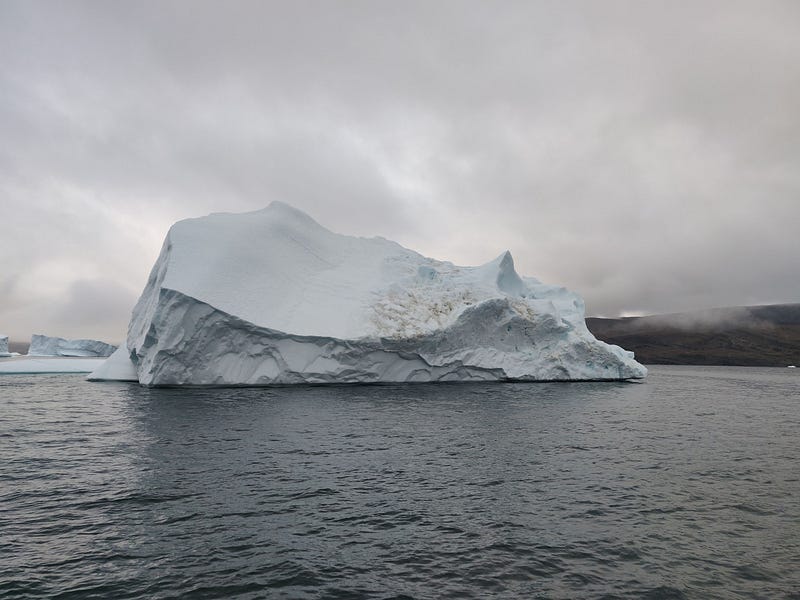
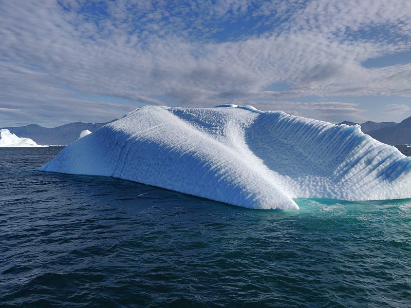
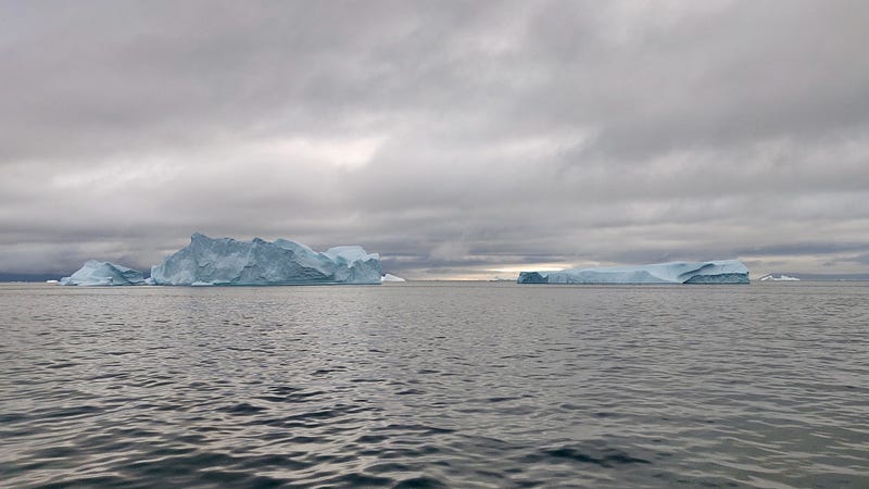
While the shore excursions were definitely the highlight of this trip, the time at sea also rewarded us with some impressive icebergs. The glaciers in this area produce some real monsters and I spent hours on deck, filling up several memory cards with photos. We weaved our way through the ‘bergs, and up the Vaigat Strait.
After almost two weeks, we reached the ‘The Bear Trap,’ which is a Norse Ruin located at the end of the Nussuaq Peninsula. I knew that the Norse sailed from Iceland to southern Greenland, establishing settlements and then later abandoning them. What I didn’t know, at least not until this trip, was that some of the more enterprising Norsemen embarked on a treacherous journey during the summer, sailing up to Northwest Greenland.
The Norse ventured northward to the Vaigat Strait to hunt walrus, narwhals, seals, and polar bears. The walrus and narwhals were hunted for their tusks and the seals and polar bears were targeted for their skins. These animal products were part of an ancient trans-Atlantic trade that the Norse in Greenland used to acquire iron, wood, and other scarce resources.
After anchoring in a natural harbor, we climbed into Tulu’s skiff and motored toward shore. Five minutes later, the small aluminum skiff skidded to a stop on a pebble beach. Micky, our Greenlandic boat driver, throttled up the outboard to hold the boat in place. After lowering the landing ramp on the bow, he indicated that it was safe to disembark with his signature gap-tooth grin and a slight nod of the head. One by one, we grabbed our gear and slogged through the ankle-deep water.
After our landing party made it safely ashore, Micky raised the ramp and dropped the engine into neutral, allowing the wind to push the skiff away from shore. Once in deeper water, Micky gave us a wave as he brought the small boat up on a plane. For the next few minutes, the only sounds that I heard came from the high-pitched whine of the outboard and the boat wake breaking on the rocky shore. Micky turned south, rounding a narrow promontory, and dropped out of sight.
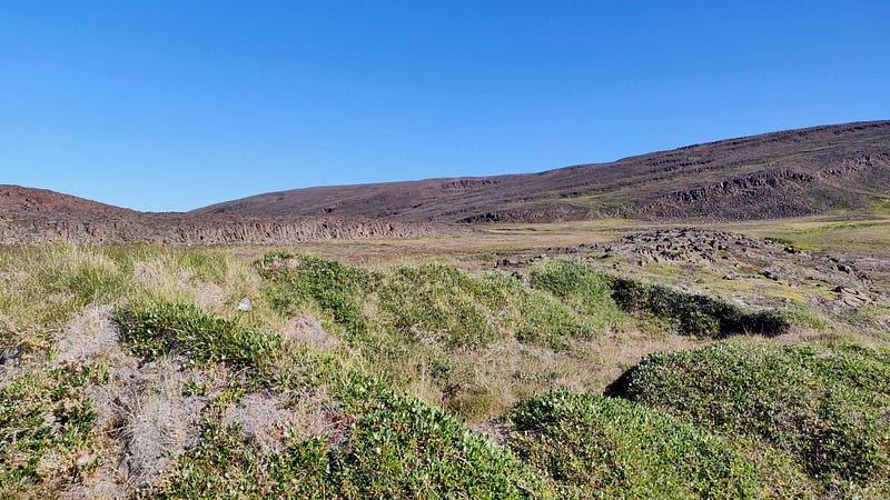
For the rest of the day we were completely disconnected from modern civilization. Few places are more remote. We were on a tiny spit of land at the very tip of very long peninsula in Northwest Greenland. I stopped philosophizing and pushed my thoughts aside. Our time at the Bear Trap was limited and we had a lot to do.
I assembled my base station and set out ground control points throughout the area. The ground control points would later allow me to ensure that the maps and other products were properly georeferenced. In other words, the ground control points helped me to ensure that the position of every point in my drone survey was as accurate as possible.
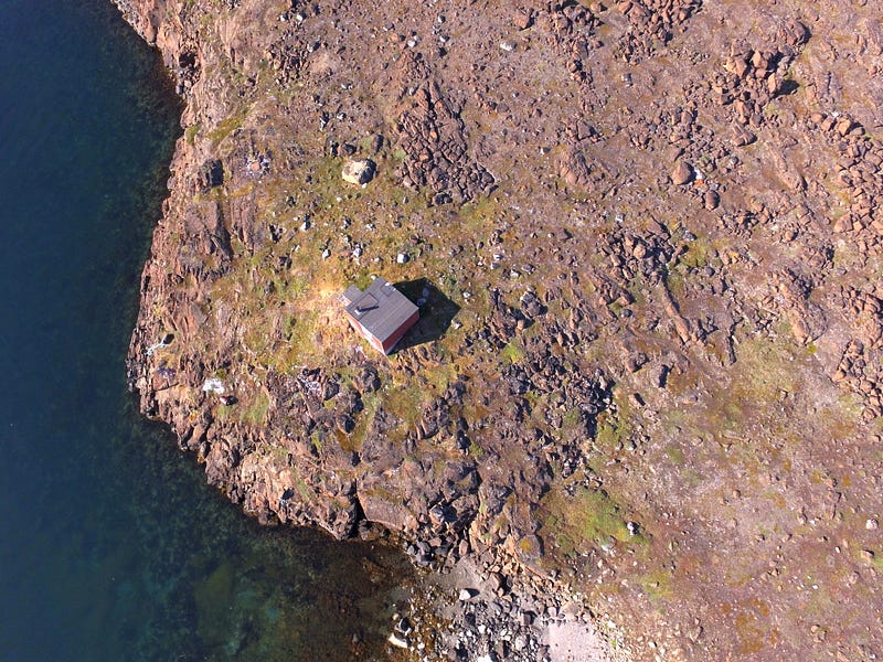
While setting out the ground control points, I noticed that we weren’t the only ones there. A small, center-console fishing boat was tied up near a modern hut. Reaching the far end of the natural harbor, I saw the remains of several pit houses. I did my best to stay focused, but I couldn’t help but wonder what living in this place must have been like, then and now.
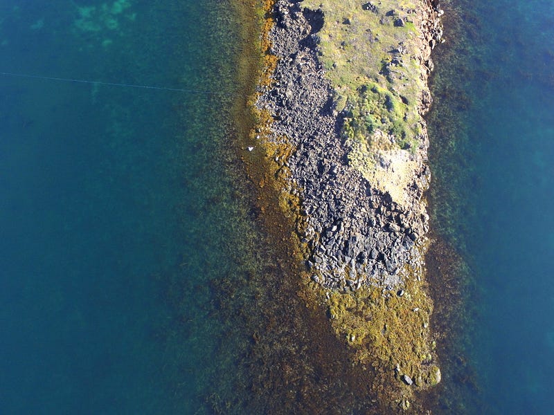
I flew two drone mapping missions: a large-scale survey of the area and a more detailed survey of the Bear Trap itself. These missions took a little over an hour to complete, resulting in over 600 drone images.
The large scale drone survey helped me to get a better overview of my surroundings. The modern hut and the remains of the pit houses were located at the southern end of the site. The drone images also revealed that the remains of the pit houses were rapidly eroding.
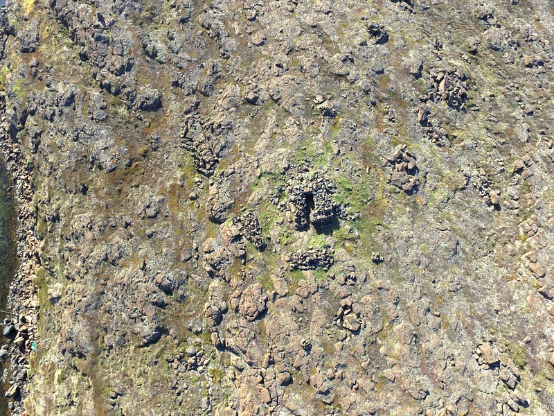
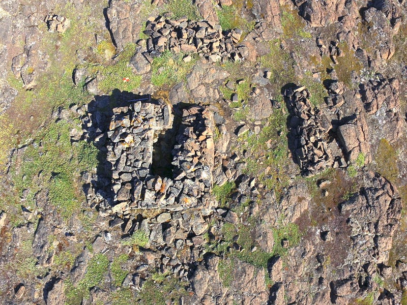
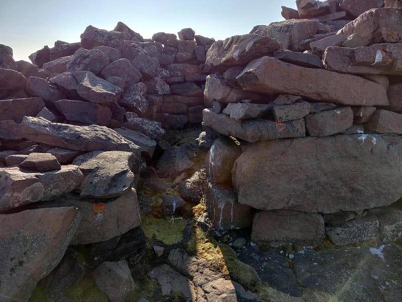
The Bear Trap was situated to the north, at the highest point on the promontory. Its square shape makes it easy to distinguish from the surrounding rocky landscape. When viewed up close it was also clearly evident that The Bear Trap was way too small to trap a bear. The entrance was simply too narrow for a bear to pass through.
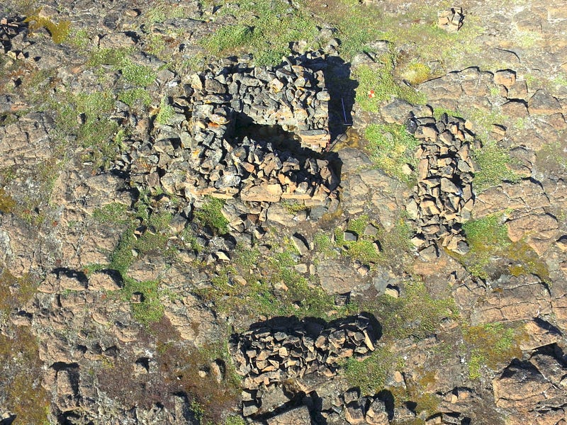
I thought that my mapping missions were complete so I started packing up my equipment. Then Matt showed me the graves. The area north of the Bear Trap contained at least five graves that were not mentioned in previous surveys of the site. They are well camouflaged, so it’s easy to see how the graves could have been missed. I laid out more ground control points and expanded the survey area to include the graves. Six hundred more images later, I was out out of batteries and done for the day.
Through Matt I learned that attempts to protect bodies from scavengers were futile so the bones were collected and buried under stone graves after the flesh had been consumed. What a way to go.
Matt’s grave findings were significant. Debate around the purpose of the Bear Trap included a theory that it had been used as a grave. The grave theory, however, lacked evidence. My digital replica of the Bear Trap clearly showed that bears could not fit through the entranceway. The interior of the Bear Trap, however, was just large enough for a body. The Norse held strong beliefs about burials. I can’t get into detail here, but let’s just say that screwing it up could leave you with a draugr, or a zombie of sorts, to deal with. Nobody, not even a Viking warrior, wants that.
The presence of other graves in the vicinity suggests that the area may have been viewed as hallowed ground. Thus, the Bear Trap was likely the temporary grave of a Norseman who perished on a summer hunting trip. The reviewers agreed with our findings, and our paper was recently published in Arctic Anthropology. I created an interactive explainer of our study using Cesium Stories where you can view the Bear Trap and some of the graves in 3D. And that’s how this oceanographer became an archaeologist for a day.
Contributing to this study pushed me out of my comfort zone as a scientist and as a father. Several of those graves held more than one body. I couldn’t help but think of the families that were buried here. I couldn’t help but think of the children who starved and the impossible decisions that parents had to make. I returned home with a profound appreciation for my family.
For more spiritual reading
I highly recommend Oksana Kukurudza's Sunflowers Rarely Break’s story of mystical walks. I completely agree that hiking can be more spiritual than a day in church.
Warren Thurlow’s pictures of Patagonia and his vivid descriptions of his experience were well worth the read.
A big thanks to Anne Bonfert for December’s monthly challenge!
For the interested reader
All the imagery data and end products are freely available.


