Everything about the lesser-known field of Photogrammetry
What is photogrammetry? What is it used for? Are there any softwares for it? How to be a photometrist?
Photogrammetry refers to a metric of a photogram. In simpler terms, it is the recording, measurement and interpretation of photographic images. Photographs of physical, geographical and environmental objects are interpreted more. Photogrammetry began with the use of photography in the 19th century. As usual, it was then done manually using optical machinery or analog tools but today there are softwares to do everything which was done manually years before. History even suggests that it was extensively used in WW1 and WW2 for military purposes and later on extended for civilian use.
Photogrammetry should be known and understood by everyone, especially the one who is in the field of Photography or Image Processing. As a Science or Engineering student, understanding photography, computer graphics, image processing is very much useful.
Technology of Photogrammetry
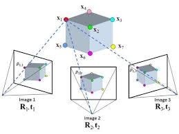
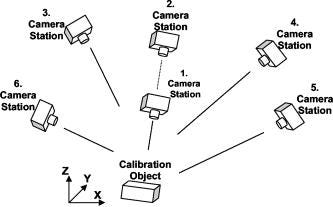
Just like how our eyes capture two views of the same object/point (perspective and depth), photogrammetry utilises at least two points taken from two different observations for analysis. A 3D image utilises a minimum of three views to capture an object onto the camera. Sometimes, even more, than one camera may be used and different images can be combined together to give a 3D view.
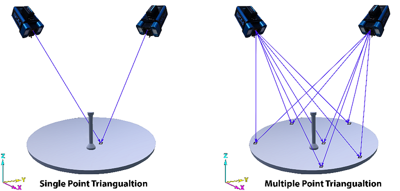
So if you have two different 2D images of the same object taken from two different perspectives you get a 3D image. But for real-life modelling and various applications, just three points won’t be enough. Thus, 360-degree view of the objects is ideal but since it might impossible, multiple images are assembled, uploaded to the computer, processed using software and give out useful information. This method is known as stereophotogrammetry.
Photogrammetry uses techniques and principles from various disciplines like Optics, Projection geometry, Mathematics etc.
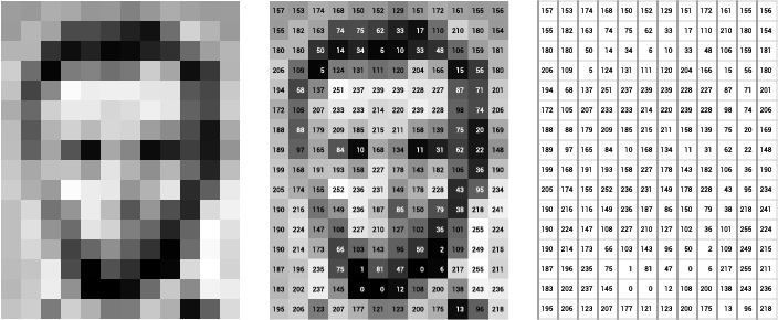
Images are organised in computers as pixels, which is basically rows and columns. Each pixel or a box has a value indicating the intensity of the pixels. Higher value, higher is the brightness. Mathematically an image is represented as a matrix with two coordinates (x,y). For a 3D image, each pixel is represented with three coordinates (x,y,z).
Vector images are images which have both magnitude and direction.
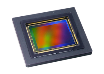
Image Sensors
The primary technology used in image sensing is Metal Oxide Semiconductor (MOS) of which MOS Field Effect Transistor (MOSFET) are also a part of. Digital Image Sensors, Charge-Coupled Devices (CCD) and Complementary MOS (NMOS) and N-type MOS Active Pixel Sensors (NMOS-APS).
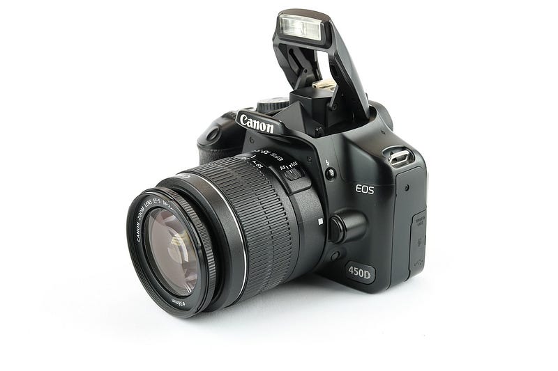
Digital cameras and Scanners are the most common forms of image capture devices. Nowadays, digital cameras are embedded inside laptops, webcams, mobile phones etc. Digital cameras use the shutter to control the amount of light entering the lens, it is then captured by an electronic pickup and in ordinary cameras, it was analog pickup/films. Digital cameras come with multiple features regarding editing, cropping, etc.
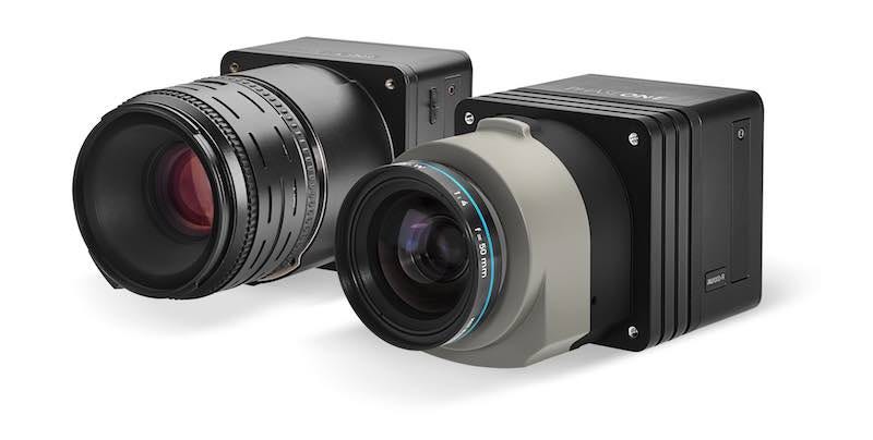
For 3D modelling and vast applications of Photogrammetry, Metric Cameras are used rather than ordinary cameras. These are cameras which have measurable variable focal length and internal dimensions that can be determined through the process of calibration. These cameras can withstand changes in atmospheric or any other motion disturbances. The quality and standard of the lens used is also high.
Storage and Viewing of Digital Images
Images can be stored anywhere just like how we store, usual text files, word files, etc. Popularly used storage devices include flash drives, magnetic storage, solid-state disk, SD cards etc. Now, most of the people instead of storing on their own devices, like to back-up on Cloud, like iCloud, Google Drive, Google Photos, One-Drive, Dropbox etc. The most sought way of storing images is JPG, PNG and GIF formats. A preview was made in olden times when uploading and downloading on the internet was complex, where the Preview is loaded for the user’s understanding. 3D objects are stored in STL, OBJ, FBX, COLLADA etc formats.

Digital Image Processing (DIP)
A field in engineering which deals with the processing of digital images using a digital computer through software and algorithms. DIP has made significant changes in the way how we process images compared to Analog Digital Processing.
Types
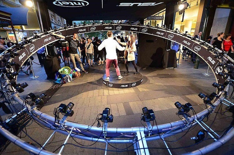
- Close range/terrestrial - Taking photos from a hand-held digital camera, or mobile phone from different sides and later generating 3D images. It also includes high-speed photography where even motion is analysed.
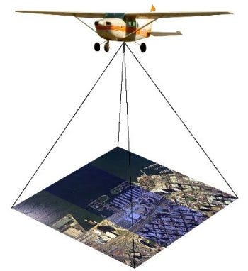
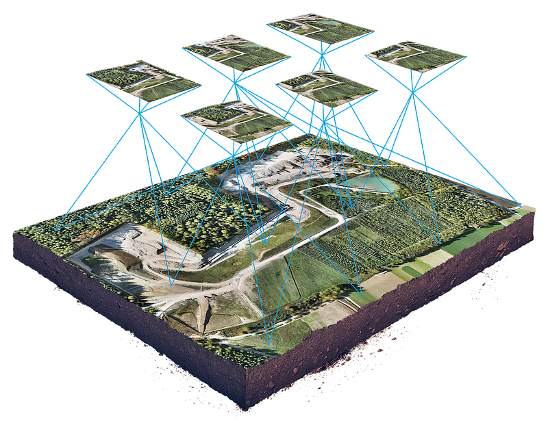
- Arial- Generally used for topographic uses. It captures images using aircraft/drone cameras and is mapped digitally. The drone is a newer concept thus, it is still not expanded or utilised properly. Due to its untapped potential, it is a preferred way of going to an inaccessible area and performs surveying.
Applications of Photogrammetry
The most important and significant part of technology is its utility and applications. Photogrammetry comes with a wide range of applications.
- Mapping Making maps/cartography is the biggest application of photogrammetry. This is one of the few technologies where Geography and Geology also come into play. Arial visuals of the ground are later combined together to give a proper map with various information like physical features, important locations, landmarks etc.
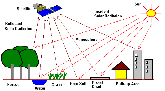
- Remote Sensing Photographs are taken by Remote Sensing Satellites and later these photographs can be manipulated to create 3D models for various applications like orthophoto mapping, orthophotos etc.
- Geographic Information System (GIS) It is a database application stores details of both manmade and physical features of given geographical area. Although it might sound similar to mapping, there is distinct between the two. GIS not only stores images but all types of data. GIS can be used to store data which comes from mapping.
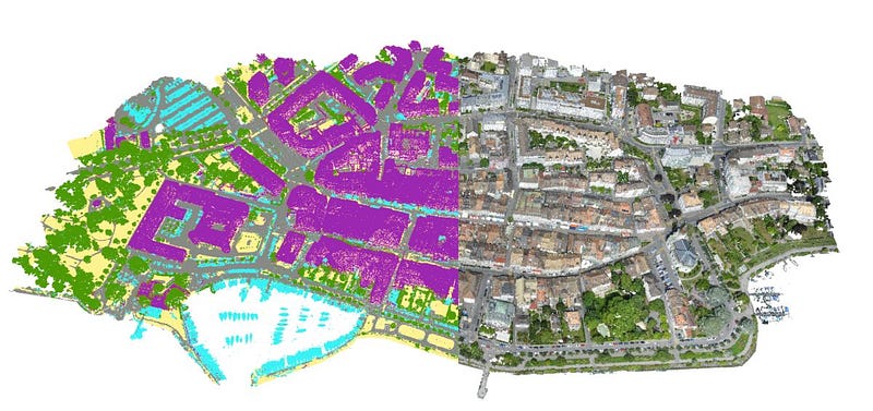
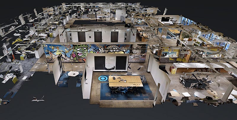
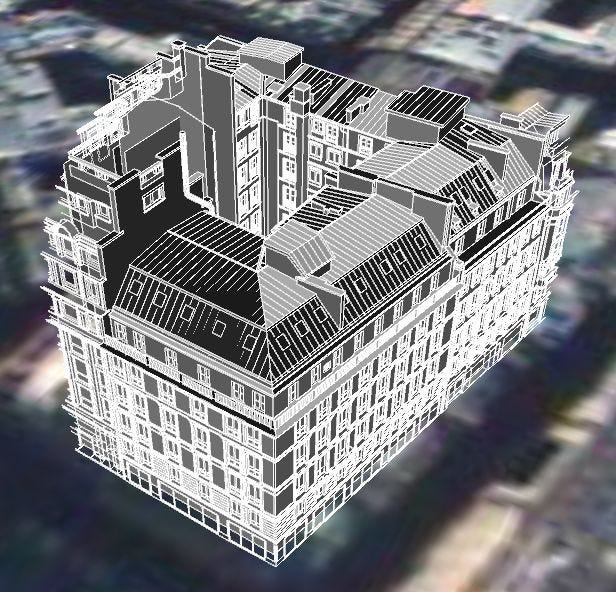
- 3D Modelling This will be the most interesting application for the majority of us, as we love 3D. There are multiple softwares which can be used to create 3D models out of two images. The best example of this Google Earth, which uses satellite, plane and on-ground 2D images to create a 3D model of the Earth.
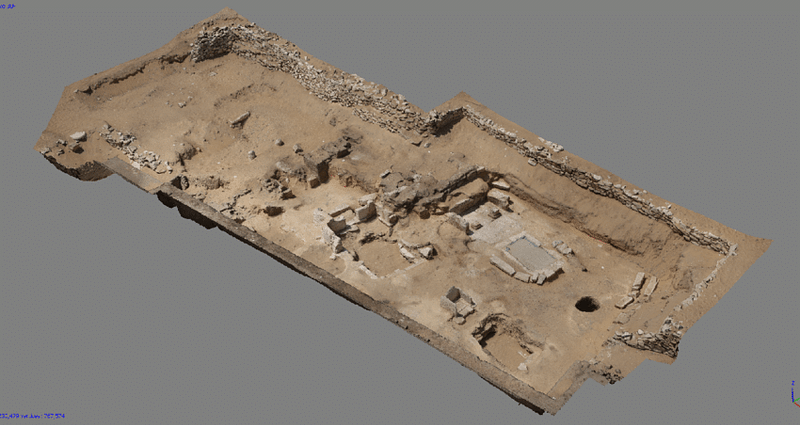
- Archaeology The old artefacts, ancient ruins etc can be analysed by converting into appropriate formats. Drawing pictures was famous in the olden days just like photography is a form of art today. It is still used to convey essential details and ideas. It is quite possible in future that Archeology will look into 3D Augmented Reality and Virtual Reality and implement them in future.
There are several other small, medium and big applications for this technology other than the ones which we have discussed till now.
Watch this small video to understand the working and applications of Photogrammetry through a real-life example.
What are the different softwares used for Photogrammetry?
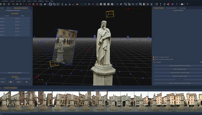
One of the crucial parts of the discussion will be, what all softwares are used for photogrammetry. Photomodeler and Autodesk are the most popular photogrammetric tools for generating and analysing 3D models.
Open Source Software like OpenDroneMap is also available if you don’t want a property software.
Career Opportunities
Photogrammetry is one of the demanding, skilled and high paid jobs across the Globe. Since it is a low competition field, chances are that you can excel in this field if you are ready to work hard and is interested in photography, photogrammetry, working with image processing, photogrammetry softwares etc. then this will be perfect on career choice for you. Just with basic knowledge of computer, an appropriate bachelors degree might help. A specialist in the field of photogrammetry is known as a Photogramatrist. Generally, a photogramatrist job is closely associated with that of Remote Sensing Satellites and Image process.
Another important career available in this field is a GIS specialist. He/She must work closely with LiDAR, LASER etc, making 3D topography of the Earth. Good understanding of various softwares, backend, DBMS will be required as well.
The operator of UAVs- You can be assigned to work closely with Unmanned Aerial Vehicle systems. UAVs are used where it is hard for humans to reach and get information. This includes photographs, audio, video etc. The most important application of UAVs is by militaries across the globe and is still a controversial subject. Even though most of the UAVs don’t require human presence to either operate or fly, Photogrammatrist needs to monitor details regarding the images, photographs and other operations. UAVs will have cameras and sensors inbuilt it in for its operations.
It is pretty much clear that digital photographs play an important part in our lives. Everything is now driven my digital, data and computers. Photogrammetry showcases us a field where multiple domains interact with each other and support each other with the help of latest technology. Nothing we learn in our lives goes waste.
Sources for the article content
Wikipedia, Science Direct, Auto Desk, Youtube, Cultural Heritage Imaging, Enclyclopedia2, Photomodeler, IEEE Xplore, Wisegeek, Surveying group, Google, Bing.
Follow us for more amazing and the latest science and technology articles. We are also there on social media. Follow us on Instagram|LinkedIn to stay updated!
***We also invite science and technology enthusiasts to write for us. If you think you have interesting stuff which the world should know about, send in your articles to us!***
HAVE A GREAT DAY!